
San Lorenzo de El Escorial, also known as El Escorial de Arriba, is a town and municipality in the Community of Madrid, Spain, located to the northwest of the region in the southeastern side of the Sierra de Guadarrama, at the foot of Mount Abantos and Las Machotas, 47 kilometres (29 mi) from Madrid. It is head of the eponymous judicial party. The settlement is popularly called El Escorial de Arriba, to differentiate it from the neighbouring village of El Escorial, also known as El Escorial de Abajo.

Naucalpan, officially Naucalpan de Juárez, is one of 125 municipalities located just northwest of Mexico City in the adjoining State of Mexico. The municipal seat is the city of Naucalpan de Juárez, which extends into the neighboring municipality of Huixquilucan.
Pozuelo de Alarcón is a municipality in the Community of Madrid, Spain. Bordering the Moncloa-Aravaca district of Madrid proper to its west, Pozuelo de Alarcón is surrounded by large Mediterranean pine-tree forests: the Casa de Campo, the Monte del Pardo, and the Monte del Pilar. As of 2019, it ranks as the wealthiest municipality in Spain. La Finca, an isolated luxury residential area known by its affluent residents, most notably football players, lies within the municipality bounds.
Miraflores is the name of several places in Spanish-speaking countries. It means "behold the flowers" or "flowers view" from mirar and flores ("flowers").
Móstoles is municipality of Spain located in the Community of Madrid. With over two hundred thousand inhabitants, it is the region's second most populated municipality after Madrid. Móstoles was for a long time a small town, but expanded rapidly in the second half of the 20th century.

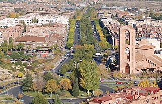
Las Rozas de Madrid is one of the largest townships and municipalities in the autonomous community of Madrid, Spain, with an area of 59 km². It is located 20 km northwest of the city of Madrid itself, on the A-6 freeway to A Coruña. Las Rozas is the beginning of this freeway, near the fork road M-505 to El Escorial, which marks the southern boundary of this 'comarca' or rural district.

Soto del Real, whose former name was Chozas de la Sierra, is a town and municipality in the northern area of the autonomous Community of Madrid which had 8,294 inhabitants in 2009.
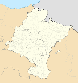
Lumbier is a village and municipality in the province and autonomous community of Navarre, in the north of Spain, 38 km from the capital of the community, Pamplona. It has a population of about 1400. It stands on the River Salazar in a region of natural interest. It also has interesting historical connections.

Colmenar Viejo is a town and municipality of about 48,614 inhabitants, located in the Community of Madrid, Spain, 30 kilometers north of Madrid on the M-607 motorway. It belongs to the comarca of Cuenca Alta del Manzanares.

The Sierra de Guadarrama is a mountain range forming the main eastern section of the Sistema Central, the system of mountain ranges along the centre of the Iberian Peninsula. It is located between the systems Sierra de Gredos in the province of Ávila, and Sierra de Ayllón in the province of Guadalajara.

Majadahonda is a municipality in Spain, situated 16 km (9.9 mi) northwest of Madrid, in the Community of Madrid.

Cuevas de San Marcos is a town and municipality in the province of Málaga, part of the autonomous community of Andalusia in southern Spain. The municipality is situated in the northern part of the Antequera region, on the border of the province of Córdoba from the river valley of Genil to the Sierra Malnombre and Camorro de Cuevas Altas. It is also located within the comarca of Nororma. It borders the provinces of Granada and Cordoba to the north, the comarcs of La Axarquía to the south and Antequera to the west. The town is situated at an altitude of 420 meters above sea level.

La Carolina is a city and municipality located in the province of Jaén, Spain. According to the 2014 census, the municipality has a population of 15,808 inhabitants.

Guijo de Santa Bárbara is a municipality located in the province of Cáceres, Extremadura, Spain. According to the 2005 census (INE), the municipality has a population of 429 inhabitants.

Buitrago del Lozoya is a municipality of the autonomous community of Madrid in central Spain. It belongs to the comarca of Sierra Norte. The town is one of the few in the community that have maintained its walls, which are of Moorish origin and have been restored in the 15th century. It lies on a peninsula surrounded by the Lozoya river.

La Cabrera is a municipality in central Spain, around 56km away from Madrid. La Cabrera belongs to the comarca called Sierra Norte de Madrid which is part of the wider autonomous Community of Madrid.

Navas del Rey is a municipality of the Community of Madrid, Spain. It is located 52 kilometers from the city of Madrid, which is accessed by the road M-501.

Santa María de la Alameda is a municipality of the Community of Madrid, Spain. It is linked to the city of Madrid and the town of El Escorial by regular train services. A popular weekend and holiday destination, Santa Maria is popular with anglers, hunters, walkers and outdoors enthusiasts.

Monachil is a municipality in the province of Granada, Spain. As of 2018, it has a population of 7,826 inhabitants. It lies around 8 km from the city of Granada. It borders the municipalities of Huétor Vega, Cenes de la Vega, Pinos Genil, Güéjar Sierra, Dílar, La Zubia and Cájar.

Somosierra is a municipality in the Community of Madrid, Spain, located at 83 km north of Madrid, in the mountain pass with the same name, at an elevation of 1433 metres above sea level, being the northernmost town of Community of Madrid. The Battle of Somosierra was fought here in 1808 during the Napoleonic Wars, and the Battle of Guadarrama was fought nearby in 1936 during the Spanish Civil War.


