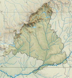
The Community of Madrid is one of the seventeen autonomous communities and 50 provinces of Spain. It is located in the centre of the Iberian Peninsula, and of the Central Plateau. Its capital and largest municipality is the City of Madrid, which is also the capital of the country. The Community of Madrid is bounded to the south and east by Castilla–La Mancha and to the north and west by Castile and León. It was formally created in 1983, in order to address the particular status of the City of Madrid as the national capital city and in urban hierarchy. Its boundaries are coextensive with those of the province of Madrid, which was until then conventionally included in the historical region of New Castile.

Alcalá de Henares is a Spanish city in the Community of Madrid. Straddling the Henares River, it is located 31 kilometres to the northeast of the center of Madrid. As of 2018, it has a population of 193,751, making it the region's third-most populated municipality.

The White Towns of Andalusia, or Pueblos Blancos, are a series of whitewashed towns and large villages in the northern part of the provinces of Cádiz and Málaga in southern Spain, mostly within the Sierra de Grazalema Natural Park.
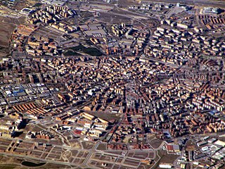
Móstoles is a municipality of Spain located in the Community of Madrid. With over 200,000 inhabitants, it is the region's second most populated municipality after Madrid. Móstoles was a small town for a long time, but expanded rapidly in the second half of the 20th century.

Getafe is a municipality and a city in Spain belonging to the Community of Madrid. As of 2018, it has a population of 180,747, the region's sixth most populated municipality.

Alcalá de Guadaíra is a town located approximately 17 km southeast of Seville, Spain; in recent years the expansion of Seville has meant that Alcalá has become a suburb of that city. Alcalá used to be known as Alcalá de los Panaderos because it provided most of Seville's bread. The town is located on the banks of the Guadaíra River, and watermills built during the Moorish period of Spain can still be found in the area.

Pedro Muñoz is a municipality in the autonomous community of Castile-La Mancha, Spain. It is located in the northeast corner of the province of Ciudad Real, on the bank of the Záncara river. It is in the La Mancha region, in the "Mancha Alta" sub-region. It was founded in 1284 by the Archdeacon of Alcaraz, Pero Muñoz, as one of a series of defensible points in the La Mancha plains. The village was abandoned in 1410, due to a severe drought, and re-established in 1525. Since the late 19th century, Pedro Muñoz had been an important economic center in the region.

Chiva is a municipality in the comarca of Hoya de Buñol in the Valencian Community, Spain. It has a population of 16,750 inhabitants. It is a Spanish-speaking town, in which Spanish has the legally recognised linguistic predominance compared to Valencian, co-official regional language of the Valencian Community. Part of the Hoya de Buñol region, it is located 31 kilometres inland following the A3 Highway from the capital of Valencia in direction towards Madrid.
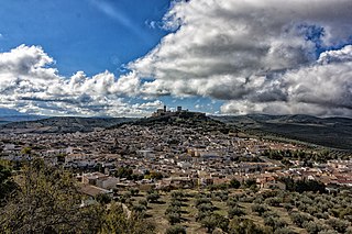
Alcalá la Real is a city in the province of Jaén, Spain. According to the 2006 census (INE), the city has a population of 22,129.

Azuqueca de Henares is a municipality located in the province of Guadalajara, Castile-La Mancha, Spain. According to the 2013 census (INE), the municipality had a population of 34,685 inhabitants. The mayor of Azuqueca is José Luis Blanco.
Meco is a municipality in the eastern part of the Autonomous Community of Madrid, (Spain). In 2006, Meco had a population of 11,094.

Valdemoro is a municipal district, located in the Southern zone of the autonomous community of Madrid, Spain. Located 27 kilometers from the capital, Valdemoro is officially part of the comarca of La Sagra, though it is generally also included in the Madrid metropolitan area.

Rivas-Vaciamadrid is the 15th most populated city in the Community of Madrid, Spain. It belongs to the Madrid metropolitan area and is located just 15 km from central Madrid, to the south-east. In the southern part of the municipality, the Manzanares river flows into the Jarama, which is part of the Lower Manzanares and Jarama Rivers Regional Park. Almost three quarters of the municipality form part of the park, making it an important ecological centre with numerous lakes and various species of wildlife and fauna.

Ambite is a municipality in the province of Madrid in central Spain. It belongs to the comarca of Alcalá. It has 648 inhabitants in an area of 26 square kilometres (10 sq mi), with a population density of 14.69 hab/km2. It lies 770 metres (2,530 ft) above sea level.

Algete is a town and municipality in central Spain. It lies in the comarca de Alcalá in the autonomous community of the Community of Madrid. It had a population of 20,767 in 2022. Algete is 30 kilometres (19 mi) northeast of the capital.

Perales de Tajuña is a town and municipality of Spain located in the Community of Madrid. It is about 40 km to the southeast of Madrid in the area known as the Comarca de Las Vegas. The municipality covers 48.92 km,2 and it has a population of 2,738 inhabitants and a population density of 55.97 inhabitants/km2. To the north it borders with Arganda del Rey and Campo Real, to the east with Tielmes, to the south with Villarejo de Salvanés, and to the west with Morata de Tajuña and Valdelaguna.
Colmenar de Oreja is a town and municipality of the Las Vegas comarca, in the Community of Madrid, Spain. It was subject to a seven-month siege in 1139.

La Vall d'Uixó is a town situated in eastern Spain, in the Valencian province of Castelló. La Vall is located 25 km to the south of the province's capital Castelló, 45 km to the north of the community's capital Valencia and 8 km to the Mediterranean Sea, and sits at 118 m above sea level.

Vicálvaro is a district in the southeast of Madrid, Spain. It is named after the former municipality absorbed into the municipality of Madrid in 1951.
Guissona is a town and municipality located in the north of the comarca (county) of Segarra, in the province of Lleida, Catalonia, Spain. With 6,862 inhabitants Guissona is the principal municipality in the northern half of Segarra and the second most populated in the county after Cervera. In addition to the populated place of Guissona, the municipality integrates the smaller place of Guarda-si-venes. The municipality is split into two parts, the bigger eastern part containing almost all the population.