Toledo is a province of central Spain, in the western part of the autonomous community of Castile–La Mancha. It is bordered by the provinces of Madrid, Cuenca, Ciudad Real, Badajoz, Cáceres, and Ávila. Its capital is the city of Toledo.

San Lorenzo de El Escorial, also known as El Escorial de Arriba, is a town and municipality in the Community of Madrid, Spain, located to the northwest of the region in the southeastern side of the Sierra de Guadarrama, at the foot of Mount Abantos and Las Machotas, 47 kilometres (29 mi) from Madrid. It is head of the eponymous judicial party. The settlement is popularly called El Escorial de Arriba, to differentiate it from the neighbouring village of El Escorial, also known as El Escorial de Abajo.
Pozuelo de Alarcón is a municipality in the Community of Madrid, Spain. Bordering the Moncloa-Aravaca district of Madrid proper to its west, Pozuelo de Alarcón is surrounded by large Mediterranean pine-tree forests: the Casa de Campo, the Monte del Pardo, and the Monte del Pilar. As of 2022, it ranks as the wealthiest municipality in Spain. La Finca, an isolated luxury residential area known by its affluent residents, most notably football players, lies within the municipality bounds.

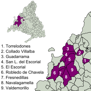
Valdemorillo is a Spanish town and municipality located in the Community of Madrid. The municipality, with a population of 13,453 inhabitants, includes, in addition to the town of Mojadillas, El Paraíso, Pino Alto Cazadero Real, Pino Alto Sector Sur, Jarabeltrán, Puentelasierra, La Esperanza, Montemorillo, Parque de las Infantas, La Pizarrera, Mirador del Romero, Los Barrancos and Cerro Alarcón shared with Navalagamella and Ampliación Cerro Alarcón. In the municipality is located part of the reservoir of Valmayor.
Móstoles is a municipality of Spain located in the Community of Madrid. With over 200,000 inhabitants, it is the region's second most populated municipality after Madrid. Móstoles was a small town for a long time, but expanded rapidly in the second half of the 20th century.

Las Rozas de Madrid is a municipality in the autonomous community of Madrid, Spain, with an area of 59 km² .

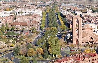
Villanueva de la Cañada is a municipality in the Community of Madrid, Spain. Located 30 km north-west from Madrid, the municipality covers an area of 34.92 km2. Geographically, it sits on a large plain, in which there are several promontories, on one of which is found the castle of Aulencia, its main landmark. The ESA's European Space Astronomy Centre lies close to the former, on the Guadarrama riverfront. Villafranca del Castillo, a well-off urban area detached from the main nucleus, is located within the municipal bounds. Villanueva de la Cañada hosts the main campus of the Alfonso X El Sabio University as well as the Aquópolis waterpark.

According to some historians Las Rozas de Madrid could have been a Roman mansion or staging-post called Miacum, from which the name Madrid may have derived. This is somewhat speculative, although there is evidence of occupation locally in about the 3rd century of the Common Era when the Roman Empire was active in Spain.
Fuenlabrada is a city and municipality of Spain located in the Community of Madrid. As of 2018, it has a population of 193,586, making it the region's fourth most populated municipality.
Collado Villalba is a municipality of the Community of Madrid, in central Spain. It is located 40.3 kilometres north-west of the city of Madrid, at an altitude of 917 meters above sea level. It has a population of 64,263 (2022), with a population density of about 2,400 per km2. Collado Villalba has a hot summer Mediterranean climate.

Centro is a district of Madrid, Spain. It is approximately 5.23 km2 in size. It has a population of 149,718 people and a population density of 28,587/km2. It roughly corresponds to the bulk of the housing formerly enclosed by the so-called Walls of Philip IV. The district is made up of the neighbourhoods of Cortes, Embajadores, Justicia, Universidad, Palacio and Sol.
Collado Mediano is a town and municipality in the north-west of the Community of Madrid, Spain. It had a population of 6,610 in 2011 and is located 48 km from Madrid. The municipality covers an area of 22.57 km2. Located near the Sierra de Guadarrama, it lies at 1,032 metres above sea level.

Galapagar is a town and municipality northwest of Madrid, Spain, situated in the autonomous community of the Community of Madrid. Of all the towns in the area, it was experiencing the most growth, mostly because of immigration and the conversion of old livestock fields into terrain for construction.

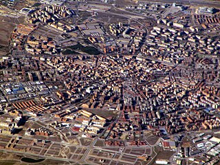
Parla is a municipality in the Community of Madrid, Spain. It is located in the southern part of the region, approximately 20 km from the capital, Madrid.

Torrelodones is a municipality in the northwest of the Autonomous Community of Madrid, Spain. It is situated 29 kilometers northwest from the city of Madrid. Because of its location between the Sierra de Guadarrama and the metropolitan area of the capital, it is linked to two districts in Madrid: the agricultural area of Guadarrama and the metropolitan area of Madrid.

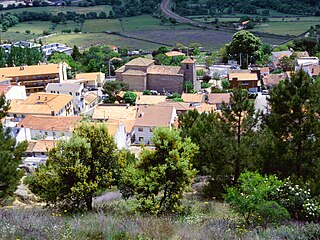
Navas del Rey is a municipality of the Community of Madrid, Spain. It is located 52 kilometers from the city of Madrid, which is accessed by the road M-501.

Villanueva del Pardillo is a municipality and Spanish town of the Community of Madrid, situated 26 kilometers from the capital of Spain and nestled in the natural environment of the Cuenca del Guadarrama. It borders the municipalities of Majadahonda, Las Rozas de Madrid, Villanueva de la Cañada, Galapagar, Colmenarejo and Valdemorillo.

Los Negrales is a residential zone in the municipal area of Collado Villalba, Alpedrete, San Lorenzo de El Escorial, Guadarrama and Galapagar, consisting mostly of detached houses. Although it was divided in three administrative zones, Los Negrales is a contiguous residential area. This residential zone was built gradually. The oldest houses date to the first half of the 20th century, and building has continued until contemporary times. A significant part of the houses are second residences of their owners, therefore, in summer and in holidays the population doubles.

The Sierra de Hoyo or Sierra de Hoyo de Manzanares is a mountain chain located in the northwest of the Community of Madrid (Spain), near the Sierra de Guadarrama. Geologically it belongs to this mountainous formation, but there is a flat separation of about ten kilometers between the two. Its main municipality of reference is Hoyo de Manzanares, located on its southern slope, from which it takes its name.
The Imperial Route of the Community of Madrid is the tourist itinerary promoted by the Ministry of Culture and Tourism of this Spanish region, which runs through several municipalities in the Sierra de Guadarrama. It partially follows the historical road that led to the Monastery of El Escorial, used in the 16th century by King Philip II in his travels from the city of Madrid to the Royal Site.