The Arctic Archipelago, also known as the Canadian Arctic Archipelago, groups together all islands lying to the north of the Canadian continental mainland excluding Greenland.

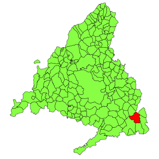
Batres is a small town and municipality in the autonomous community of Madrid in central Spain. The town as is known today was founded in the 12th century after it was recaptured by the Spaniards from the Almoravids, or north African settlers.

Brión is a municipality in the province of A Coruña, in the autonomous community of Galicia in northwestern Spain. It belongs to the comarca of Santiago de Compostela and is 13 km to the east of Santiago de Compostela. It has an area of 74.9 square kilometres (28.9 sq mi), and a population of 7,519 inhabitants (2014).

Hernán-Pérez is a municipality located in the province of Cáceres, Extremadura, Spain. According to the 2011 census (INE), the municipality has a population of 510 inhabitants.

Santibáñez el Bajo is a municipality located in the province of Cáceres, Extremadura, Spain. According to the 2006 census (INE), the municipality has a population of 863 inhabitants.
Torre de Don Miguel is a municipality located in the province of Cáceres, Extremadura, Spain. According to the 2005 census (INE), the municipality has a population of 612 inhabitants.

Ugena is a municipality located in the province of Toledo, Castile-La Mancha, Spain. According to the 2006 census (INE), the municipality has a population of 3942 inhabitants.

Villaconancio is a municipality located in the province of Palencia, Castile and León, Spain. According to the 2004 census (INE), the municipality has a population of 85 inhabitants.

Berlangas de Roa is a municipality and town located in the province of Burgos, Castile and León, Spain. According to the 2004 census (INE), the municipality has a population of 226 inhabitants.

Fuentecén is a municipality located in the province of Burgos, Castile and León, Spain. According to the 2004 census (INE), the municipality has a population of 285 inhabitants.

Hoyales de Roa is a municipality located in the province of Burgos, Castile and León, Spain. According to the 2004 census (INE), the municipality has a population of 269 inhabitants.

Tordómar is a municipality and town located in the province of Burgos, Castile and León, Spain. According to the 2004 census (INE), the municipality has a population of 351 inhabitants.

Şıxlar is a village in the Khizi Rayon of Azerbaijan.
This is a list of the extreme points and extreme elevations in Scotland.

Yecuatla is a municipality located in the north zone in the State of Veracruz, about 40 km from state capital Xalapa. It has a surface of 135.72 km2. It is located at 19°52′N96°47′W. The name comes from the language Náhuatl, Yec-uauh-tlan; that means “Place of three snakes ".
Valdaracete is a municipality of the Community of Madrid, Spain.

Valdemanco is a municipality of the Community of Madrid, Spain.

Frankenfield Glacier is a small glacier in the northeast part of Noville Peninsula, Thurston Island, in Antarctica. It flows east-northeast to the Bellingshausen Sea between Mount Feury and Mulroy Island. The glacier was first roughly delineated from air photos taken by U.S. Navy Operation Highjump in December 1946, and was named by the Advisory Committee on Antarctic Names for Lieutenant Chester Frankenfield, a meteorologist on the U.S. Navy Bellingshausen Sea Expedition, who established an automated weather station on Thurston Island in February 1960.