Torrelodones

Last updated
Torrelodones
Torre vigia en Torrelodones.jpg
Watchtower of Torrelodones, gives the name to the municipality
Bandera de Torrelodones.svg
Coat of Arms of Torrelodones.svg
Nickname: 
Torre
Torrelodones en la Comunidad de Madrid.png
Location in the Community of Madrid, Spain
Spain Madrid location map.svg
Red pog.svg
Torrelodones
Spain location map with provinces.svg
Red pog.svg
Torrelodones
Coordinates(Town Hall): 40°34′32″N3°55′45″W / 40.57556°N 3.92917°W / 40.57556; -3.92917
Country Spain
Autonomous community Community of Madrid
Province Madrid
Comarcas Madrid metropolitan area
Comarca agrícola de Guadarrama
Administrative Divisions 3
Foundedc.VII century
Population nucleiPueblo, Colonia, Los Peñascales
Government
   Alcaldesa Almudena Negro (PP)
Area
  Total21.95 km2 (8.47 sq mi)
Elevation
845 m (2,772 ft)
Highest elevation
1,011 m (3,317 ft)
Lowest elevation
675 m (2,215 ft)
Population
 (2021) [1]
  Total24,122
  Density1,053.67/km2 (2,729.0/sq mi)
Time zone UTC+01:00 (CET)
  Summer (DST) UTC+02:00 (CEST)
Postal code
28250
Area codes +34 (Spain) + 91 (Madrid)
Website torrelodones.es

Torrelodones is a municipality in the northwest of the Autonomous Community of Madrid, Spain. It is situated 29 kilometers northwest from the city of Madrid. Because of its location between the Sierra de Guadarrama and the metropolitan area of the capital, it is linked to two districts in Madrid: the agricultural area of Guadarrama and the metropolitan area of Madrid.

Contents

It lies at an average altitude of 845 meters. According to the 2022 census, 24,775 people live in the municipality, distributed among seven towns. [2]

The people of Torrelodones earn among the highest per capita incomes of the Community of Madrid. Services, hotels, and construction are the main economic activities. In 2012 it had about 22,680 inhabitants. With over three colleges and four developments, Torrelodones is usually divided into two parts: the "Torrelodones town", where there is the Town Hall, and the "Torrelodones colony", where there are schools, homes and small businesses.

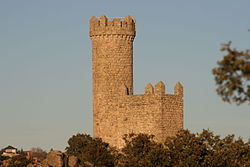
The town has an interesting artistic and natural heritage and is part of two tourist routes in the Community of Madrid. One of them is the Imperial Route, which partially follows the historic route used in the 16th century by King Philip II in his travels from the city of Madrid to the Royal Site of El Escorial. [3] The other is the Route through the Castles, Fortresses and Watchtowers, to which it is linked by the Watchtower of Torrelodones.

Torrelodones is bordered to the north by Hoyo de Manzanares, to the south by Las Rozas de Madrid, to the west by Galapagar, and to the east by Madrid (through El Monte de El Pardo).

Historically the municipality was named "Torrelodones" (Lodones' Tower). That name led to the current name of the town Torrelodones. The name comes from, for one side, the Muslim watchtower that Muslims used during Al-andalus age to guard the city from the attacks of Christian people during the Iberian peninsula's reconquest. For the other side, "Lodon" (hack berry) is a type of tree that was really abundant in that zone whose scientific name is Celtis australis .

Symbols

The town's badge, or coat of arms, was approved in 1979 by the "Real Decreto 3086/1979", of December 14. Its official description in Spanish is:

EscudoPartido, primero, de plata. la torre de azur; se• gundü, de azur, la banda de oro, engolada en dragantes del mismo metal y en punta, de plata, el almez o lodón frutado de sable. Al timbre, corona real cerrada.

This literally translates as: "Badge divided, first, of silver, the tower on azure, second, in azure, the gold band, with dragon heads of the same metal, and in peak, of silver, the hack berry of saber. On the top, a royal crown closed."

The town's flag was approved by Madrid's community on 12 February 1992, and was designed by Julian Nieto Martin. The flag's description is:

"Rectangular flag, of 2:3 ratio divided diagonally in 2 equal portions from the right top corner to the bottom left corner, blue on the top and yellow on the bottom; in the middle the officially approved coat of arms."

Urban geography

Boundaries

Torrelodones is bounded by the following:

Towns

Torrelodones' population is spread in seven officially recognized different towns: Torrelodones (center), Los Robles, Los Peñascales, Los Bomberos, La Estacion, La Berzosilla, El Gasco. There are other neighborhoods isolated apart from those seven towns but they are not officially recognized.

TownsCoordinatesPopulation (2009)
Torrelodones (center)40°34′35″N 3°55′46″O8272
Los Robles40°35′7″N 3°55′14″O1292
Los Peñascales40°34′19″N 3°53′52″O4218
Los Bomberos40°34′12″N 3°55′35″O1262
La Estación40°34′36″N 3°56′58″O5336
La Berzosilla40°35′12″N 3°56′51″O528
El Gasco40°34′3″N 3°56′44″O323Total21231

Urban habitat

Torrelodones is divided in two parts: Torrelodones-pueblo (Torrelodones town), and Torrelodones-colonia (Torrelodones colony).

Torrelodones-pueblo has the historical part of the municipality. It was developed in the early Middle Ages around a street that still exists now, called Calle Real (Royal Street). Through the twentieth century the town started to expand with the construction of new buildings, new business and small stores.

In the late nineteenth century the Torrelodones-colonia part arose around the railway station; it is still developing. It consisted of small townhouses, apartments and villas.

Both the Torrelodones-pueblo and the Torrelodones-colonia are the main social, administrative and economic centers of the municipality. They hold the 64% of the population and the vast majority of businesses, industries and services available in the village.

Panoramic view of Torrelodones town Torrelodones. Vista panoramica desde Polideportivo.jpg
Panoramic view of Torrelodones town

Climate

Torrelodones's weather is continental Mediterranean. It has cold winters with temperatures less than 5 °C, frequents frosts at nights and occasionally snows. Summers are warm, around 25 °C, and with maximum temperatures that can reach over 35 °C. The annual rainfall is more than 400mm.

Torrelodones' average climatic parameters in the period 1961-2003
MonthJanFebMarAprMayJunJulAugSepOctNovDicAnnual
Total rainfall (mm)57.846.734.851.151.830.110.810.733.656.080.160.0523.6

Flora

The municipality has much Mediterranean flora that is typical of Spain.

Trees there mainly are Holm oaks, with the occasional presence of junipers, oaks and pine trees, and spontaneous pine reforestation.

Wildlife

Torrelodones joins two protected ecological spaces: Sierra de Hoyo and Monte del Pardo.

Animals that live here include birds, mammals, reptiles, amphibians and invertebrates. All of them are included in the Catálogo Nacional de Especies Amenazadas and the Catálogo Regional de Especies Amenazadas de Fauna y Flora de la Comunidad de Madrid.

Birds

Águila imperial ibérica. (Aquila adalberti) (Spanish imperial eagle) is the most important bird.[ peacock prose ]

Spanish Imperial Eagle. Aguila imperial iberica.jpg
Spanish Imperial Eagle.
Aquila adalberti, La Canada.jpg

Other birds include Picogordo ( Coccothraustes coccothraustes ), curruca mosquitera ( Sylvia borin ), curruca zarcera ( Sylvia communis ), curruca mirlona ( Sylvia hortensis ), papamoscas gris ( Muscicapa striata ), oropéndola ( Oriolus oriolus ), collalba rubia ( Oenanthe hispanica ), chochín (Troglodytes troglodytes), pito real ( Picus viridis ), mochuelo ( Athene noctua ), autillo ( Otus scops ), abubilla ( Upupa epops ), carbonero común ( Parus major ), alcaudón real ( Lanius meridionalis ), alcaudón común ( Lanius senator ), abejaruco ( Merops apiaster ), estornino ( Sturnus unicolor ), rabilargo ( Cyanopica cooki ), El petirrojo ( Erithacus rubecula ), el ruiseñor ( Luscinia megarhynchos ), el mirlo ( Turdus merula ), el verdecillo ( Serinus serinus ), el verderón ( Carduelis chloris ), el pardillo ( Carduelis cannabina ), and el zorzal ( Turdus spp.).

There are also some species for hunting, such as la perdiz ( Alectoris rufa ), la codorniz ( Coturnix coturnix ), la tórtola ( Streptopelia turtur ) and la paloma torcaz ( Columba palumbus ).

Among the raptor birds are aguilucho ratonero ( Buteo buteo ) and al elanio azul ( Elanus caeruleus ).


Mammals

The municipality shelters, especially in protected zones, ardilla roja ( Sciurus vulgaris ), erizo europeo ( Erinaceus europaeus ), conejo ( Oryctolagus cuniculus ), liebre ibérica ( Lepus granatensis ), comadreja ( Mustela nivalis ), gineta ( Genetta genetta ), zorro ( Vulpes vulpes ), jabalí ( Sus scrofa ), el ratón de campo ( Apodemus sylvaticus ), el ratón casero ( Mus domesticus ), el lirón careto ( Eliomys quercinus ), la musaraña gris ( Crocidura russula ), el topo ibérico ( Talpa occidentalis ), and topillo de Cabrera ( Microtus cabrerae ).

Jabali Un jabali.JPG
Jabalí


Reptiles and amphibians

Torrelodones hosts reptiles such as la lagartija colirroja ( Psammodromus algirus ), la lagartija cenicienta ( Psammodromus hispanicus ), la lagartija ibérica ( Podarcis hispanicus ), el lagarto ocelado ( Lacerta lepida ), la salamanquesa común ( Tarentola mauritanica ), la culebrilla ciega ( Amphisbaenia ), la culebra de collar ( Natrix natrix ), la culebra viperina ( Natrix maura ) and la culebra de escalera ( Elaphe scalaris ).

Among the amphibians are el sapo corredor ( Bufo calamita ), el sapo de espuelas (Pelobates cultipes), el sapo partero ibérico ( Alytes cisternasii ), el sapillo pintojo ibérico ( Discoglossus galganoi ), and el gallipato ( Pleurodeles waltl ).


Invertebrates

There are countless species of invertebrates.

On record are two species of endangered Lepidoptera: el arlequín ( Zerynthia rumina ) and la doncella de ondas ( Euphydryas aurinia ).


Zorro (red fox) Zorro rojo.jpg
Zorro (red fox)
La culebra de collar AD2009Aug07 Natrix natrix 01.jpg
La culebra de collar
El sapo corredor Bufo calamita224.jpg
El sapo corredor
El Arlequin Arturo Nikolai - Parece un Arlequin (by-sa).jpg
El Arlequin

Related Research Articles

<span class="mw-page-title-main">Manzanares (river)</span> River in Spain

The Manzanares is a river in the centre of the Iberian Peninsula, which flows from the Sierra de Guadarrama, passes through Madrid, and eventually empties into the Jarama river, which in turn is a right-bank tributary to the Tagus.

<span class="mw-page-title-main">Valdemorillo</span> Municipality in Community of Madrid, Spain

Valdemorillo is a Spanish town and municipality located in the Community of Madrid. The municipality, with a population of 13,453 inhabitants, includes, in addition to the town of Mojadillas, El Paraíso, Pino Alto Cazadero Real, Pino Alto Sector Sur, Jarabeltrán, Puentelasierra, La Esperanza, Montemorillo, Parque de las Infantas, La Pizarrera, Mirador del Romero, Los Barrancos and Cerro Alarcón shared with Navalagamella and Ampliación Cerro Alarcón. In the municipality is located part of the reservoir of Valmayor.

<span class="mw-page-title-main">Móstoles</span> Municipality in Community of Madrid, Spain

Móstoles is a municipality of Spain located in the Community of Madrid. With over 200,000 inhabitants, it is the region's second most populated municipality after Madrid. Móstoles was a small town for a long time, but expanded rapidly in the second half of the 20th century.

<span class="mw-page-title-main">Las Rozas de Madrid</span> Place in Community of Madrid, Spain

Las Rozas de Madrid is a municipality in the autonomous community of Madrid, Spain, with an area of 59 km².

<span class="mw-page-title-main">History of Las Rozas</span>

According to some historians Las Rozas de Madrid could have been a Roman mansion or staging-post called Miacum, from which the name Madrid may have derived. This is somewhat speculative, although there is evidence of occupation locally in about the 3rd century of the Common Era when the Roman Empire was active in Spain.

<span class="mw-page-title-main">Colmenar Viejo</span> Municipality in Community of Madrid, Spain

Colmenar Viejo is a town and municipality of about 48,614 inhabitants, located in the Community of Madrid, Spain, 30 kilometers north of Madrid on the M-607 motorway. It belongs to the comarca of Cuenca Alta del Manzanares.

<span class="mw-page-title-main">Sierra de Guadarrama</span> Mountain range in Spain

The Sierra de Guadarrama is a mountain range forming the main eastern section of the Sistema Central, the system of mountain ranges along the centre of the Iberian Peninsula. It is located between the systems Sierra de Gredos in the province of Ávila, and Sierra de Ayllón in the province of Guadalajara.

<span class="mw-page-title-main">Collado Villalba</span> Place in Community of Madrid, Spain

Collado Villalba is a municipality of the Community of Madrid, in central Spain. It is located 40.3 kilometres north-west of the city of Madrid, at an altitude of 917 meters above sea level. It has a population of 64,263 (2022), with a population density of about 2,400 per km². Collado Villalba has a hot summer Mediterranean climate.

<span class="mw-page-title-main">Colmenarejo</span> Place in Madrid, Spain

Colmenarejo is a Spanish town and municipality in the Community of Madrid, located in the northwest of the region, in the foothills of the Sierra de Guadarrama, 899 meters high and 37 kilometers away from the capital. It is bordered to the north by El Escorial, to the east by Galapagar, to the south by Villanueva del Pardillo and to the west by Valdemorillo. Its only road access is the M 510, from Galapagar or from Valdemorillo. It has in its municipality with the east bank of the reservoir of Valmayor, second in capacity of the Region of Madrid, with the third Campus of the University Carlos III of Madrid and with an attractive natural environment, where you can go for walks with a bicycle, within the Regional Park of the middle course of the Guadarrama River and its surroundings, in which stand out the holm oaks and pastures of cattle use dotted with junipers, ash trees and gall oaks.

<span class="mw-page-title-main">Manzanares el Real</span> Municipality in Community of Madrid, Spain

Manzanares el Real is a 8,936 inhabitant town in the northern area of the autonomous Community of Madrid. It is located at the foot of The Pedriza, a part of the Sierra de Guadarrama, and next to the embalse de Santillana.

<span class="mw-page-title-main">Galapagar</span> Municipality in Community of Madrid, Spain

Galapagar is a town and municipality northwest of Madrid, Spain, situated in the autonomous community of the Community of Madrid. Of all the towns in the area, it was experiencing the most growth, mostly because of immigration and the conversion of old livestock fields into terrain for construction.

<span class="mw-page-title-main">Herrerian style</span> Architectural style in Renaissance Spain

The Herrerian style of architecture was developed in Spain during the last third of the 16th century under the reign of Philip II (1556–1598), and continued in force in the 17th century, but transformed by the Baroque style of the time. It corresponds to the third and final stage of Spanish Renaissance architecture, whose dominant trend had been towards austerity and minimal decoration. The ornate Plateresque style had given way to classical Purism in the second third of the 16th century. Purism in turn had given way to the geometric simplicity of the Herrerian style.

<span class="mw-page-title-main">El Pardo</span> Ward of Madrid in Spain

El Pardo is a ward (barrio) of Madrid belonging to the district of Fuencarral-El Pardo. As of 2008 its population was of 3,656.

<span class="mw-page-title-main">Sistema Ibérico</span> Major system of mountain ranges in Spain

The Iberian System is one of the major systems of mountain ranges in Spain. It consists of a vast and complex area of mostly relatively high and rugged mountain chains and massifs located in the central region of the Iberian Peninsula, but reaching almost the Mediterranean coast in the Valencian Community in the east.

<span class="mw-page-title-main">Becerril de la Sierra</span> Municipality in Community of Madrid, Spain

Becerril de la Sierra is a municipality of the autonomous community of Madrid in central Spain.

Hoyo de Manzanares is a municipality of the Community of Madrid, Spain, and is located on the northwestern side of the Community of Madrid and to the south of the Sierra de Guadarrama.

<span class="mw-page-title-main">La Maliciosa</span> Mountain in Spain

La Maliciosa is one of the most important and highest mountains of the Sierra de Guadarrama, a mountainous formation belonging to the Sistema Central. It has an altitude of 2227m above sea level and is located in the northwest of the Community of Madrid, in Spain, rising between La Pedriza, which lies to the east, and La Barranca valley, which is on its western slope.

<span class="mw-page-title-main">Cuenca Alta del Manzanares Regional Park</span>

The Cuenca Alta del Manzanares Regional Park, created in 1985, is the natural space protected area with the largest extension in the Community of Madrid (Spain) and one of the most ecologically and scenically valuable. It is located in the northwest of the region and extends around the upper course of the Manzanares River, along 42 583 ha. Its main municipalities of reference are Manzanares el Real and Hoyo de Manzanares. Unesco declared it a Biosphere Reserve in 1992.

<span class="mw-page-title-main">Sierra de Hoyo de Manzanares</span> Mountain chain in Spain

The Sierra de Hoyo or Sierra de Hoyo de Manzanares is a mountain chain located in the northwest of the Community of Madrid (Spain), near the Sierra de Guadarrama. Geologically it belongs to this mountainous formation, but there is a flat separation of about ten kilometers between the two. Its main municipality of reference is Hoyo de Manzanares, located on its southern slope, from which it takes its name.

<span class="mw-page-title-main">Imperial Route of the Community of Madrid</span> Spanish regional tourist itinerary

The Imperial Route of the Community of Madrid is the tourist itinerary promoted by the Ministry of Culture and Tourism of this Spanish region, which runs through several municipalities in the Sierra de Guadarrama. It partially follows the historical road that led to the Monastery of El Escorial, used in the 16th century by King Philip II in his travels from the city of Madrid to the Royal Site.

References

  1. Municipal Register of Spain 2018. National Statistics Institute.
  2. "Madrid: Población por municipios y sexo. (2881)". INE (in Spanish). Retrieved 2023-10-11.
  3. "Descripción de la Ruta Imperial de la Comunidad de Madrid, de carácter turístico" (PDF) (in Spanish). tauricio.com. Archived from the original (PDF) on 30 May 2009. Retrieved 10 May 2009.