Transport in Spain is characterised by a network of roads, railways, trams, air routes, and ports. Its geographic location makes it an important link between Europe, Africa, and the Americas. Major forms of transit generally radiate from the capital, Madrid, located in the centre of the country, to link with the capitals of the autonomous communities.

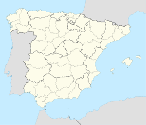
The Community of Madrid is one of the seventeen autonomous communities of Spain. It is located in the centre of the Iberian Peninsula, and of the Central Plateau. Its capital and largest municipality is the City of Madrid, which is also the capital of the country. The Community of Madrid is bounded to the south and east by Castilla–La Mancha and to the north and west by Castile and León. It was formally created in 1983, in order to address the particular status of the City of Madrid as the national capital city and in urban hierarchy. Its limits are those of the province of Madrid, which was until then conventionally included in the historical region of New Castile.

The Madrid Metro is a rapid transit system serving the city of Madrid, capital of Spain. The system is the 14th longest rapid transit system in the world, with a total length of 293 km (182 mi). Its growth between 1995 and 2007 put it among the fastest-growing networks in the world at the time. However, the European debt crisis greatly slowed expansion plans, with many projects being postponed and canceled. Unlike normal Spanish road and rail traffic, which drive on the right, Madrid Metro trains use left-hand running on all lines because traffic in Madrid drove on the left until 1924, five years after the system started operating.

Rail transport in Spain operates on four rail gauges and services are operated by a variety of private and public operators. Total railway length in 2020 was 15,489 km. The Spanish high-speed rail network is the longest HSR network in Europe with 3,966 km and the second longest in the world, after China's.
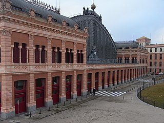
Madrid Atocha, also named Madrid Puerta de Atocha–Almudena Grandes, is the first major railway station in Madrid. It is the largest station serving commuter trains (Cercanías), regional trains from the south and southeast, intercity trains from Navarre, Cádiz and Huelva (Andalusia) and La Rioja, and the AVE high speed trains from Girona, Tarragona and Barcelona (Catalonia), Huesca and Zaragoza (Aragon), Sevilla, Córdoba, Málaga and Granada (Andalusia), Valencia, Castellón and Alicante. These train services are run by Spain's national rail company, Renfe. As of 2019, this station has daily services to Marseille, France.

Leganés is a city in the Community of Madrid, Spain. Considered part of the Madrid metropolitan area, it is located about 11 km southwest of the centre of Madrid. As of 2018, it has a population of 188,425, making it the region's fifth most populated municipality. It covers an area of 43.09 km2 and it is located at 667 m over sea level.

Getafe is a municipality and a city in Spain belonging to the Community of Madrid. As of 2018, it has a population of 180,747, the region's sixth most populated municipality.

Alcobendas is a municipality of Spain located in the Community of Madrid.

San Sebastián de los Reyes is a municipality in the Community of Madrid, Spain. Founded in 1492, it is located 20 kilometres (12 mi) north of Madrid.

Cercanías Madrid is the commuter rail service that serves Madrid, the capital of Spain, and its metropolitan area. It is operated by Cercanías Renfe, the commuter rail division of Renfe, the former monopoly of rail services in Spain. Its total length is 370 km.
Collado Villalba is a municipality of the Community of Madrid, in central Spain. It is located 40.3 kilometres north-west of the city of Madrid, at an altitude of 917 meters above sea level. It has a population of 64,263 (2022), with a population density of about 2,400 per km2. Collado Villalba has a hot summer Mediterranean climate.

Galapagar is a town and municipality northwest of Madrid, Spain, situated in the autonomous community of the Community of Madrid. Of all the towns in the area, it was experiencing the most growth, mostly because of immigration and the conversion of old livestock fields into terrain for construction.
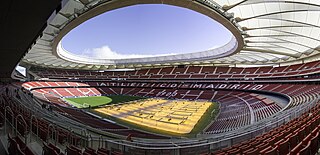
Metropolitano Stadium, also referred to as Cívitas Metropolitano for sponsorship reasons, is a stadium in Madrid, Spain. It has been the home stadium of Atlético Madrid since the 2017–18 season. It is located in the Rosas neighbourhood, in the San Blas-Canillejas district.

Braojos is a municipality of the autonomous community of Madrid in central Spain. It is located in the comarca of Sierra Norte.

Buitrago del Lozoya is a municipality of the autonomous community of Madrid in central Spain. It belongs to the comarca of Sierra Norte. The town is one of the few in the community that have maintained its walls, which are of Moorish origin and have been restored in the 15th century. It lies on a peninsula surrounded by the Lozoya river.

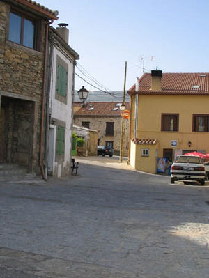
La Cabrera is a municipality in central Spain, around 56 km (35 mi) away from Madrid. La Cabrera belongs to the comarca called Sierra Norte de Madrid which is part of the wider autonomous Community of Madrid.

El Molar is a municipality of the Community of Madrid, Spain.

Venturada is a municipality of the Community of Madrid, Spain. In 2022 it had a population of 2445.

Somosierra is a municipality in the Community of Madrid, Spain, located at 83 km north of Madrid, in the mountain pass with the same name, at an elevation of 1433 metres above sea level, being the northernmost town of Community of Madrid. The Battle of Somosierra was fought here in 1808 during the Napoleonic Wars, and the Battle of Guadarrama was fought nearby in 1936 during the Spanish Civil War.

The Valsain Mountains are located in the Valsain Valley, on the northern slope of the Sierra de Guadarrama and in the municipality of Real Sitio de San Ildefonso, belonging to the province of Segovia.