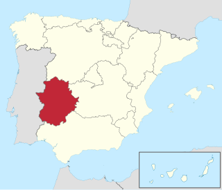
Extremadura is a landlocked autonomous community of Spain. Its capital city is Mérida, and its largest city is Badajoz. Located in the central-western part of the Iberian Peninsula, it is crossed from east to west by the Tagus and Guadiana rivers. The autonomous community is formed by the two largest provinces of Spain: Cáceres and Badajoz. Extremadura is bordered by Portugal to the west and by the autonomous communities of Castile and León (north), Castilla–La Mancha (east) and Andalusia (south).

The Community of Madrid is one of the seventeen autonomous communities of Spain. It is located in the centre of the Iberian Peninsula, and of the Central Plateau. Its capital and largest municipality is the City of Madrid, which is also the capital of the country. The Community of Madrid is bounded to the south and east by Castilla–La Mancha and to the north and west by Castile and León. It was formally created in 1983, based on the limits of the province of Madrid, which was until then conventionally included in the historical region of New Castile.

Castilla–La Mancha is an autonomous community of Spain. Comprising the provinces of Albacete, Ciudad Real, Cuenca, Guadalajara and Toledo, it was created in 1982. The government headquarters are in Toledo, and its largest city is Albacete.

The Manzanares is a river in the centre of the Iberian Peninsula, which flows from the Sierra de Guadarrama, passes through Madrid, and eventually empties into the Jarama river, which in turn is a right-bank tributary to the Tagus.
Móstoles is a municipality of Spain located in the Community of Madrid. With over 200,000 inhabitants, it is the region's second most populated municipality after Madrid. Móstoles was a small town for a long time, but expanded rapidly in the second half of the 20th century.
Soto del Real, whose former name was Chozas de la Sierra, is a town and municipality in the northern area of the autonomous Community of Madrid which had 8,294 inhabitants in 2009.

Colmenar Viejo is a town and municipality of about 48,614 inhabitants, located in the Community of Madrid, Spain, 30 kilometers north of Madrid on the M-607 motorway. It belongs to the comarca of Cuenca Alta del Manzanares.

The Sierra de Guadarrama is a mountain range forming the main eastern section of the Sistema Central, the system of mountain ranges along the centre of the Iberian Peninsula. It is located between the systems Sierra de Gredos in the province of Ávila, and Sierra de Ayllón in the province of Guadalajara.
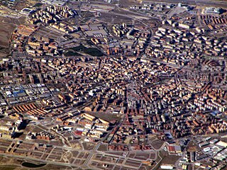
Fuenlabrada is a city and municipality of Spain located in the Community of Madrid. As of 2018, it has a population of 193,586, making it the region's fourth most populated municipality.

Manzanares el Real is a 8,936 inhabitant town in the northern area of the autonomous Community of Madrid. It is located at the foot of The Pedriza, a part of the Sierra de Guadarrama, and next to the embalse de Santillana.

Villarrubia de los Ojos is a municipality of Spain located in the province of Ciudad Real, Castilla–La Mancha. The municipality spans across a total area of 281.86 km2 and, as of 1 January 2020, it has a registered population of 9,762.
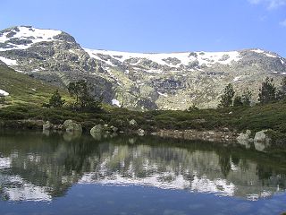
Sierra de Guadarrama National Park is a national park in Spain, covering nearly 34,000 hectares, the fifth largest in Spain's national parks system. The Guadarrama mountain range contains some ecologically valuable areas, located in the Community of Madrid and Castile and León. The law that regulates the recently approved national park was published in the BOE in June 26, 2013.

Torrelodones is a municipality in the northwest of the Autonomous Community of Madrid, Spain. It is situated 29 kilometers northwest from the city of Madrid. Because of its location between the Sierra de Guadarrama and the metropolitan area of the capital, it is linked to two districts in Madrid: the agricultural area of Guadarrama and the metropolitan area of Madrid.

In March and April 2009, an outbreak of a new strain of influenza commonly referred to as swine flu infected many people in Mexico and parts of the United States causing severe illness in the former. The new strain was identified as a combination of several different strains of Influenzavirus A, subtype H1N1, including separate strains of this subtype circulating in humans and in pigs. Spain was the first country in continental Europe to report cases of swine flu, in late April 2009.

Madrid is the capital and most populous city of Spain. The city has almost 3.6 million inhabitants and a metropolitan area population of approximately 6.7 million. It is the second-largest city in the European Union (EU), and its monocentric metropolitan area is the second-largest in the EU. The municipality covers 604.3 km2 (233.3 sq mi) geographical area.

The National Parks Autonomous Agency (OAPN) is an autonomous agency of the Spanish central government that manages the National Parks Network and the Spanish Biosphere Reserves Network, as well as mountains, farms and other patrimonial assets of its property. The agency was created on June 23, 1995 by the Agriculture Minister Luis María Atienza by merging two other agencies, the Institute for the Conservation of Nature (ICONA) and the National Institute for Agrarian Reform and Development (IRYDA).

The COVID-19 pandemic in Spain had its first case in the Community of Madrid on 25 February 2020.

La Maliciosa is one of the most important and highest mountains of the Sierra de Guadarrama, a mountainous formation belonging to the Sistema Central. It has an altitude of 2227m above sea level and is located in the northwest of the Community of Madrid, in Spain, rising between La Pedriza, which lies to the east, and La Barranca valley, which is on its western slope.

The Cuenca Alta del Manzanares Regional Park, created in 1985, is the natural space protected area with the largest extension in the Community of Madrid (Spain) and one of the most ecologically and scenically valuable. It is located in the northwest of the region and extends around the upper course of the Manzanares River, along 42 583 ha. Its main municipalities of reference are Manzanares el Real and Hoyo de Manzanares. Unesco declared it a Biosphere Reserve in 1992.

The Sierra de Hoyo or Sierra de Hoyo de Manzanares is a mountain chain located in the northwest of the Community of Madrid (Spain), near the Sierra de Guadarrama. Geologically it belongs to this mountainous formation, but there is a flat separation of about ten kilometers between the two. Its main municipality of reference is Hoyo de Manzanares, located on its southern slope, from which it takes its name.


