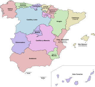
Murcia is a city in south-eastern Spain, the capital and most populous city of the Autonomous Community of the Region of Murcia, and the seventh largest city in the country, with a population of 447,182 inhabitants in 2018. The population of the metropolitan area was 689,591 in 2010. It is located on the Segura River, in the southeast of the Iberian Peninsula; it has a climate with hot summers, mild winters, and relatively low precipitation.

Valencia, officially València, is the capital of the autonomous community of Valencia and the third-largest city in Spain after Madrid and Barcelona, surpassing 800,000 inhabitants in the municipality. The wider urban area also comprising the neighbouring municipalities has a population of around 1.6 million. Valencia is Spain's third-largest metropolitan area, with a population ranging from 1.7 to 2.5 million depending on how the metropolitan area is defined. The Port of Valencia is the 5th-busiest container port in Europe and the busiest container port on the Mediterranean Sea. The city is ranked as a Gamma-level global city by the Globalization and World Cities Research Network.

Almería is a city in Andalusia, Spain, located in the southeast of Spain on the Mediterranean Sea, and is the capital of the province of the same name. Abd al-Rahman III founded the Alcazaba, which gave this city its name: al-Mariyyah. In the 10th and 11th centuries, it formed part of the Caliphate of Córdoba, and grew wealthy on trade and the textile industry, especially silk. It suffered many sieges and fell under Christian domination in 1489. In 1522, Almería was devastated by an earthquake and rebuilding and recovery did not really get underway until the 19th century. During the Spanish Civil War, the city was shelled by the German navy, and fell to Franco in 1939. It has since rebuilt its economy around vegetable production, with 100,000 acres of greenhouses, supplying much of Europe.
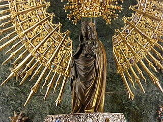
Our Lady of the Pillar is the name given to the Blessed Virgin Mary in the context of the traditional belief that Mary, while living in Jerusalem, supernaturally appeared to the Apostle James the Greater in AD 40 while he was preaching in what is now Spain. Those who adhere to this belief consider this appearance to be the only recorded instance of Mary exhibiting the mystical phenomenon of bilocation. Among Catholics, it is also considered the first Marian apparition, being unique due to having occurred while Mary was still living on Earth.

Calatayud is a municipality in the Province of Zaragoza, within Aragón, Spain, lying on the river Jalón, in the midst of the Sistema Ibérico mountain range. It is the second-largest town in the province after the capital, Zaragoza, and the largest town in Aragón other than the three provincial capitals. It is the seat of the comarca of Calatayud. Its population has been declining during the last decade due to migration.

El Puerto de Santa María, locally known as El Puerto, is a municipality located on the banks of the Guadalete River in the province of Cádiz, Andalusia. As of 2016, the city has a population of c. 88,184, of which some 50,000 live in the urban center, and the remainder in the surrounding areas.

Nochistlán is a city in the Mexican state of Zacatecas. Nuño Beltrán de Guzmán, on December 3, 1531, hired Cristóbal de Oñate to establish a village in Nochistlán; the village would be named Guadalajara to honor Guzmán for having been born in Guadalajara. Guadalajara was founded in Nochistlán on January 5, having as officials Cristóbal de Oñate, Sancho Ortiz de Zúñiga and Miguel Ibarra. They worked at this project for only 16 months and created the first layout of Guadalajara.

Las Rozas de Madrid is one of the largest townships and municipalities in the autonomous community of Madrid, Spain, with an area of 59 km². It is located 20 km northwest of the city of Madrid itself, on the A-6 freeway to A Coruña. Las Rozas is the beginning of this freeway, near the fork road M-505 to El Escorial, which marks the southern boundary of this 'comarca' or rural district.

Chiclana de la Frontera is a town and municipality in southwestern Spain, in the province of Cádiz, Andalucía, near the Gulf of Cádiz. It belongs to the association of municipalities of the Bay of Cádiz, the provincial capital of Cádiz, Jerez de la Frontera, San Fernando, El Puerto de Santa María, Puerto Real and Rota which form the third largest metropolitan area in Andalusia, behind Seville and Málaga, and the twelfth largest in Spain. It is located 20 kilometres south-east from Cádiz, and borders the municipalities of San Fernando and Puerto Real to the north. In 1877, the municipality's population was 11,677; in 2012, it was 81,473. It has a surface area is 203 square kilometres (78 sq mi) and a population density of 401 inhabitants / km2. The average elevation is 11 metres (36 ft) above sea level. The economy depends largely upon modern industry, especially salt processing and tourism, and the municipality is known for its beaches such as the 6 kilometres (3.7 mi) long Playa de la Barrosa, hotels and golf courses in the resort of Novo Sancti Petri. The municipality contains the largest number of hotel beds in the Province of Cádiz and the Costa de la Luz. The town's newspaper, Chiclana Información, is distributed on Saturday mornings.

Altagracia is a municipality in the Rivas Department of Nicaragua.

Envigado is a town southeast of Medellin, Colombia which belongs to the department of Antioquia.

The Puerta del Sol is a public square in Madrid, one of the best known and busiest places in the city. This is the centre of the radial network of Spanish roads. The square also contains the famous clock whose bells mark the traditional eating of the Twelve Grapes and the beginning of a new year. The New Year's celebration has been broadcast live since 31 December 1962 on major radio and television networks including Antena 3 and RTVE.
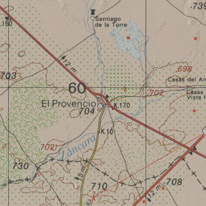
El Provencio is a small town and municipality in Cuenca, Spain with a population of 2,599 permanent inhabitants. It offers a vibrant nightlife, attracting visitors from nearby towns like Las Pedroñeras for 'Las Fiestas'. It has kept much of its medieval heritage and is on the newly planted trail that marks the route followed by the title character Miguel de Cervantes's novel Don Quixote. El Provencio sits in the extreme southern area of Cuenca, bordering both Albacete and Ciudad Real. The major highway linking the town to the rest of Spain is the National 301 Madrid - Cartagena, and it is about 81 kilometers south of Cuenca, the city.
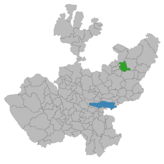
Jalostotitlán is a town and municipality located in the northeast corner of the state of Jalisco, Mexico, in a region known as Los Altos.

Centro is the central district of the city of Madrid, Spain. It is approximately 5.23 km² in size. It has a population of 149,718 people and a population density of 28,587/km².
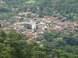
San Sebastián del Oeste is a town and municipality, located on the western part of Jalisco state, Mexico, between 20°39’45’’ - 21°02’30’’ N and 104°35’00’’ - 104°51’00’’ W, at a height of 1,480 metres (4,856 ft).
Jérica is a town in the Castellón province of Valencian Community, Spain. It is in the comarca (region) of Alto Palancia. Its population was 1,703 at the end of 2009.

Santa Maria del Campo is a town and municipality in the Province of Burgos, Spain. The village is in the wine region known as Ribera del Arlanza, 22 km from Lerma.
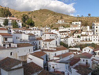
El Borge is a town and municipality in the province of Málaga, part of the autonomous community of Andalusia in southern Spain. It is located in the comarca of Axarquía. The municipality is situated approximately 24 kilometers from Vélez-Málaga, 28 from the provincial capital of Málaga and 567 km from Madrid. It has a population of approximately 1,000 residents. The natives are called Borgeños.
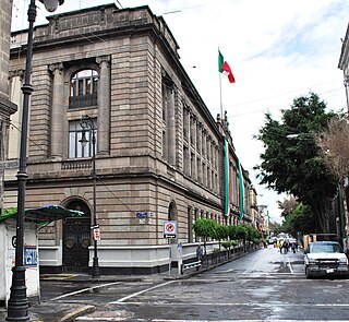
The Secretariat of Public Education Main Headquarters building is on the northeast corner of San Ildefonso and República de Argentina streets in the historic center of Mexico City, and used to be part of the largest and most sumptuous convents in New Spain. It was secularized in the 19th century and then taken over by the then-new Secretariat of Public Education after the Mexican Revolution in the early 20th century. The new agency did extensive remodeling work on the building, including covering nearly all the walls of the two inner courtyards with murals. These murals include Diego Rivera’s first large-scale mural project, which he completed in 1928.