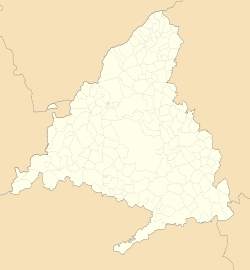
The Community of Madrid is one of the seventeen autonomous communities of Spain. It is located in the centre of the Iberian Peninsula, and of the Central Plateau. Its capital and largest municipality is the City of Madrid, which is also the capital of the country. The Community of Madrid is bounded to the south and east by Castilla–La Mancha and to the north and west by Castile and León. It was formally created in 1983, in order to address the particular status of the City of Madrid as the national capital city and in urban hierarchy. Its limits are those of the province of Madrid, which was until then conventionally included in the historical region of New Castile.

San Lorenzo de El Escorial, also known as El Escorial de Arriba, is a town and municipality in the Community of Madrid, Spain, located to the northwest of the region in the southeastern side of the Sierra de Guadarrama, at the foot of Mount Abantos and Las Machotas, 47 kilometres (29 mi) from Madrid. It is head of the eponymous judicial party. The settlement is popularly called El Escorial de Arriba, to differentiate it from the neighbouring village of El Escorial, also known as El Escorial de Abajo.

The Manzanares is a river in the centre of the Iberian Peninsula, which flows from the Sierra de Guadarrama, passes through Madrid, and eventually empties into the Jarama river, which in turn is a right-bank tributary to the Tagus.

Tres Cantos is a municipality of Spain located in Community of Madrid.
Pozuelo de Alarcón is a municipality in the Community of Madrid, Spain. Bordering the Moncloa-Aravaca district of Madrid proper to its west, Pozuelo de Alarcón is surrounded by large Mediterranean pine-tree forests: the Casa de Campo, the Monte del Pardo, and the Monte del Pilar. As of 2022, it ranks as the wealthiest municipality in Spain. La Finca, an isolated luxury residential area known by its affluent residents, most notably football players, lies within the municipality bounds.
Móstoles is a municipality of Spain located in the Community of Madrid. With over 200,000 inhabitants, it is the region's second most populated municipality after Madrid. Móstoles was a small town for a long time, but expanded rapidly in the second half of the 20th century.

Montoro is a municipality of Spain belonging to the province of Córdoba, Andalusia. Housing lies on a bend of the river Guadalquivir, which envelopes from West, North, and East.

The Sierra de Guadarrama is a mountain range forming the main eastern section of the Sistema Central, the system of mountain ranges along the centre of the Iberian Peninsula. It is located between the systems Sierra de Gredos in the province of Ávila, and Sierra de Ayllón in the province of Guadalajara.
Fuenlabrada is a city and municipality of Spain located in the Community of Madrid. As of 2018, it has a population of 193,586, making it the region's fourth most populated municipality.
Collado Villalba is a municipality of the Community of Madrid, in central Spain. It is located 40.3 kilometres north-west of the city of Madrid, at an altitude of 917 meters above sea level. It has a population of 64,263 (2022), with a population density of about 2,400 per km2. Collado Villalba has a hot summer Mediterranean climate.
Collado Mediano is a town and municipality in the north-west of the Community of Madrid, Spain. It had a population of 6,610 in 2011 and is located 48 km from Madrid. The municipality covers an area of 22.57 km2. Located near the Sierra de Guadarrama, it lies at 1,032 metres above sea level.

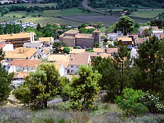
Colmenarejo is a Spanish town and municipality in the Community of Madrid, located in the northwest of the region, in the foothills of the Sierra de Guadarrama, 899 meters high and 37 kilometers away from the capital. It is bordered to the north by El Escorial, to the east by Galapagar, to the south by Villanueva del Pardillo and to the west by Valdemorillo. Its only road access is the M 510, from Galapagar or from Valdemorillo. It has in its municipality with the east bank of the reservoir of Valmayor, second in capacity of the Region of Madrid, with the third Campus of the University Carlos III of Madrid and with an attractive natural environment, where you can go for walks with a bicycle, within the Regional Park of the middle course of the Guadarrama River and its surroundings, in which stand out the holm oaks and pastures of cattle use dotted with junipers, ash trees and gall oaks.

El Espinar is a Spanish town council located 65 kilometres away from Madrid city centre, in the northern slope of the Sistema Central mountain range. It belongs to the province of Segovia and to the autonomous Community of Castile and León.
Hoyo de Manzanares is a municipality of the Community of Madrid, Spain, and is located on the northwestern side of the Community of Madrid and to the south of the Sierra de Guadarrama.

Navacerrada is a municipality of the Community of Madrid, Spain. It lies at an elevation of 1,203 metres (3,947 ft) on the Reservoir Navacerrada and the entry of "Valle de la Barranca" in the Sierra de Guadarrama.

Villanueva del Pardillo is a municipality and Spanish town of the Community of Madrid, situated 26 kilometers from the capital of Spain and nestled in the natural environment of the Cuenca del Guadarrama. It borders the municipalities of Majadahonda, Las Rozas de Madrid, Villanueva de la Cañada, Galapagar, Colmenarejo and Valdemorillo.

The Madrid–Asturias high-speed rail line connects the city of Madrid with the autonomous community of Asturias and was inaugurated on 29 November 2023. The line is built to standard gauge and gauge changers are provided at strategic points to allow interchange with older Spanish railways which were built to Iberian gauge.

Madrid is the capital and most populous city of Spain. The city has almost 3.4 million inhabitants and a metropolitan area population of approximately 7 million. It is the second-largest city in the European Union (EU), and its monocentric metropolitan area is the second-largest in the EU. The municipality covers 604.3 km2 (233.3 sq mi) geographical area. Madrid lies on the River Manzanares in the central part of the Iberian Peninsula at about 650 meters above mean sea level. The capital city of both Spain and the surrounding autonomous community of Madrid, it is also the political, economic, and cultural centre of the country. The climate of Madrid features hot summers and cool winters.
Oterulo del Valle is a town located in the municipality of Rascafría, in the Community of Madrid, Spain. Oterulo del Valle was an independent town until 1975 and in 2021, had a population of 138 people.
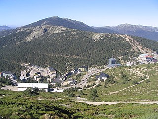
The Navacerrada Pass is a mountain pass in the Guadarrama Mountains, in the centre of the Iberian Peninsula.