Barranquitas is a small mountain town and municipality located in the Cordillera Central region of Puerto Rico, south of Corozal and Naranjito; north of Coamo and Aibonito; west of Comerío and Cidra; and east of Orocovis. Barranquitas is spread over 6 barrios and Barranquitas Pueblo. It is part of the San Juan-Caguas-Guaynabo Metropolitan Statistical Area.

Camuy is a town and municipality of Puerto Rico, bordering the Atlantic Ocean, north of Lares and San Sebastián; east of Quebradillas; and west of Hatillo. Camuy is spread over 12 barrios and Camuy Pueblo. The town celebrated its 200th anniversary in 2007.

Isabela is a town and municipality of Puerto Rico located in the north-western region of the island, north of San Sebastián; west of Quebradillas; and east of Aguadilla and Moca. It is named in honor of Isabella I of Castile. Isabela is spread over 13 barrios and Isabela Pueblo, which is the downtown area and administrative center. It is a principal part of the Aguadilla-Isabela-San Sebastián Metropolitan Statistical Area.
San Sebastián is a town and municipality of Puerto Rico located in the northwestern region of the island, south of Isabela, Quebradillas and Camuy; north of Las Marías; east of Moca and Añasco; and west of Lares. San Sebastián is spread over twenty-four barrios and San Sebastián Pueblo. It is a principal city of the Aguadilla-Isabela-San Sebastián Metropolitan Statistical Area.
Quebradillas is a town and municipality of the island of Puerto Rico located in the north-western shore bordering the Atlantic Ocean, north of San Sebastián; east of Isabela; and west of Camuy. Quebradillas is spread over seven barrios and Quebradillas Pueblo. It is part of the San Juan-Caguas-Guaynabo Metropolitan Statistical Area.

Scouting in Puerto Rico was introduced in the 1920s, and has been serving both boys and girls in the island since then. The Boy Scouts of America (BSA), serves both boys and girls in different programs, while the Girl Scouts of the USA serves only girls in various levels.

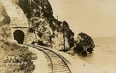
Rail transport in Puerto Rico currently consists of a 10.7-mile (17.2 km) passenger metro system in the island's metropolitan area of San Juan. Its history can be traced back to the mid-19th century with the construction of a limited passenger line in Mayagüez. Between the late 19th and early 20th centuries, Puerto Rico's rail transport system expanded significantly, becoming one of the largest rail systems in the Caribbean at the time thanks to an economic boom in agriculture industries, especially the sugar cane industry. The rail system was expanded to include passenger travel with a direct line from the island's northern capital of San Juan to the western and southern cities and towns, greatly improving travel and communication within the island. However, the entire system was soon overshadowed by the arrival of the automobile, and by the 1950s was completely abandoned. Small remnants of this system still exist in some parts of Puerto Rico, some conserved for tourism purposes.

Guajataca River is a river in Lares, Puerto Rico. It is located on the northwest coast of the island. It flows from the south and drains into the Atlantic Ocean. The name was given by the original Taino inhabitants prior to the arrival of Christopher Columbus.

Guajataca Lake, or Lago Guajataca, is a reservoir of the Guajataca River created by the Puerto Rico Electric Power Authority in 1929. It is located between the municipalities of San Sebastián, Quebradillas, and Isabela in Puerto Rico, and receives most of its water from the Rio Guajataca and Rio Chiquito de Cibao rivers. The lake primarily functions as a water reservoir as well as for recreational activities such as boating and fishing. Various species of fish such as peacock bass, largemouth bass, sunfish, perch, catfish, tilapia and threadfin shad can be found in the lake. The Guajataka Scout Reservation partially borders the southern portion of the lake. The dam at Guajataca Lake experienced a structural failure on September 22, 2017, due to the hit from Hurricane Maria.

Puerto Rico Highway 2 (PR-2) is a road in Puerto Rico that connects the cities of San Juan and Ponce. At 156 miles (230 km) long, it is Puerto Rico's longest singled-signed highway.

The Puente Blanco is a historic railway bridge that spans hundred and fifty feet deep and thirty six metres wide gorge across the Quebrada Mala Canyon, near Quebradillas, Puerto Rico. The bridge is the only reinforced concrete bridge in the area and the highest of its kind in Puerto Rico. It was built in 1922 by the American Railroad Company to replace a 1907 steel bridge as part of the construction of the national railway system that connected the island during the first half of the twentieth century. It was built on a concrete platform that held the existing steel bridge without interrupting the passage of the railway. The new bridge could hold two locomotives of 84 tons each. It was designed by Etienne Totti from Yauco who was the head engineer for the company. The bridge was restored by the municipality of Quebradillas, unfortunately as part of the repair the base was widened altering the character of the structure and hindering the view of the bridge. It was listed on the National Register of Historic Places in 1984.

Cacao is a barrio in the municipality of Quebradillas, Puerto Rico. Its population in 2010 was 4,663. One of the communities within this barrio is named Cacao Community and in 2010 had a population of 1,001.
Heriberto Vélez Vélez is a Puerto Rican politician and the current mayor of Quebradillas. Vélez is affiliated with the Popular Democratic Party (PPD) and has served as mayor since 2005. Has a bachelor's degree in Education, with a concentration in mathematics from the Pontifical Catholic University of Puerto Rico.

Guajataca is a barrio in the municipality of Quebradillas, Puerto Rico. Its population in 2010 was 1,611.

Puerto Rico Highway 113 (PR-113) is a rural road that travels from Isabela, Puerto Rico to Quebradillas. It begins at downtown Isabela and ends at its intersection with PR-119 near Guajataca Lake.

The Northern Karst is a limestone karst landscape located in the northern part of Puerto Rico. A karst is a topographical zone formed by the dissolution of soluble porous rocks, such as limestone, with features such as mogotes, canyons, caves, sinkholes, streams and rivers, all of which are common on this region of the island. Some of the island's main rivers, including its longest, traverse the karst and form some of the most distinctive Puerto Rican geographical features such as the Camuy caverns. Many of these rivers feed into and are important in the formation of many marshy areas such as the Caño Tiburones wetlands.

Guajataca State Forest is one of the 20 forests that make up the public forest system of Puerto Rico. The Guajataca Forest is located in the northwestern part of Puerto Rico, along the Northern Karst zone in the municipality of Isabela and municipality of Quebradillas, and is near Camuy and San Sebastián. The forest is renowned for its ecological diversity, the mogotes and karstic formations, and its numerous caves and canyons. It also has the largest trail system of any Puerto Rican state forest.