Guam Highway 2

Last updated • a couple of secsFrom Wikipedia, The Free Encyclopedia

Guam route marker 2.svg

Guam Highway 2
Route information
Maintained by Guam Department of Public Works
Major junctions
South endGuam route marker 4.svg GH-4 in Umatac
 Guam route marker 12.svg GH-12 in Agat
North endGuam route marker 2A.svg GH-2A in Santa Rita/Naval Base Guam Gate 2
Highway system

Guam Highways

Guam route marker 1.svg GH-1 GH-3 Guam route marker 3.svg

Guam Highway 2 is one of the primary automobile routes in the United States territory of Guam.

Contents

Route description

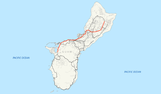
The route runs in a south to north direction, from the Magellan Monument in the southern community of Umatac in a general northward direction to the community of Santa Rita, where it meets Highway 2A (which connects to Guam Highway 1 Marine Corps Drive) and Gate 2 of Naval Base Guam. [1]

Major intersections

LocationmikmDestinationsNotes
Umatac Guam route marker 4.svg GH-4 Southern terminus
Agat Guam route marker 12.svg GH-12
Santa Rita Guam route marker 2A.svg GH-2A Northern terminus
1.000 mi = 1.609 km; 1.000 km = 0.621 mi

Suffixed route

Guam route marker 2A.svg

Guam Highway 2A
Location Santa Rita, Guam

Guam Highway 2A (GH-2A) connects GH-2 to GH-1 in Santa Rita, junctioning with GH-5 along the way.

Related Research Articles

Colorado State Highway 3 highway in Colorado

State Highway 3 is a short north–south state highway located in and near the city of Durango, in the county of La Plata in the U.S. State of Colorado, United States. It follows the former alignment of U.S. Route 160 (US 160) and US 550 south of downtown, lying across the Animas River from the modern highway constructed about 1980.

Guam Highway 4 (GH-4) is one of the primary automobile highways in the United States territory of Guam.

New Jersey Route 63 highway in New Jersey

Route 63 is a short, 3.09-mile (4.97 km) long state highway in Hudson and Bergen Counties in New Jersey. The route is known as Bergen Boulevard and concurrent with County Route 501 for most of its alignment. The southern terminus is at Kennedy Boulevard and County Route 501 in the community of North North Bergen. The route crosses the county line and heads along the boulevard through the communities of Ridgefield, Palisades Park, and Fort Lee before reaching its northern terminus at an interchange with U.S. Route 1-9 and 46 in Fort Lee.

Guam Highway 3 (GH-3) is one of the primary automobile highways in the United States territory of Guam.

Guam Highway 6 (GH-6) is one of the primary automobile highways in the United States territory of Guam. It is known alternately as Spruance Drive and Halsey Drive: both named for noteworthy US Navy Admirals that served in the Pacific Ocean theater of World War II: Raymond A. Spruance and William Halsey Jr., respectively.

Guam Highway 7 (GH-7) is one of the primary automobile highways in the United States territory of Guam.

Guam Highway 8 (GH-8) is one of the primary automobile highways in the United States territory of Guam.

Guam Highway 11 (GH-11) is one of the primary automobile highways in the United States territory of Guam.

Guam Highway 9 (GH-9) is one of the primary automobile highways in the United States territory of Guam.

Guam Highway 10 (GH-10) is one of the primary automobile highways in the United States territory of Guam.

Guam Highway 16 (GH-16), also named Army Drive, is one of the primary automobile highways in the United States territory of Guam.

Guam Highway 10A (GH-10A) is one of the primary automobile highways in the United States territory of Guam.

Guam Highway 17 (GH-17) is one of the primary automobile highways in the United States territory of Guam.

Guam Highway 18 (GH-18) is one of the primary automobile highways in the United States territory of Guam.

Guam Highway 12 (GH-12) is one of the primary automobile highways in the United States territory of Guam.

Guam Highway 15 (GH-15) is one of the primary automobile highways in the United States territory of Guam.

Guam Highway 14 (GH-14) is one of the primary automobile highways in the United States territory of Guam.

Guam Highway 27 (GH-27), also known as Hamburger Highway or Harmon Loop Road, is a short highway in the United States territory of Guam. The highway runs in an east–west direction from a junction with GH-16 to a junction with GH-1, and is located almost entirely in the southern region of the city of Dededo. The highway gets its name from the fact that it provides access to a large McDonald's restaurant located at the intersection with GH-16.

References

  1. Guam (Map). NS.gov.gu. Retrieved 2008-05-24.

Route map: Google

KML file (edithelp)
KML is from Wikidata