Interstate 195 (I-195), also known as the Saco Industrial Spur, is a short auxiliary Interstate Highway running 2.41 miles (3.88 km) in eastern York County, Maine. The highway, located entirely in the city of Saco, is a nominally east–west route that provides access to Downtown Saco and the resort town of Old Orchard Beach from Interstate 95. The western terminus of I-195 is at a trumpet interchange with the Maine Turnpike in central Saco. The route has numbered interchanges with Industrial Park Road, U.S. Route 1, and Maine State Route 5 before terminating at an at-grade intersection with SR 5 near the border between Saco and Old Orchard Beach.

State Road 3 (SR 3) in the U.S. state of Indiana is a discontinuous state highway running through eastern Indiana from near the Ohio River to near the Michigan state line. The southernmost terminus is at SR 62 in Charlestown, and the northernmost terminus is at SR 120 near Brighton.

State Road 69 (SR 69) is a part of the Indiana State Road system that runs between Hovey Lake Fish and Wildlife Area and Griffin in US state of Indiana. The 35.07 miles (56.44 km) of SR 69 that lie within Indiana serve as a major conduit. Some of the highway is listed on the National Highway System. Various sections are urban two-lane highway, three-lane highway and rural two-lane highway. The highway passes through residential, industrial and commercial properties.
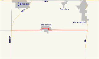
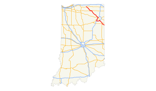
State Road 128 is a state road in the central part of the U.S. state of Indiana. Running for about 10.865 miles (17.486 km) in a general east–west direction, connecting Frankton and rural Madison County. The western terminus is at a junction with SR 13 and SR 37, south of Elwood. The eastern terminus is at an intersection with SR 9, south of Alexandria. The highway passes through mostly agricultural and residential properties, as a two-lane roadway. SR 128 was originally introduced in the late 1930s or early 1940s routed along its modern routing. The entire roadway was paved in the late 1960s.
State Road 25 is a highway in the U. S. state of Indiana. Although it is designated a north–south road, in practice it travels generally northeast from its southern terminus at State Road 32 to its northern terminus at State Road 15 in Warsaw.

State Route 220 is an east–west state highway in the south central portion of the U.S. state of Ohio. Its western terminus is at SR 772 about 8.25 miles (13.28 km) west of Waverly, and its eastern terminus is at the SR 32/SR 124 concurrency 3 miles (4.8 km) east of Piketon. The entire route is in Pike County.

Guam Highway 1 (GH-1), also known as Marine Corps Drive, is one of the primary automobile routes in the United States territory of Guam. It runs in a southwest-to-northeast direction, from the main gate of Naval Base Guam in the southwestern village of Santa Rita in a northeasterly direction to the main gate of Andersen Air Force Base in the village of Yigo. It passes through Guam's capital, Hagåtña, as well as intersecting other territorial highways. The highway runs through tropical forest, urbanized commercial areas, and residential neighborhoods. The US military upgraded and extended the road starting in 1941. Construction ceased with the Japanese invasion in December 1941 and resumed after the Second Battle of Guam in 1944. The highway was formally dedicated to the U.S. Marine Corps by the governor in 2004.
Pennsylvania Route 214 is an 11.3-mile-long (18.2 km) state highway located in York County, Pennsylvania. The western terminus is at PA 616 in Seven Valleys. The eastern terminus is at PA 74 in Dallastown. PA 214 is a two-lane undivided road that runs through rural areas to the south of York. Along the way, the route passes through Loganville, where it has indirect access to Interstate 83 (I-83). PA 214 was designated between PA 616 in Seven Valleys and PA 74 in Dallastown in 1961. In 2009, the route was shifted to bypass West Ore Street through the western portion of Loganville to the north in order to provide more direct access to I-83.
Guam Highway 4 (GH-4) is one of the primary automobile highways in the United States territory of Guam.
U.S. Route 33 (US 33) is part of the United States Numbered Highway System that runs from Richmond, Virginia to Elkhart of the US state of Indiana. In Indiana, it is a state road that enters the state at the Ohio state line between Willshire, Ohio, and Pleasant Mills, Indiana. The 106.217 miles (170.940 km) of US 33 that lie within Indiana serve as a major conduit. All of the highway is listed on the National Highway System. Various sections are rural two-lane highway, urbanized four-lane divided expressway and the Lincoln Highway. The northernmost community along the highway is Elkhart. The highway ends at an interchange in southern Elkhart after serving the northeastern region of Indiana. US 33 passes through farm fields and urban areas.

U.S. Route 231 in Indiana is a main north–south highway in the western part of the state. The southern terminus of US 231 is at the Kentucky state line and the northern terminus is at US 41 just south of St. John. The highway is a mixture of expressway and two-lane roadway. The expressway is mainly in southern Indiana and around the Lafayette area, with the rest mainly being two-lanes.
Guam Highway 3 (GH-3) is one of the primary automobile highways in the United States territory of Guam.
Guam Highway 5 (GH-5) is one of the primary automobile highways in the United States territory of Guam.
Guam Highway 6 (GH-6) is one of the primary automobile highways in the United States territory of Guam. It is known alternately as Spruance Drive and Halsey Drive: both named for noteworthy US Navy Admirals that served in the Pacific Ocean theater of World War II: Raymond A. Spruance and William Halsey Jr., respectively.
Guam Highway 7 (GH-7) is one of the primary automobile highways in the United States territory of Guam.
Guam Highway 8 (GH-8) is one of the primary automobile highways in the United States territory of Guam.
Guam Highway 10A (GH-10A) is one of the primary automobile highways in the United States territory of Guam.
Guam Highway 18 (GH-18) is one of the primary automobile highways in the United States territory of Guam.
Guam Highway 15 (GH-15) is one of the primary automobile highways in the United States territory of Guam.
Guam Highway 14 (GH-14) is one of the primary automobile highways in the United States territory of Guam.
