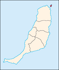
Lobos is a small island of the Canary Islands (Spain) located just 2 kilometres north of the island of Fuerteventura. It belongs to the municipality of La Oliva on the island of Fuerteventura. It has an area of 4.68 square kilometres (1.8 sq mi). It has been a nature reserve since 1982.

Paracas National Reserve is a protected area in the region of Ica, Peru and protects desert and marine ecosystems for their conservation and sustainable use. There are also archaeological remains of the Paracas culture inside the reserve.

Isla Espíritu Santo is an uninhabited island in the Gulf of California, off the Mexican state of Baja California Sur. It is separated from Isla Partida by a narrow canal.

Pingüino de Humboldt National Reserve is a nature reserve located a short distance off the coast of mainland Chile. It consists of three islands: Chañaral, Damas, and Choros. It is located about 100 km (62 mi) north of La Serena in the Coquimbo Region of Chile and has a total area of 859.3 hectares. Coastal communities of Caleta Chañaral, Chañaral de Aceituno, and Punta de Choros are nearby. The reserve is an important breeding site for the Humboldt penguin, for which it is named, and is a habitat for sea lions and bottlenose dolphins, chungungos, sea turtle, whale, albatross and cormorant. Aside from dolphins, local cetacean diversity includes migratory rorquals such as blue, fin, and humpback whales, and sperm whales.

The Isla de Lobos is a small island located about 8 kilometres (5.0 mi) southeast of Punta del Este (Uruguay) in the Atlantic Ocean. An islet lies east of the island.

Campo de Cartagena is a natural region (comarca) located in the Region of Murcia, in Spain. For administrative purposes, it is also known as Comarca del Campo de Cartagena or Comarca de Cartagena. It is located in the southeast of the Iberian Peninsula, forming a plain which extends from the Sierra de Carrascoy to the Mediterranean. The capital city is Cartagena, the most important Naval Base of the Spanish Navy in the Mediterranean Sea.

Lobos de Tierra is a Peruvian island situated 19 km from the mainland close to the Illescas Peninsula and the boundary between the departments of Piura and Lambayeque regions. Its area is 16 km2, its approximate length is 10 km, and its approximate width is 3 km. Around the island there are several islets such as El León and Albatros. It is part of Peru’s Guano Islands, Islets, and Capes National Reserve System.
San Pedro Mártir is the name of an island of Mexico, located in the Gulf of California, about halfway between the coast of Baja California and Sonora. San Pedro Mártir is located in the center of the Gulf of California and is the most remote island in the Sea of Cortez. It is located 51 km from Baja California and 53 km off the coast of Sonora. The island is 2 km long and 1.5 km maximum width, with a total of 2,729 km2 of total area. The island is uninhabited by humans and is 60 km from Bahía Kino, the nearest city in the state of Sonora on the west coast.
Protected areas of Panama include:

The Guañape Islands form an island group off the coast of northern Peru. The group consists of four islands: Isla Guañape Norte, Isla Guañape Sur, Islotes Cantores, and Islotes Los Leones.

Mona and Monito Islands Nature Reserve consists of two islands, Mona and Monito, in the Mona Passage off western Puerto Rico in the Caribbean. Mona and Monito Islands Nature Reserve encompasses both land and marine area, and with an area of 38,893 acres it is the largest protected natural area in the Commonwealth of Puerto Rico. Much like the Galapagos Islands in the Pacific Ocean, the Mona and Monito Islands reserve represents a living laboratory for archaeological, biological, geological, oceanographical and wildlife management research.

Isla Verde Reef is a reef that surrounds Isla Verde Key, located off the coast of Punta del Medio in Isla Verde, Carolina, in the Atlantic coast of Puerto Rico. The Isla Verde Reef, protected as the Isla Verde Reef Marine Reserve, forms part of a larger reef system that extends from Punta Maldonado in Piñones, Loíza to the San Juan Islet. This is one of the three designated marine reserves in Puerto Rico, the other two being the Desecheo Coastal Waters and Tres Palmas marine reserves off the western coast of Puerto Rico, and the only one that protects a coral reef ecosystem on an urban area. The reserve is home to endangered species such as manatees, sea turtles and federally protected coral species such as the elkhorn coral. The coral reef is also an ideal place for fish spawning which is important for the fishing industry of the region. The Isla Verde Reef is protected through community organizations such as Arrecifes Pro Ciudad, and public organisms such as Para la Naturaleza, with support from academic institutions such as the University of Puerto Rico at Bayamón.
Nature Reserve of Puerto Rico is a title and special designation given by the upper house of the Legislative Assembly of Puerto Rico to specific natural areas or features throughout the territory. All nature reserves in Puerto Rico are protected by Puerto Rico Law #150, first approved on August 8, 1988, better known as the Puerto Rico Natural Heritage Program Act that seeks to protect the natural resources of the island for the purpose of natural preservation and tourism. These are managed by different agencies within the Puerto Rico Department of Natural and Environmental Resources, public-private partnerships such as the Conservation Trust of Puerto Rico and its management unit Para la naturaleza, and other grassroots and community institutions and programs.
Don Martin Island, also known as Don Martin Islet or San Martín Island, is an island belonging to Peru located in the Pacific Ocean, off the coast of the department of Lima. It is located one kilometer southwest of Vegueta Point and has an area of approximately 16.50 hectares. The island is very important because it is a guano deposit and the habitat of numerous species of marine birds, which have found a feeding, breeding and resting area on Don Martín Island. For this reason, in 2009 the island was protected by law within the National Reserve System of Islands, Islets and Puntas Guaneras, a natural reserve that protects and preserves representative samples of the biological diversity of the marine-coastal ecosystems of Peru.

The Pachacámac Islands, also known as Cavillaca Islands or as Whale Islands, are a group of islands located in the Pacific Ocean, off the coast of Lurín District, in Lima Province, Peru. Its formed by two main islands and three islets.
Callao Bay is a bay located off the coast of Callao, Peru. The islands of San Lorenzo and El Frontón are located to its west.

Islote Lobos National Park is a protected natural area located over the San Matías Gulf on the Atlantic coast of Río Negro province, about 50 km from the town of Sierra Grande and adjacent to the town of Playas Doradas, San Antonio department, in Argentine Patagonia. The park is a coastal strip of approximately 20 km that includes a complex of six rocky promontories close to the shore: Lobos, La Pastosa, Ortiz Norte, Ortiz Sur, Redondo, and de los Pájaros.

The La Cordillera Reef Nature Reserve, also known as the Reserva Natural Cayos de la Cordillera, is a nature reserve located 1.5 nautical miles off the coast of the barrio of Cabezas in the municipality of Fajardo in northeastern Puerto Rico. It consists of a small chain of cays, reefs, and islets, collectively known as La Cordillera or Cayos de la Cordillera. From west to east, the archipelago comprises Las Cucarachas islets, Los Farallones islets, Icacos cay, Ratones cay, Lobos cay, Palominos island, Palominitos island, La Blanquilla cay and islets, Diablo cay, Hermanos reefs, and Barriles reefs. The nature reserve covers about 18 nautical miles and almost 30,000 acres between cape Las Cabezas de San Juan in Cabezas, Fajardo and the Spanish virgin island of Culebra.

Lobos de Afuera is a small, rocky Peruvian archipelago lying in the eastern Pacific Ocean some 54 km off the coast of the Pimentel District of Peru. The archipelago is about 4.8 km long, north-west to south-east, and 3.2 km wide. It comprises two main islands, Independencia and Cachimbo, separated by a channel 36 m wide, along with several reefs, rocks and islets. It is part of Peru's Guano Islands, Islets, and Capes National Reserve System, and has a history of guano extraction.

