Guards Club Island

Last updated

Guards Club Island (upstream side) showing Guards Club Island Bridge and Guards Club Park to the right Guards Club Island looking downstream (Nancy).JPG
Guards Club Island (upstream side) showing Guards Club Island Bridge and Guards Club Park to the right
Guards Club Island (downstream side) and Maidenhead Railway Bridge with Maidenhead Bridge beyond Maidenhead Railway Bridge and Guards Club Island (Nancy).JPG
Guards Club Island (downstream side) and Maidenhead Railway Bridge with Maidenhead Bridge beyond
Guards Club Island
BSicon uCONTfa.svg
River Thames
BSicon uexSTR+l.svg
BSicon uexSTRq.svg
BSicon uexSTRq.svg
BSicon POINTERg@fq.svg
BSicon ueFABZgr+r.svg
Fleet River
BSicon uexSTR.svg
BSicon uSKRZ-Au.svg
A3094 road bridge
BSicon uexSTR.svg
BSicon uWEIRr.svg
BSicon uexSTR+r.svg
weir
BSicon uexSTR.svg
BSicon uexSTR+l.svg
BSicon uexABZq+l.svg
BSicon ueABZgr.svg
BSicon ueWHRF.svg
Hedsor Wharf
BSicon uexSTR.svg
BSicon uxWEIRg.svg
BSicon uexSTR.svg
BSicon uSTR.svg
BSicon uSTR.svg
weir
BSicon uexSTR.svg
BSicon uexSKRZ-Eu.svg
BSicon uSKRZ-Eu.svg
BSicon uSTR.svg
bridges
BSicon uexSTR.svg
BSicon uexSTR.svg
BSicon uxWEIRg.svg
BSicon uLock5.svg
BSicon uSTR.svg
Cookham Lock
BSicon uexSTR.svg
BSicon uexSTR.svg
BSicon uxABZg+l.svg
BSicon uABZqr.svg
BSicon uSTRr.svg
BSicon uexSTR.svg
BSicon uexSTRl.svg
BSicon ueABZg+r.svg
Formosa Island
BSicon POINTERg@fq.svg
BSicon uexSTR.svg
BSicon uSTR.svg
Strand Water
BSicon uexFABZgl+l.svg
BSicon uexSTRq.svg
BSicon POINTERg@fq.svg
BSicon ueFABZgr+r.svg
White Brook
BSicon POINTERg@fq.svg
BSicon uexSTR.svg
BSicon uSTR.svg
Maidenhead Ditch
BSicon uexSTR.svg
BSicon ueABZgl.svg
BSicon uexSTRq.svg
BSicon uexSTR+r.svg
Mill Race
BSicon uexSTR.svg
BSicon uSTR+l.svg
BSicon uxABZgr.svg
BSicon uexSTR.svg
BSicon uexSTR.svg
BSicon uSTR.svg
BSicon uxWEIRr.svg
BSicon uCANOE.svg
BSicon uexSTR+r.svg
BSicon uexSTR.svg
Kayaking
BSicon uexSTR.svg
BSicon uSTR.svg
BSicon ueMILL.svg
BSicon uexSTR.svg
BSicon uexSTR.svg
Ray Mill
BSicon uexSTR.svg
BSicon uLock5.svg
BSicon uexABZg+l.svg
BSicon uexSTRr.svg
BSicon uexSTR.svg
Boulter's Lock
BSicon uexSTR.svg
BSicon uSTRl.svg
BSicon uxABZg+r.svg
BSicon uexSTR.svg
BSicon uexSTR.svg
BSicon ueABZg+l.svg
BSicon ueMILL.svg
BSicon uexSTRq.svg
BSicon uexABZgr.svg
Taplow mill
BSicon uexSTR.svg
BSicon uSTR.svg
BSicon uxWEIRg.svg
Jubilee River --
BSicon uexSTR.svg
BSicon uSTR.svg
BSicon uexSTRl.svg
BSicon uexdCONTfq.svg
-- (to Old Windsor Lock)
BSicon uexSKRZ-Eu.svg
BSicon uSTRl.svg
BSicon uSTRq.svg
BSicon uSTR+r.svg
Ray Mill Road West
BSicon uexSTR.svg
BSicon uISLAND.svg
Grass Eyot
BSicon uexSTR.svg
BSicon uISLAND.svg
Bridge Eyot
BSicon uexFABZgl+l.svg
BSicon POINTERf@g.svg
BSicon uexSTR+r.svg
BSicon uSTR.svg
Moor Cut
BSicon uexSKRZ-Au.svg
BSicon RAq.svg
BSicon RAq.svg
BSicon uSKRZ-Au.svg
A4 Bath Road
BSicon uexSKRZ-Yu.svg
BSicon uexSTR.svg
BSicon uSTR.svg
High St.(Chapel Arches)
BSicon uSKRZ-Yu.svg
BSicon uexSTR.svg
BSicon uSTR.svg
York Road
BSicon uSTR.svg
BSicon uexSTR.svg
BSicon uSPLa.svg
Guards Club Island
BSicon dCONTgq.svg
BSicon umKRZu.svg
BSicon uxmKRZu.svg
BSicon STRq.svg
BSicon hSTRa@fq.svg
BSicon MSTRq.svg
BSicon hSTReq.svg
BSicon hSTRaq.svg
BSicon uSPLe.svg
BSicon lhSTRe@gq.svg
BSicon dCONTfq.svg
Great Western Main Line
Maidenhead Railway Bridge
BSicon uSTR.svg
BSicon uexSKRZ-Yu.svg
BSicon uSTR.svg
Forlease Road
BSicon POINTERg@f.svg
BSicon uSTRl.svg
BSicon uFABZgr+r.svg
BSicon uSTR.svg
York Stream
BSicon uPLANEu.svg
BSicon uSTR.svg
Weir and boat rollers
BSicon uexSTR.svg
BSicon uSTR.svg
(proposed Green Lane lock)
BSicon uexSTR.svg
BSicon ARCH.svg
BSicon uSTR.svg
St Michael's Church, Bray
BSicon POINTERg@fq.svg
BSicon uexSTR.svg
BSicon uSTR.svg
Bray Cut
BSicon uexSTR.svg
BSicon uexSTR+l.svg
BSicon uexSTRq.svg
BSicon ueABZgr.svg
BSicon uexSTR.svg
BSicon uexSTR.svg
BSicon uexSTR+l.svg
BSicon ueABZgr.svg
Headpile Eyot
BSicon uexSTR.svg
BSicon uexSTR.svg
BSicon uxWEIRg.svg
BSicon uLock5.svg
Bray Lock, island and weir
BSicon uexSTR.svg
BSicon uxWEIRr.svg
BSicon uexABZql.svg
BSicon ueABZg+r.svg
BSicon uexSTR.svg
BSicon uexSTRl.svg
BSicon ueMILL.svg
BSicon uexSTRq.svg
BSicon ueABZg+r.svg
Bray Mill
BSicon uexCONTfaq.svg
BSicon uexABZg+r.svg
BSicon uSTR.svg
The Cut, Berkshire
BSicon uexSKRZ-Bu.svg
BSicon RBq.svg
BSicon RBq.svg
BSicon uSKRZ-Bu.svg
UK-Motorway-icon.svg M4 Motorway
BSicon uexSTRl.svg
BSicon uexSTRq.svg
BSicon uexSTRq.svg
BSicon ueABZg+r.svg
The Cut
BSicon uMARINAr.svg
BSicon uFABZgr+r.svg
Bray marina
BSicon uCONTf.svg
River Thames

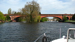
Guards Club Island, also known as Bucks Ait or bucks' eyot is an island in the River Thames connected by footbridge by to Maidenhead, Berkshire accommodating a pier adjoining the Sounding Arch part of the railway bridge which was built in 1838 to designs by Brunel. The thin small island is connected to Guards Club Park by a low cast-iron and wood footbridge which blocks the near channel (backwater) to boat navigation apart from kayaks. The island gets its alternative name from eel bucks [1] from which the footbridge was adapted in 1865 to allow access to its Guards Club Boathouse (since demolished).

Contents

The island is special status part of Guards Club Park (a public open space). Access to the island, a nesting site for water fowl, is restricted between December and June.

Related Research Articles

Teddington Lock

Teddington Lock is a complex of three locks and a weir on the River Thames between Ham and Teddington in the London Borough of Richmond upon Thames, England. It was first built in 1810.

Pipers Island

Pipers Island, or Piper's Island, is the third-smallest map-named island in the River Thames, in England. It is on the Reading, Berkshire reach. It is toward the edge of the central urban area of the town of Reading and connected by a gangway to Caversham Bridge, a road and pedestrian bridge that links that town to its left bank suburb of Caversham.

Cookham Lock

Cookham Lock is a lock with weirs situated on the River Thames near Cookham, Berkshire, about a half-mile downstream of Cookham Bridge. The lock is set in a lock cut which is one of four streams here and it is surrounded by woods. On one side is Sashes Island and on the other is Mill Island connected to Formosa Island, the largest on the non-tidal Thames.

Thames Path

The Thames Path is a National Trail following the River Thames from its source near Kemble in Gloucestershire to the Thames Barrier at Charlton, south east London. It is about 184 miles (296 km) long. A path was first proposed in 1948 but it only opened in 1996.

Wheatleys Ait

Wheatley's Ait or Wheatley Eyot is an ait (island) in the River Thames of approximately 8 hectares on the reach above Sunbury Lock, close to the northern side and in the post town Sunbury-on-Thames however in the Borough of Elmbridge in Surrey, England.

Rivermead Island

Rivermead Island is a flat grassy island in the River Thames on the reach above Molesey Lock at Sunbury-on-Thames, Surrey, England which is owned mostly by Spelthorne and as to a small part by Elmbridge Borough Council.

Bourne End Railway Bridge

Bourne End Railway Bridge is a railway bridge carrying the Marlow Branch Line, and a footpath over the River Thames in Bourne End, Buckinghamshire, England. It crosses the Thames on the reach between Cookham Lock and Marlow Lock.

Old Windsor Lock

Old Windsor Lock is a lock on the River Thames in England on the right bank beside Old Windsor, Berkshire. The lock marks the downstream end of the New Cut, a meander cutoff built in 1822 by the Thames Navigation Commissioners which created Ham Island. The lock and a wider footbridge give access to the island. Two weirs are associated; the smaller adjoins and the larger is upstream. The lock is the ninth lowest of the forty-five on the river.

Boveney Lock

Boveney Lock is a lock on the River Thames situated on the Buckinghamshire bank opposite the Windsor Racecourse and close to Eton Wick. Boveney is a village a little way upstream on the same side. The lock was first built in 1838 by the Thames Navigation Commission. The lock was rebuilt in 1898 closer to the Buckinghamshire bank, and a set of boat rollers were installed on the old site.

Temple Footbridge

Temple Footbridge is a pedestrian only bridge near Hurley, Berkshire across the River Thames in England. It connects the Buckinghamshire and Berkshire banks. It crosses the Thames just above Temple Lock.

Taggs Island

Tagg's Island, in the London Borough of Richmond upon Thames, is an island on the River Thames on the reach above Molesey Lock and just above Ash Island.

Sunbury Court Island

Sunbury Court Island is a long, pedestrianised residential island of houses and bungalows in the River Thames in England on the 'Sunbury and Hampton' or 'Molesey' reach, above Molesey Lock in Sunbury-on-Thames, Surrey, England.

Grand Junction Isle

Grand Junction Isle is a small island in the River Thames on the reach above Molesey Lock at Sunbury-on-Thames, Surrey, England. It is just downstream of Sunbury Court Island, which is three times longer and also close to the north bank.

Sunbury Lock Ait

Sunbury Lock Ait is the ait (island) in the River Thames in England adjacent to Sunbury Lock between Walton-on-Thames, and Sunbury-on-Thames, Surrey. It is unpopulated, but accessible by a footbridge over the lock cut from a wide section of the Thames Path towpath on the southern bank as well as walkways on the lock gates. Thirdly, a walkway links to Wheatley's Ait upstream, across the weir, but this is closed to the public. The quite long, thin island is inaccessible from Sunbury-on-Thames where it faces a long section of public riverbank, a few private conservation area Victorian terraces with moorings and two pubs also with moorings.

Hollyhock Island

Hollyhock Island is an inhabited island in the River Thames in England on the reach between Bell Weir Lock and Penton Hook Lock.

Bridge Eyot

Bridge Eyot also known as Bridge Ait is an island in the River Thames in England just above Maidenhead Bridge on the reach above Bray Lock, near Maidenhead, Berkshire. The island is owned by the Royal Borough of Windsor and Maidenhead.

Isleworth Ait

Isleworth Ait, also known as Isleworth Eyot, is a between 3.5-hectare (8.6-acre) and 9.370-acre (3.792 ha) teardrop-shaped island in the River Thames in England. The long ait is on the Tideway facing Old Isleworth and the towpath alongside the Royal Mid-Surrey Golf Club. These places are in the London Boroughs of Hounslow and Richmond upon Thames. The island faces Heron's Place and a number of commercial buildings.

Corporation Island

Corporation Island is a small island on the River Thames in London. The island is between Richmond Bridge and Richmond Railway Bridge, where it forms part of the celebrated view from the Richmond waterfront. Its name seems to derive from its owners, the Corporation of Richmond, now the London Borough of Richmond upon Thames. It is uninhabited and heavily wooded, and was formerly known as Richmond Ait.

Gibraltar Islands

Gibraltar Islands are a pair of islands in the River Thames in England above Bourne End Railway Bridge on the reach above Cookham Lock, near Cookham Dean, Berkshire.

Benns Island

Benn's Island, previously named Church Eyot, Kember’s Eyot and sometimes referred to as Benn's Ait, is a private 0.1-acre (0.040 ha) ait (island) on the River Thames south-west of London. It is among a string of narrow islands above Molesey Lock and due to its clubhouse and size — the second-smallest named island on the Thames — it has deep foundation pilings to raise the building more than 1 m above the water line.

References

  1. Cove-Smith, Chris (2006). The River Thames Book. Imray Laurie Norie and Wilson. ISBN   0-85288-892-9.

See also

Next island upstream River Thames Next island downstream
Bridge Eyot Guards Club Island Headpile Eyot

Coordinates: 51°31′18″N0°42′07″W / 51.5217°N 0.7020°W / 51.5217; -0.7020