
Andhra Pradesh is a state in the southern coastal region of India. It is the seventh-largest state with an area of 162,970 km2 (62,920 sq mi) and the tenth-most populous state with 49,577,103 inhabitants. It shares borders with Chhattisgarh, Odisha, Karnataka, Tamil Nadu, Telangana and the Bay of Bengal. It has the second-longest coastline in India at about 974 km (605 mi). After existence as Andhra State and unified Andhra Pradesh, the state took its present form on 2 June 2014, when the new state of Telangana was formed through bifurcation. Amaravati is the capital of the state, with the largest city being Visakhapatnam. Water sharing disputes and asset division with Telangana are not yet resolved. Telugu, one of the classical languages of India used by the majority of people, is the first official language.

Chittoor is a city and district headquarters in Chittoor district of the Indian state of Andhra Pradesh. It is also the mandal and divisional headquarters of Chittoor mandal and Chittoor revenue division respectively. The city has a population of 153,756 and that of the agglomeration is 175,647.

Coastal Andhra or Kosta Andhra is a geographic region in the Indian state of Andhra Pradesh. Vijayawada is the largest city in this region. Region share borders with Uttarandhra, Rayalaseema and Telangana. It was part of Madras State before 1953 and Andhra State from 1953 to 1956. According to the 2011 census, it has an area of 91,915 square kilometres (35,489 sq mi) which is 57.99% of the total state area and a population of 34,193,868 which is 69.20% of Andhra Pradesh state population. This area includes the coastal districts of Andhra Pradesh on the Circar Coast between the Eastern Ghats and the Bay of Bengal, from the northern border with Odisha to Rayalaseema in the south.

Chandragiri is a suburb and neighbourhood of Tirupati and located in Tirupati district of the Indian state of Andhra Pradesh. It is a part of Tirupati urban agglomeration and a major growing residential area in Tirupati It is the mandal headquarters of Chandragiri mandal in Tirupati revenue division. It also falls in the jurisdictional limit of Tirupati Urban Development Authority. Chandragiri is the southwestern entrance of Tirupati for vehicles coming from Bangalore, Kerala and Tamil Nadu. Kalyana Venkateswara Temple, Srinivasamangapuram is located next to Chandragiri through which well-laid stone footpaths called Srivari Mettu are available to reach Tirumala on foot
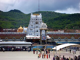
Tirupati is a city in the Indian state of Andhra Pradesh. It is the administrative headquarters of the Tirupati district. The city is home to the important Hindu shrine of Tirumala Venkateshwara Temple and other historic temples. It is located at a distance of 150 km from Chennai, 250 km from Bangalore, 406 km from Amaravati. It is one of the eight Svayam vyakta kshetras dedicated to Vishnu. Tirupati is a municipal corporation and the headquarters of Tirupati (urban) mandal, Tirupati (rural) mandal, and the Tirupati revenue division.

Sri Venkateswara National Park is a national park and biosphere reserve in Tirupati in Andhra Pradesh, India. The total area of the park is 353 km2. The park is known for its many waterfalls, including the Talakona, Gundalakona and Gunjana. As the Government of India declared the Seshachalam Hills as one of the biosphere reserves of India in 2010, this national park becomes the part of it.

Chittoor district is one of the eight districts in the Rayalaseema region of the Indian state of Andhra Pradesh. It had a population of 18,72,951 at the 2011 census of India. It is a major market centre for mangoes, grains, sugarcane, and peanuts. The district headquarters is at Chittoor City.

The Borra Caves(Borrā Guhalu) are located on the East Coast of India, in the Ananthagiri hills of the Araku Valley of the Alluri Sitharama Raju district in Andhra Pradesh. The caves, one of the largest in the country, at an elevation of about 705 m (2,313 ft), distinctly exhibit a variety of speleothems ranging in size and irregularly shaped stalactites and stalagmites. The caves are basically karstic limestone structures extending to a depth of 80 m (260 ft), and are considered the deepest caves in India. The native name for the caves is Borrā Guhalu where Borra means abdomen in and Guhalu means caves in Telugu language.
Narayanavanam is a census town in Tirupati district of the Indian state of Andhra Pradesh. It is the headquarters of Narayanavanam mandal in Sri Kalahasti revenue division. The town is known for Kalyana Venkateswara Temple dedicated to Lord Venkateswara and constructed in 1541 AD.

Srikalahasti is a town in Tirupati district located in the Indian state of Andhra Pradesh. It is a municipality and the revenue division of Srikalahasti mandal and Srikalahasti revenue division. It is a part of the Tirupati Urban Development Authority, which is located on the banks of the River Swarnamukhi.

Pakala is a town in Tirupati district of the Indian state of Andhra Pradesh. It is the mandal headquarters of Pakala mandal. It comes under Tirupati revenue division.

Nagalapuram is a Mandal Headquarter in Tirupati district of the Indian state of Andhra Pradesh. It is the mandal headquarters of Nagalapuram mandal in Srikalahasti revenue division. This town is home to Vedanarayana Temple, where the presiding deity Vishnu is in the form of Matsya, the first incarnation of Dasavatara.
Pichatur is a village in Tirupati district of the Indian state of Andhra Pradesh. It is the mandal headquarters of Pitchatur mandal.

Yerpedu is a place situated in Tirupati district of the Indian state of Andhra Pradesh. It is a part of Tirupati suburb and is located near Sri Kalahasti. It falls in the jurisdictional limit of Tirupati Urban Development Authority. It is the mandal headquarters of Yerpedu mandal.

Andhra Pradesh is a state in India. Andhra Pradesh Tourism Development Corporation (APTDC) is a state government agency which promotes tourism in Andhra Pradesh, describing the state as the Koh-i-Noor of India. Andhra Pradesh has a variety of tourist attractions including beaches, hills, caves, wildlife, forests and temples.

The Gudimallam Lingam is an ancient linga in the Parasurameswara Swamy Temple of Gudimallam, a small village near Tirupati city in the Yerpedu mandal of the Tirupati district of Andhra Pradesh, India. It is situated about 13 kilometers south-east of Tirupati city.
Talakona is situated in Tirupati district of Andhra Pradesh, India. It is a resort with waterfalls, dense forests and wildlife. Talakona waterfall is in Sri Venkateswara National Park, Tirupati district of Andhra Pradesh. With a 270 feet (82 m)-fall, Talakona is the highest waterfall in Andhra Pradesh state. Talakona is also known for the Lord Siddheswara Swamy Temple, which is located close to the waterfall.
Jaladheeswara Swamy Temple, popularly known as Sree Balaparvati Sametha Jaladheeswara Aalayam, is in a village named Ghantasala in Krishna District, Andhra Pradesh, India.
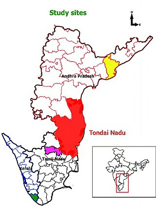
Tondaimandalam, also known as Tondai Nadu, is a historical region located in the northernmost part of Tamil Nadu and southernmost part of Andhra Pradesh. The region comprises the districts which formed a part of the legendary kingdom of Athondai Chakravarti. The boundaries of Tondaimandalam are ambiguous – between the river basins of Penna River and Ponnaiyar River. During the reign of Rajaraja I, this region was called as Jayankonda Cholamandalam.
Tirupati district is one of the eight districts of Rayalaseema region in the Indian state of Andhra Pradesh. The district headquarters is located at Tirupati city. This district is known for its numerous historic temples, including the Hindu shrine of Tirumala Venkateswara Temple and Sri Kalahasteeswara temple. The district is also home to Satish Dhawan Space Centre, a rocket launch centre located in Sriharikota. The river Swarnamukhi flows through Tirupati, Srikalahasti, Naidupeta, Vakadu and join into the Bay of Bengal.


