
The Barbary macaque, also known as Barbary ape or magot, is a macaque species native to the Atlas Mountains of Algeria and Morocco along with a small introduced population in Gibraltar. It is one of the best-known Old World monkey species.

The Bejaia province, stylized Béjaïa in French, is a province of Algeria in the Kabylie region. The province's capital city is Béjaïa, the terminus of the Béni Mansour-Bejaïa line.

Petite Kabylie or Petite Kabylia is a natural region in the mountainous area of northern Algeria. The Petite Kabylie is part of the greater Kabylie region.

Blida is a province (wilaya) in Algeria. Its capital is Blida. The Chréa National Park is situated here.

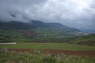
The Middle Atlas is a mountain range in Morocco. It is part of the Atlas mountain range, a mountainous region with more than 100,000 km2, 15 percent of its landmass, rising above 2,000 metres. The Middle Atlas is the northernmost and second highest of three main Atlas Mountains chains of Morocco. To south, separated by the Moulouya and Um Er-Rbiâ rivers, lies the High Atlas. The Middle Atlas form the westernmost end of a large plateaued basin extending eastward into Algeria, also bounded by the Tell Atlas to the north and the Saharan Atlas to the south, both lying largely in Algeria. North of the Middle Atlas and separated by the Sebou River, lie the Rif mountains which are an extension of the Baetic System, which includes the Sierra Nevada in the south of Spain. The basin of the Sebou is not only the primary transportation route between Atlantic Morocco and Mediterranean Morocco but is an area, watered by the Middle Atlas range, that constitutes the principal agricultural region of the country.
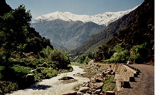
Ourika River is a river in Morocco, at 31.4°N 7.783333°W. It rises in the High Atlas and flows through the Ourika Valley, 30 km from Marrakech.
The national park of Djurdjura is one of the national parks of Algeria. It is located in Kabylie and is named after the Djurdjura Range of the Tell Atlas.

The Taza National Park is one of the smaller national parks of Algeria. It is located in Jijel Province in the region of the Tell Atlas, and is named after the nearby city of Taza. Its total area is 3,807 hectares and it includes parts of the forested area of the Guerrouch massif. The lower parts of the park seldom experience frost and are relatively warm and dry, while the peaks may have a covering of snow in winter. The annual precipitation in the park ranges from 1,000 to 1,400 millimetres and the annual mean temperature is around 18 °C (64 °F).

The Chréa National Park(Arabic:الحديقة الوطنية الشريعة) is one of the largest national parks of Algeria. It is located in Blida Province, named after Chréa, a town near this park. The park, located in a mountainous area known as the Blidean Atlas includes the ski station of Chréa, one of the few ski stations in Africa where skiing can be done on natural snow, and the grotto of Chiffa.

Mediterranean conifer and mixed forests is an ecoregion, in the temperate coniferous forest biome, which occupies the high mountain ranges of North Africa. The term is also a botanically recognized plant association in the African and Mediterranean literature.

Akfadou is a town in northern Algeria in the Béjaïa Province. Alternatively the town and its local area are known as Agfadou. This locale is noted for its local population of Barbary macaques, Macaca sylvanus. Notable features in the area include Gouraya National Park.
Ifrane National Park is a national park located in the Middle Atlas mountain range, in Morocco. Its territory extends over the Western part of the Middle Atlas mountains and areas within the provinces of Ifrane and Boulmane. It was established in 2004,and covers an area of 125.000 ha. Much of the park is forested with Atlas cedar. Ifrane National Park is one of the few remaining habitats for the Barbary macaque, Macaca sylvanus; this primate prehistorically had a much broader range in North Africa, but currently survives as an endangered species in narrowly restricted and fragmented habitats.
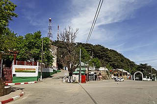
Chrea is a town in Algeria, located in Blida Province, Ouled Yaïch District, in a mountainous area named Tell Atlas, near Blida.
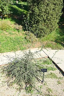
Fraxinus dimorpha is a species of ash tree native to Morocco and Algeria in Northern Africa. An example occurrence of F. dimorpha is the Ourika River Valley, which is also the sole location within the High Atlas Range where the endangered primate Barbary macaque, Macaca sylvanus is known to occur, is the southernmost species of the genus in the world.

Chiffa is a town and gorge in the Tell Atlas Mountains of northern Algeria. This gorge is one of the few habitat areas in Algeria that supports a sub-population of the Barbary macaque, Macaca sylvanus.
The Djebel Babor Nature Reserve is a protected area in Algeria. The reserve is within the Babor Mountains. Much of this area is forested with Mediterranean conifer and mixed forests. This reserve offers one of the few remaining disjunctive habitats for the endangered Barbary macaque, Macaca sylvanus, a primate species which prehistorically held a much wider range. The reserve is also a significant birdwatching area.
The Babor Range is a mountain range of the Tell Atlas in Algeria. The highest point of the range is 2,004 m high Mount Babor.

Pic des Singes is a peak in northern Algeria, northwest of the town of Béjaïa. It is located in the Cap Carbon area of the Tell Atlas range, on the Mediterranean coast.
The Tizguit Valley is a river-cut landform in the Middle Atlas mountain range, in the Fès-Meknès region of Morocco.
The Inaouen River is a watercourse in Morocco. It is tributary of the Sebou River. The river rises in the Middle Atlas mountain range. A major dam, the Idriss I, was constructed on the Inaouen River in 1973.

