
Sandwich is a town and civil parish in the Dover District of Kent, south-east England. It lies on the River Stour and has a population of 4,985. Sandwich was one of the Cinque Ports and still has many original medieval buildings, including several listed public houses and gates in the old town walls, churches, almshouses and the White Mill. While once a major port, it is now 2 miles (3 km) from the sea due to the disappearance of the Wantsum Channel. Its historic centre has been preserved. Sandwich Bay is home to nature reserves and two world-class golf courses, Royal St George's and Prince's. The town is also home to many educational and cultural events. Sandwich also gave its name to the food by way of John Montagu, 4th Earl of Sandwich, and the word sandwich is now found in several languages.
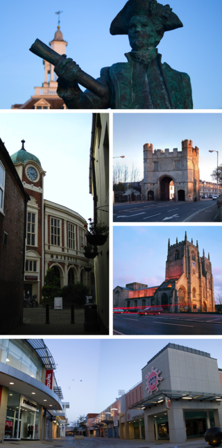
King's Lynn, known until 1537 as Bishop's Lynn and colloquially as Lynn, is a port and market town in the borough of King's Lynn and West Norfolk in the county of Norfolk, England. It is 36 miles (58 km) north-east of Peterborough, 44 miles (71 km) north-north-east of Cambridge and 44 miles (71 km) west of Norwich.

Barnstaple is a river-port town and civil parish in the North Devon district of Devon, England. The town lies at the River Taw's lowest crossing point before the Bristol Channel. From the 14th century, it was licensed to export wool from which it earned great wealth. Later it imported Irish wool, but its harbour silted up and other trades developed such as shipbuilding, foundries and sawmills. A Victorian market building survives, with a high glass and timber roof on iron columns.

Guildhall is a municipal building in the Moorgate area of the City of London, England. It is off Gresham and Basinghall streets, in the wards of Bassishaw and Cheap. The current building dates from the 15th century; however documentary evidence suggests that a guildhall had existed at the site since at least the early 12th century. The building has been used as a town hall for several hundred years, and is still the ceremonial and administrative centre of the City of London and its Corporation. It should not be confused with London's City Hall, the administrative centre for Greater London. The term "Guildhall" refers both to the whole building and to its main room, which is a medieval great hall. It is a Grade I-listed building.
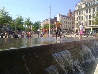
The Old Market Square is an open, pedestrianised city square in Nottingham, England, forming the heart of the city, and covering an area of approximately 12,000 square metres (130,000 sq ft), or about 3 acres (1.2 ha). It is one of the largest paved squares in the United Kingdom.

Corporation Street is a main shopping street in Birmingham city centre, England. Though it has a distinct southern terminus – the junction of New Street and Stephenson Place, adjacent to the entrance of New Street station – the location of its northern terminus is debatable.

The Lion Yard shopping centre is a covered shopping centre in the city centre of Cambridge, England. Construction work on the centre, which is bounded by St Andrew's Street, Corn Exchange Street, and Petty Cury, commenced in 1970 and the development contained a library, multi-storey car park and magistrates' court.

Corn Exchange Street is a street in central Cambridge, England. It runs between Wheeler Street to the northwest and Downing Street to the southeast. To the northeast, Guildhall Place, a cul-de-sac, runs parallel with Corn Exchange Street at the northern end, an extension of Guildhall Street.
Wheeler Street is a street in central Cambridge, England. It runs between Bene't Street to the southwest and Guildhall Street and Corn Exchange Street to the northeast. To the east, Guildhall Place, a cul-de-sac, runs southeast from the junction with Guildhall Street, parallel with Corn Exchange Street at its northwestern end, as an extension of Guildhall Street.

Market Hill is the location of the marketplace in central Cambridge, England. Operating as a marketplace since Saxon times, a daily outdoor market with stalls continues to run there.

Market Street is a shopping street in central Cambridge, England. It runs between Market Hill, location of the city's central Market Square to the west and Sidney Street to the east. On the other side of the market square, the street continues west as St Mary's Street, north of Great St Mary's, the University church. On the other side of Sidney Street is Hobson's Passage leading east to Hobson Street. To the north is Market Passage and to the south is Petty Cury, a pedestrianised shopping street.

Petty Cury is a pedestrianised shopping street in central Cambridge, England. It connects Market Hill, the location of Cambridge's central outdoor market, and Guildhall Street to the west with the shopping streets of Sidney Street and St Andrew's Street to the east. Hobson Street leads off north on the opposite side of the street at the eastern end, on the corner of Christ's College, one of the historic University of Cambridge colleges.

Cambridge Guildhall is a civic building in the centre of the historic city of Cambridge, England. It includes two halls, The Large Hall and The Small Hall, and is used for many disparate events such as comedy acts, conferences, craft fairs, live music, talks, and weddings. It is also used by the University of Cambridge for certain examinations. It is owned and managed by the Cambridge City Council, and it is their seat of government. The Guildhall is located on the south side of Market Hill, the market square in Cambridge, between Peas Hill to the west and Guildhall Street to the east. It is a Grade II listed building.

Norwich Market is an outdoor market consisting of around 200 stalls in central Norwich, England. Founded in the latter part of the 11th century to supply Norman merchants and settlers moving to the area following the Norman conquest of England, it replaced an earlier market a short distance away. It has been in operation on the present site for over 900 years.
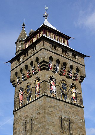
Castle Quarter is an independent retail destination area in the north of the city centre of Cardiff, Wales. Castle is also a community (parish) of Cardiff.
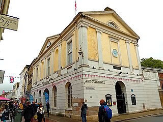
The Guildhall in Barnstaple in Devon in the United Kingdom is the Guildhall for the town and was completed in 1828, replacing an earlier Guildhall. Beneath and behind the Guildhall is the Pannier Market; completed in 1855, the building has been a Grade II* listed building since 19 January 1951.

Coney Street is a major shopping street in the city centre of York, in England. The street runs north-west from the junction of Spurriergate and Market Street, to St Helen's Square. New Street leads off the north-east side of the street, as does a snickelway leading to the Judges Court hotel, while several snickelways lead from the south-west side down to the River Ouse, including Blanshard's Lane, and paths leading to City Screen.

Peasholme Green is a street on the eastern edge of the city centre of York, in England.

Chester Street is a street in Wrexham city centre, North Wales. It was once a main north–south road on the edge of the centre of Wrexham. The street has several listed buildings, as well as Wrexham's civic centre containing various council, memorial and leisure buildings, Coleg Cambria's Yale campus, Tŷ Pawb and various historical buildings now demolished.
