
The Bull Ring is a major shopping area in central Birmingham England, and has been an important feature of Birmingham since the Middle Ages, when its market was first held. Two shopping centres have been built in the area; in the 1960s, and then in 2003; the latter is styled as one word, Bullring. When combined with Grand Central it is the United Kingdom's largest city centre based shopping centre.

Commercial Street is an arterial road in Tower Hamlets, east London that runs north to south from Shoreditch High Street to Whitechapel High Street through the East End district of Spitalfields. The road is a section of the A1202 London Inner Ring Road and as such forms part of the boundary of the London congestion charge zone.
Leadenhall Street is a street in the City of London. It is about 1⁄3-mile-long (0.54 km) and links Cornhill in the west to Aldgate in the east. It was formerly the start of the A11 road from London to Norwich, but that route now starts further east at Aldgate.

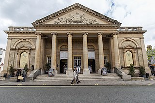
Cambridge Corn Exchange is a concert venue located in Cambridge, England with a capacity up to 1,681 people.

All Hallows, Honey Lane was a parish church in the City of London, England. Of medieval origin, it was destroyed in the Great Fire of London in 1666 and not rebuilt; the site became part of Honey Lane Market, which was in turn partially cleared to make way for the City of London School in the 19th century. Much of the area was destroyed during the bombing in World War II and has been redeveloped. The name Honey Lane is retained in a nearby walkway.

The Lion Yard shopping centre is a covered shopping centre in the city centre of Cambridge, England. Construction work on the centre, which is bounded by St Andrew's Street, Corn Exchange Street, and Petty Cury, commenced in 1970 and the development contained a library, multi-storey car park and magistrates' court.

Downing Street is a street in central Cambridge, England. It runs between Pembroke Street and Tennis Court Road at the western end and a T-junction with St Andrew's Street at the eastern end. Corn Exchange Street and St Tibbs Row lead off to the north. Downing Place leads off to the south.
Sidney Street is a major street in central Cambridge, England. It runs between Bridge Street at the junction with Jesus Lane to the northwest and St Andrew's Street at the junction with Hobson Street to the southeast.
Wheeler Street is a street in central Cambridge, England. It runs between Bene't Street to the southwest and Guildhall Street and Corn Exchange Street to the northeast. To the east, Guildhall Place, a cul-de-sac, runs southeast from the junction with Guildhall Street, parallel with Corn Exchange Street at its northwestern end, as an extension of Guildhall Street.
Bridge Street is a historic street in the north of central Cambridge, England. It runs between Magdalene Street at the junction with Thompson's Lane to the northwest and Sidney Street at the junction with Jesus Lane to the southeast. Bridge Street used to continue over the Great Bridge on the River Cam, hence the name, but this part is now known as Magdalene Street after Magdalene College, which fronts onto the street.
Peas Hill is a street in central Cambridge, England. It runs between Wheeler Street to the south and Market Hill to the north. King's Parade runs parallel with the street to the west. Guildhall Street runs parallel to the east.

Market Hill is the location of the marketplace in central Cambridge, England. Operating as a marketplace since Saxon times, a daily outdoor market with stalls continues to run there.
Petty Cury is a pedestrianised shopping street in central Cambridge, England. It connects Market Hill, the location of Cambridge's central outdoor market, and Guildhall Street to the west with the shopping streets of Sidney Street and St Andrew's Street to the east. Hobson Street leads off north on the opposite side of the street at the eastern end, on the corner of Christ's College, one of the historic University of Cambridge colleges.
Guildhall Street is a street in central Cambridge, England. To the north is the southeast corner of Market Hill at the junction with the pedestrianised shopping street Petty Cury. To the south it continues as Guildhall Place, a cul-de-sac, at the junction with Wheeler Street, close to the northern end of Corn Exchange Street.

Mark Lane is a street in the City of London linking Great Tower Street and Fenchurch Street. It gave its name to the nearby Mark Lane tube station, which was opened in 1884, renamed Tower Hill in 1964, and closed three years later. For some 240 years, Mark Lane was known for the Corn Exchange ; it occupied a series of properties on the east side of the southern end of the street.

Market Square is an open air urban space in Warwick, Warwickshire, England. It has for many centuries been the centre of the town taking on a number of functions during its history.

Bellamy and Hardy was an architectural practice in Lincoln, England, that specialised particularly in the design of public buildings and non-conformist chapels. Pearson Bellamy had established his own architectural practice by 1845 and he entered into a partnership with James Spence Hardy in June 1853. Both partners had previously worked for the Lincoln architect William Adams Nicholson. Hardy was described as "Chief Clerk" to Nicholson. Hardy joined Pearson Bellamy immediately after the sudden death of Nicholson. As all known architectural drawings by the practice are signed Pearson Bellamy, it is likely that Bellamy was the architect and Hardy was the administrator in the practice. The partnership lasted until 1887 After this Bellamy continued to practice until 1896.
Corn exchanges in England are distinct buildings which were originally created as a venue for corn merchants to meet and arrange pricing with farmers for the sale of wheat, barley, and other corn crops. The word "corn" in British English denotes all cereal grains, such as wheat and barley. With the repeal of the Corn Laws in 1846, a large number of corn exchanges were built, particularly in the corn-growing areas of Eastern England. However, with the fall in price of English corn as a result of cheap imports, corn exchanges mostly ceased to be built after the 1870s. Increasingly they were put to other uses, particularly as meeting and concert halls. Many found a new lease of life in the early 20th century as cinemas. Following the Second World War, many could not be maintained, and they were demolished. In the 1970s their architectural importance came to be appreciated, and most of the surviving examples are listed buildings. Most of the surviving corn exchanges have now been restored, and many have become arts centres, theatres, or concert halls.

Ousegate is a street in the city centre of York, in England. It is divided into High Ousegate and Low Ousegate.

