
Guildhall is a municipal building in the Moorgate area of the City of London, England. It is off Gresham and Basinghall streets, in the wards of Bassishaw and Cheap. The current building dates from the 15th century; however documentary evidence suggests that a guildhall had existed at the site since at least the early 12th century. The building has been used as a town hall for several hundred years, and is still the ceremonial and administrative centre of the City of London and its Corporation. It should not be confused with London's City Hall, the administrative centre for Greater London. The term "Guildhall" refers both to the whole building and to its main room, which is a medieval great hall. It is a Grade I-listed building.
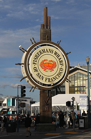
Fisherman's Wharf is a neighborhood and popular tourist attraction in San Francisco, California, United States. It roughly encompasses the northern waterfront area of San Francisco from Ghirardelli Square or Van Ness Avenue east to Pier 35 or Kearny Street. The F Market streetcar runs through the area, the Powell / Hyde cable car line runs to Aquatic Park, at the edge of Fisherman's Wharf, and the Powell / Mason cable car line runs a few blocks away.

The Corn Exchange is an events and concert venue located on Wheeler Street in Cambridge, Cambridgeshire, England. The structure, which was commissioned as a corn exchange, is a Grade II listed building.

The Lion Yard shopping centre is a covered shopping centre in the city centre of Cambridge, England. Construction work on the centre, which is bounded by St Andrew's Street, Corn Exchange Street, and Petty Cury, commenced in 1970 and the development contained a library, multi-storey car park and magistrates' court.

Pembroke Street is a street in central Cambridge, England. It runs between Downing Street and Tennis Court Road at the eastern end and a junction with Trumpington Street at the western end. It continues west on the other side of Trumpington Street as Mill Lane.

Downing Street is a street in central Cambridge, England. It runs between Pembroke Street and Tennis Court Road at the western end and a T-junction with St Andrew's Street at the eastern end. Corn Exchange Street and St Tibbs Row lead off to the north. Downing Place leads off to the south.

Northampton Street is a street in the north of central Cambridge, England. It runs between Madingley Road and Queen's Road to the west and Castle Street, by Castle Hill, Chesterton Lane, and Magdalene Street to the east.

Corn Exchange Street is a street in central Cambridge, England. It runs between Wheeler Street to the northwest and Downing Street to the southeast. To the northeast, Guildhall Place, a cul-de-sac, runs parallel with Corn Exchange Street at the northern end, an extension of Guildhall Street.

Tennis Court Road is a historic street in central Cambridge, England. It runs parallel with Trumpington Street to the west and Regent Street to the east. At the northern end is a junction with Pembroke Street to the west and Downing Street to the east. To the south as a T-junction with Lensfield Road. Fitzwilliam Street leads off the road to the west towards the Fitzwilliam Museum.
Peas Hill is a street in central Cambridge, England. It runs between Wheeler Street to the south and Market Hill to the north. King's Parade runs parallel with the street to the west. Guildhall Street runs parallel to the east.

Market Hill is the location of the marketplace in central Cambridge, England. Operating as a marketplace since Saxon times, a daily outdoor market with stalls continues to run there.

Petty Cury is a pedestrianised shopping street in central Cambridge, England. It connects Market Hill, the location of Cambridge's central outdoor market, and Guildhall Street to the west with the shopping streets of Sidney Street and St Andrew's Street to the east. Hobson Street leads off north on the opposite side of the street at the eastern end, on the corner of Christ's College, one of the historic University of Cambridge colleges.

Guildhall Street is a street in central Cambridge, England. To the north is the southeast corner of Market Hill at the junction with the pedestrianised shopping street Petty Cury. To the south it continues as Guildhall Place, a cul-de-sac, at the junction with Wheeler Street, close to the northern end of Corn Exchange Street.

Cambridge Guildhall is a civic building in the centre of the historic city of Cambridge, England. It includes two halls, The Large Hall and The Small Hall, and is used for many disparate events such as comedy acts, conferences, craft fairs, live music, talks, and weddings. It is also used by the University of Cambridge for certain examinations. It is owned and managed by the Cambridge City Council, and it is their seat of government. The Guildhall is located on the south side of Market Hill, the market square in Cambridge, between Peas Hill to the west and Guildhall Street to the east. It is a Grade II listed building.

The Old Addenbrooke's Site is a site owned by the University of Cambridge in the south of central Cambridge, England. It is located on the block formed by Fitzwilliam Street to the north, Tennis Court Road to the east, Lensfield Road to the south, and Trumpington Street to the west.
Austin Friary was a priory in Cambridge, Cambridgeshire, England. The priory was located at Peas Hill in central Cambridge from around 1289 until dissolution in 1538.
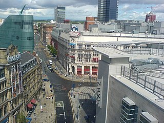
Corporation Street is a major thoroughfare in Manchester city centre, England. It runs from Dantzic Street to the junction of Cross Street and Market Street. Major buildings located on or adjacent to the street include the Arndale Centre, Exchange Square, The Printworks, Urbis and New Century House next to the CIS Tower.

Stonegate is a street in the city centre of York, in England, one of the streets most visited by tourists. Most of the buildings along the street are listed, meaning they are of national importance due to their architecture or history.

Lincoln City Centre is the historical and cultural area of Lincoln in Lincolnshire, England. It is defined as the areas along the city's High Street. Each part of the centre brings a differing main sector or sectors to the city with a small overlap between each area.
