
Southwark is a district of Central London situated on the south bank of the River Thames, forming the north-western part of the wider modern London Borough of Southwark. The district, which is the oldest part of South London, developed due to its position at the southern end of the early versions of London Bridge, for centuries the only dry crossing on the river. Around 43 AD, engineers of the Roman Empire found the geographic features of the south bank here suitable for the placement and construction of the first bridge.

John Fisher was an English Catholic bishop, theologian and Chancellor of the University of Cambridge. He is honoured as a martyr and saint by the Catholic Church.
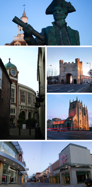
King's Lynn, known until 1537 as Bishop's Lynn and colloquially as Lynn, is a port and market town in the borough of King's Lynn and West Norfolk in the county of Norfolk, England. It is 36 miles (58 km) north-east of Peterborough, 44 miles (71 km) north-north-east of Cambridge and 44 miles (71 km) west of Norwich.
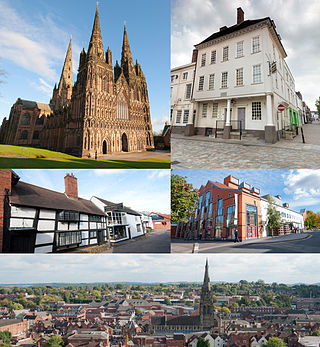
Lichfield is a cathedral city and civil parish in Staffordshire, England. Lichfield is situated 18 miles (29 km) south-east of the county town of Stafford, 9 miles (14 km) north-east of Walsall, 8 miles (13 km) north-west of Tamworth and 13 miles (21 km) south-west of Burton upon Trent. At the time of the 2021 Census, the population was 34,738 and the population of the wider Lichfield District was 106,400.
George Dance the Younger RA was an English architect and surveyor as well as a portraitist.

John Day was an English Protestant printer. He specialised in printing and distributing Protestant literature and pamphlets, and produced many small-format religious books, such as ABCs, sermons, and translations of psalms. He found fame, however, as the publisher of John Foxe's Actes and Monuments, also known as the Book of Martyrs, the largest and most technologically accomplished book printed in sixteenth-century England.

St Margaret, New Fish Street, was a parish church in the City of London.
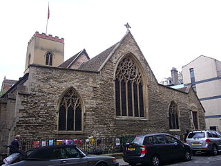
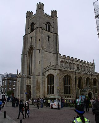
St Edward King and Martyr is a church located on Peas Hill in central Cambridge, England. It is dedicated to Edward the Martyr, who was King of England from 975 until his murder in 978. In 1525 it was at St Edward's that what is said to have been perhaps the first "openly evangelical" sermon of the English Reformation was delivered, and the church is sometimes labelled the "Cradle of the Reformation".

Corn Exchange Street is a street in central Cambridge, England. It runs between Wheeler Street to the northwest and Downing Street to the southeast. To the northeast, Guildhall Place, a cul-de-sac, runs parallel with Corn Exchange Street at the northern end, an extension of Guildhall Street.
St Mary's Street is a historic street in the centre of the University area in Cambridge, England. The street links with the junction of King's Parade and Trinity Street to the west, along which many of the University's oldest colleges are to be found. To the east is Market Hill, the location of the city's Market Square. The street continues as Market Street.
Wheeler Street is a street in central Cambridge, England. It runs between Bene't Street to the southwest and Guildhall Street and Corn Exchange Street to the northeast. To the east, Guildhall Place, a cul-de-sac, runs southeast from the junction with Guildhall Street, parallel with Corn Exchange Street at its northwestern end, as an extension of Guildhall Street.
Hills Road is an arterial road in southeast Cambridge, England. It runs between Regent Street at the junction with Lensfield Road and Gonville Place to the northwest and a roundabout by the Cambridge Biomedical Campus, continuing as Babraham Road to the southeast.

Market Hill is the location of the marketplace in central Cambridge, England. Operating as a marketplace since Saxon times, a daily outdoor market with stalls continues to run there.

Market Street is a shopping street in central Cambridge, England. It runs between Market Hill, location of the city's central Market Square to the west and Sidney Street to the east. On the other side of the market square, the street continues west as St Mary's Street, north of Great St Mary's, the University church. On the other side of Sidney Street is Hobson's Passage leading east to Hobson Street. To the north is Market Passage and to the south is Petty Cury, a pedestrianised shopping street.

Cambridge Guildhall is a civic building in the centre of the historic city of Cambridge, England. It includes two halls, The Large Hall and The Small Hall, and is used for many disparate events such as comedy acts, conferences, craft fairs, live music, talks, and weddings. It is also used by the University of Cambridge for certain examinations. It is owned and managed by the Cambridge City Council, and it is their seat of government. The Guildhall is located on the south side of Market Hill, the market square in Cambridge, between Peas Hill to the west and Guildhall Street to the east. It is a Grade II listed building.
Lensfield Road is a road in southeast central Cambridge, England. It runs between the junction of Trumpington Street and Trumpington Road to the west and the junction of Regent Street and Hills Road to the west. It continues as Gonville Place to the northeast past Parker's Piece, a large grassy area with footpaths.

Norwich Market is an outdoor market consisting of around 200 stalls in central Norwich, England. Founded in the latter part of the 11th century to supply Norman merchants and settlers moving to the area following the Norman conquest of England, it replaced an earlier market a short distance away. It has been in operation on the present site for over 900 years.

St Edward's Passage, known in the 18th century as Chain Lane, is a Y-shaped alleyway in Cambridge, England, between King's Parade—opposite the main gate of King's College—and Peas Hill. It houses the entrance and churchyard of the Church of St Edward King and Martyr; the Cambridge Arts Theatre; several cottages; G. David, an independent bookshop run from the same building since 1896; a few businesses; and student accommodation. It is a narrow, dark lane, with riven-stone paving, which opens out onto the much wider and sunnier King's Parade.
The following is a timeline of the history of London, the capital of England and the United Kingdom.

