Gwalior is a major city in the central Indian state of Madhya Pradesh; It is known as the City of Music having oldest musical gharana in existence. It lies in northern part of Madhya Pradesh and is one of the Counter-magnet cities. Located 313 kilometres (194 mi) south of New Delhi, the capital city of India and 446 kilometres (277 mi) from Bhopal, the state capital, Gwalior occupies a strategic location in the Gwalior Chambal region of India. The historic city and its fortress have been ruled by several historic Indian kingdoms. From the Alchon Huns in the 5th century AD to Gurjara Pratihara dynasty in the 8th century AD. It was passed on to Kachchhapaghatas in the 10th century AD. It fell into the hands of the Delhi Sultanate in 12th century AD, it was then passed on to the Tomars in the 13th century AD who were the vassal rulers of the Delhi Sultanate. The Mughal Empire conquered the city and its fortress in the 16th century AD. When the Mughal Empire was declining, it fell into the hands of Jat rulers, then to the Maratha in 1754, and lastly it was passed on to the Scindia Dynasty of Maratha Empire in early 18th century. In April 2021, It was found that Gwalior had the best air quality index amongst the 4 major cities in Madhya Pradesh.

Madhya Bharat, also known as Malwa Union, was an Indian state in west-central India, created on 28 May 1948 from twenty-five princely states which until 1947 had been part of the Central India Agency, with Jiwajirao Scindia as its Rajpramukh.

Nimar / Nimad is the southwestern region of Madhya Pradesh state in west-central India. This region has sub-regions which include Nimar, Khargone Khandwa Barwani Burhanpur and Dhar.

Morena, is a town and a district in the Indian state of northern Madhya Pradesh. The place gets its name from “mor” (peacock) and “raina”- which means a place where peacocks are found in abundance and is home to the largest number of peacocks in India.

The Bagh Caves are a group of nine rock-cut monuments, situated among the southern slopes of the Vindhya Range in Bagh town of Dhar district in Madhya Pradesh in central India. These monuments are located at a distance of 97 km from Dhar town. These are renowned for mural paintings by master painters of ancient India. The caves are examples of Indian rock-cut architecture, rather than naturally formed.
Ambah is a city and a municipality in Morena district in the state of Madhya Pradesh, India. It is the administrative headquarter of Ambah-Porsa Block. It was formerly known as Ambrish Nagari.Devendra Sakhwar (SC) of the Congress party is the present MLA from Ambah-Porsa Constituency.

Gwalior district is one of the 52 districts of Madhya Pradesh state in central India. The historic city of Gwalior is its administrative headquarters. Other cities and towns in this district are Antari, Bhitarwar, Bilaua, Dabra, Morar Cantonment, Pichhore, and Tekanpur. The district is at the centre of the Gird region.

Gwalior Division is an administrative subdivision of Madhya Pradesh state in central India. It includes the districts of Ashoknagar, Datia, Guna, Gwalior, and Shivpuri. The historic city of Gwalior is the administrative headquarters of the division.

Jhansi district is one of the districts of Uttar Pradesh state in northern India. The city of Jhansi is the district headquarters. The district is bordered on the north by Jalaun District, to the east by Hamirpur and Mahoba districts, to the south by Tikamgarh District of Madhya Pradesh state, to the southwest by Lalitpur District, which is joined to Jhansi District by a narrow corridor, and on the east by the Datia and Bhind districts of Madhya Pradesh. Population 19,98,603. Lalitpur District, which extends into the hill country to the south, was added to Jhansi District in 1891, and made a separate district again in 1974.
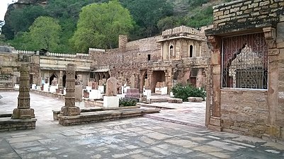
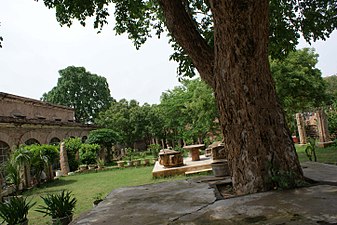
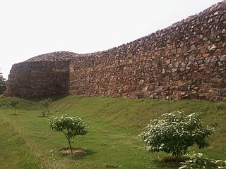
The Fort of Gwalior or the Gwalior Fort is a defence hill fort in Gwalior, India. Mughal Emperor Babur called it the "pearl amongst the fortresses of Hind" because of its impregnability and magnificence and it has also been nicknamed the Gibraltar of India. The history of the fort goes back to the 5th century or perhaps to a period still earlier. The old name of the hill as recorded in ancient Sanskrit inscriptions is Gopgiri. The current structure of the fort has existed at least since the 8th century, and the inscriptions and monuments found within what is now the fort campus indicate that it may have existed as early as the beginning of the 6th century, making it one of India's oldest defence fort still in existence. The modern-day fort, embodying a defensive structure and two palaces was built by the Tomar Rajput ruler Man Singh Tomar. It has witnessed the varying fortunes of the Guptas, the Hunas, the Pratiharas, the Kachhwahas, the Tomaras, the Pathans, the Surs, the Mughals, the English, the Jats, and the Marathas represented by the powerful Scindia dynasty who have left their landmarks in the various monuments which are still preserved.
Ambah is a city and a municipality in Morena district in the state of Madhya Pradesh, India. It is the administrative headquarter of Ambah-Porsa Block. It was formerly known as Ambrish Nagari.Devendra Sakhwar (SC) of the Congress party is the present MLA from Ambah-Porsa Constituency.

Man Singh Tomar was a Tomar ruler of Gwalior who ascended the throne in 1486 CE.
Anangpal II, popularly known as Anangpal Tomar, was an Indian ruler from the Tomara dynasty. He is known to have established and populated Delhi in the 11th century. He is often confused with Anangpal I, the founder of Tomar Dynasty of Delhi, who had reigned during the 8th century. He traced the lineage to Chandravanshi Kshatriya kings, namely Arjuna from the epic Mahabharata.

Datia Palace, also known as Bir Singh Palace or Bir Singh Dev Palace, is situated nearly 75 km from Gwalior city in Madhya Pradesh. The specialty of the palace is that it has 7 floors and no member of the royal family lived in the palace. The founder of the Datia State in Bundelkhand - Maharaj Birsingh Deo Build many such 52 monuments all around the country. Datia Palace is also known as Satkhanda Palace, Datia Mahal, and Purana Mahal or the "Old Palace". Historian Abdul Hamid Lahori came to this city with Shah Jahan on 19 November 1635. He said that the palace was nearly 80 meters long and was also this much broad. He said this as a very beautiful and strong palace.

Jahangir Mahal, Citadel of Jahangir, Orchha Palace, Mahal-e-Jahangir Orchha, Jahangir Citadel is a citadel and garrison located in Orchha, Madhya Pradesh, India.

The Orchha Fort complex, which houses a large number of ancient monuments consisting of the fort, palaces, temple, and other edifices, is located in the Orchha town in the Indian state of Madhya Pradesh. The fort and other structures within it were built by the Bundela Rajputs starting from the early 16th century by King Rudra Pratap Singh of the Orchha State and others who followed him.

Udaypur is a town in Vidisha district of the Indian state of Madhya Pradesh, near Vidisha city. It is the site of a well-preserved Śiva temple, a monument of national importance protected by the Archaeological Survey of India.
Sihoniya is a town in Morena district, in the Indian state of Madhya Pradesh. The town is sometimes referred to as Suhania; in medieval times it was called Siṃhapānīya. The settlement has a long history and a number of notable monuments, one being of national importance and protected by the Archaeological Survey of India.

Raja Mansingh Tomar Music & Arts University is a state university located at Gwalior, Madhya Pradesh, India. It was established in 2008 by the Government of Madhya Pradesh and is named after Maharaja Mansingh Tomar. The university offers courses in music, dance, fine arts and drama & theater. It has 170 affiliated colleges.