
The Maiden Tower is a 12th-century monument in the Old City, Baku, Azerbaijan. Along with the Shirvanshahs' Palace, dated to the 15th century, it forms a group of historic monuments listed in 2001 under the UNESCO World Heritage List of Historical Monuments as cultural property, Category III. It is one of Azerbaijan's most distinctive national emblems, and is thus featured on Azerbaijani currency notes and official letterheads.

Goranboy District is one of the 66 districts of Azerbaijan. It is located in the west of the country in the Ganja-Dashkasan Economic Region. The district borders the districts of Kalbajar, Tartar, Yevlakh, Samukh, and Goygol. Its capital and largest city is Goranboy. As of 2020, the district had a population of 105,000.

Julfa District is one of the 7 districts of the Nakhchivan Autonomous Republic of Azerbaijan. The district borders the districts of Ordubad, Babek, Shahbuz, as well as the Syunik Province of Armenia and the East Azerbaijan Province of Iran. Its capital and largest city is Julfa. As of 2020, the district had a population of 47,000.

Amaras Monastery is an Armenian monastery near the village of Sos, in the region of Nagorno-Karabakh, Azerbaijan. It was a prominent religious and educational center in medieval Armenia.

Gülüstan or Gulistan is a village in the Goranboy District of Azerbaijan. It is a part of the municipality of Buzluq.

Askeran is a town in the Khojaly District of Azerbaijan, in the region of Nagorno-Karabakh. Until 2023 it was controlled by the breakaway Republic of Artsakh, as the centre of its Askeran Province. The town had an ethnic Armenian-majority population until the exodus of the Armenian population of Nagorno-Karabakh following the 2023 Azerbaijani offensive in Nagorno-Karabakh. It is located on the left bank of the Karkar River (Qarqarçay), approximately 11 kilometres (7 mi) northeast of the regional capital, Stepanakert.
Qazançı, also known as Shahkert, is a village and municipality in the Julfa District of Nakhchivan, Azerbaijan.
Çalxanqala is a village and municipality in the Kangarli District of Nakhchivan, Azerbaijan. It is located 33 km in the north-west from the district center, on the south slope of the Daralayaz ridge. Its population is busy with grain-growing, vine-growing, beekeeping and animal husbandry. There are secondary school, music school, library, club and a medical center in the village. It has a population of 2,149. It was the last Armenian-populated town in Nakhchivan.
Gülüstan is a village and municipality in the Julfa District of Nakhchivan, Azerbaijan. It is located 5 km in the north-west from the district center, on the right bank of the Aras River.

Bana is a ruined early medieval cathedral in present-day Erzurum Province, eastern Turkey, in what had formerly been a historical marchland known to Armenians as Tayk and to Georgians as Tao.

Kotavank is a church located on a hill overlooking the Argitchi River and village of Nerkin Getashen, south of Lake Sevan in the Gegharkunik Province of Armenia. A large medieval cemetery surrounds the church with numerous khachkars. A modern cemetery adjacent has started to encroach upon the old one, leaving many of the khachkars and ancient tombstones upturned in a pile, moved from their original locations.
Operation Goranboy was a large-scale military offensive by Azerbaijan in the summer of 1992. Its aims were to take complete control of the entire territory of Nagorno-Karabakh and put a decisive end to the secessionist Nagorno-Karabakh Republic (NKR). This offensive is regarded as a successful breakthrough by the Azerbaijani Army and marked the peak of Azerbaijani success throughout the entire six years of the First Nagorno-Karabakh War.
The Battle of Aghdam took place on 23 July 1993 during the First Nagorno-Karabakh War, during which Armenian forces captured the Azerbaijani city of Aghdam. The city of Aghdam, which had about 50,000 inhabitants prior to its capture, is located about 30 km northeast of Stepanakert and 5 km east of the border of the former Nagorno-Karabakh Autonomous Oblast. Armenian forces considered Aghdam as a main staging area of Azerbaijani forces for attacks and artillery strikes against the Armenian-populated Nagorno-Karabakh region. A significant part of the surrounding Aghdam District was captured by Armenian forces as well.

Shahbulag Castle is an 18th-century fortress near Aghdam in Azerbaijan built by the Karabakh Khan Panah Ali.
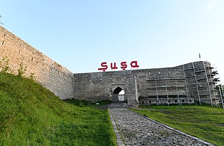
The Shusha fortress or Shushi fortress is a fortress surrounding the historical centre of Shusha, also called Shushi. The newly conquered castle town was called "Panahabad fortress" named after Panah Ali Khan who together with Melik Shahnazar was the founder of the fort. In later years, the city was just called "Fortress". A settlement at Shusha is first recorded in a 15th-century illustrated Armenian gospel which mentions the "Shushu village".
Handaberd, also known as Lekh Castle or Lev Castle, is a 9th-century fortress located in the Kalbajar District of Azerbaijan, near the villages of Lev and Knaravan, on the right bank of the Levçay River. It was built by Atrnerseh I, ruler of the Armenian Principality of Khachen, who resided there.

The Central Acropolis of the ancient Maya city of Tikal is an architectural complex located immediately to the south of the Great Plaza. Tikal is one of the most important archaeological sites of the pre-Columbian Maya civilization and is located in the Petén Department of northern Guatemala. The complex served dual administrative and residential purposes. The Central Acropolis was first established in the Late Preclassic period of Mesoamerican chronology, and it remained in use until approximately 950 AD.
Galeyi Beygurt, also known as Galey-Bughurt or simply Bughurt fortress is a historic monument located 20 km north-east of the center of Shamakhi city.

Chemberekend Cemetery was a multi-confessional cemetery in Baku used until July 1883. The cemetery was located in the southwestern part of the Baku fortress, to the east of the Chemberekend village, a suburb of Baku, on the northeastern slope of the hill known as Pirvanzara. On the city plan of Baku in 1899, drawn up by the city engineer Colonel Nikolai von der Nonne, the cemetery during this period consisted of three sections: the northern section for Muslim burials, the central section for Armenians and Gregorians, and the southern section for Orthodox burials. From the suburb of Chemberekend, the cemetery was separated by Nizhnyaya Chemberekend street. It was demolished under Soviet rule in the 1930s.

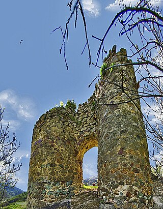
Gulustan Fortress or Castle is a medieval castle dating back to the 9th-12th centuries located in Shamakhi District of Azerbaijan. Although the oldest archeological findings from the castle date back to the 9th century, the Gulustan castle was radically rebuilt and strengthened in the 12th century - the beginning of the 13th century.
