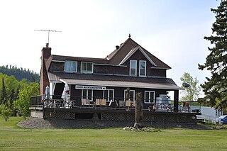
Grand Marais is a city and the county seat of Cook County, Minnesota, United States, of which it is the only municipality. It is on Lake Superior's North Shore. Grand Marais had a population of 1,337 at the 2020 census. Before it was settled by French Canadians and before Minnesota's statehood, it was inhabited by the Ojibwe.

Ely is a city in Saint Louis County, Minnesota, United States. The population was 3,268 at the 2020 census.

The Boundary Waters Canoe Area Wilderness comprises 1,090,000 acres (440,000 ha) of pristine forests, glacial lakes, and streams in the Superior National Forest. Located entirely within the U.S. state of Minnesota at the Boundary Waters, the wilderness area is under the administration of the United States Forest Service. Efforts to preserve the primitive landscape began in the 1900s and culminated in the Boundary Waters Canoe Area Wilderness Act of 1978. The area is a popular destination for canoeing, hiking, and fishing, and is the most visited wilderness in the United States.

The Iron Range is collectively or individually a number of elongated iron-ore mining districts around Lake Superior in the United States and Canada. Much of the ore-bearing region lies alongside the range of granite hills formed by the Giants Range batholith. These cherty iron ore deposits are Precambrian in the Vermilion Range and middle Precambrian in the Mesabi and Cuyuna ranges, all in Minnesota. The Gogebic Range in Wisconsin and the Marquette Iron Range and Menominee Range in Michigan have similar characteristics and are of similar age. Natural ores and concentrates were produced from 1848 until the mid-1950s, when taconites and jaspers were concentrated and pelletized, and started to become the major source of iron production.

County State-Aid Highway 12 (CSAH 12), also known as the Gunflint Trail, or County Road 12 (CR 12), is a 57-mile (92 km) paved roadway and National Scenic Byway in Cook County, Minnesota, that begins in Grand Marais and ends at Saganaga Lake in the Boundary Waters Canoe Area Wilderness (BWCAW), near the U.S. border with Ontario. It provides access to many of the entry points in the BWCAW.

Superior National Forest, part of the United States National Forest system, is located in the Arrowhead Region of the state of Minnesota between the Canada–United States border and the north shore of Lake Superior. The area is part of the greater Boundary Waters region along the border of Minnesota and the Canadian province of Ontario, a historic and important thoroughfare in the fur trading and exploring days of New France and British North America.

The North Shore of Lake Superior runs from Duluth, Minnesota, United States, at the western end of the lake, to Thunder Bay and Nipigon, Ontario, Canada, in the north, to Sault Ste. Marie, Ontario in the east. The shore is characterized by alternating rocky cliffs and cobblestone beaches, with forested hills and ridges through which scenic rivers and waterfalls descend as they flow to Lake Superior.
The Kekekabic Trail, commonly referred to as "The Kek," is a hiking trail that runs about 39 miles from Snowbank Road near Ely, Minnesota to the western terminus on the Gunflint Trail in northwestern Cook County. It connects with the Border Route Trail on its eastern terminus. The Kekekabic Trail runs through the center of the Boundary Waters Canoe Area Wilderness and begins opposite the Snowbank Trailhead on the Ely side. Most of the trail lies in Lake County. The Kekekabic is known for being very remote, primitive and rugged in nature, and for solitude.
The Border Route Trail is a 65-mile (105 km) long hiking trail that crosses the Boundary Waters Canoe Area Wilderness (BWCAW) in the far northeast corner of Minnesota (Arrowhead) and follows the international border between Minnesota and Ontario, Canada. It connects with the Superior Hiking Trail on its eastern terminus and with the Kekekabic Trail on its western end at the Gunflint Trail. In addition to the eastern and western termini, the Border Route Trail can be accessed through several spur and connecting trails, allowing for hiking trips ranging from short day-hikes to multiday backpacking expeditions. It is known for its dramatic topography, rugged nature, and outstanding vistas. Many of the vistas overlook the US - Canada border chain of lakes, also known as the Voyageur highway.
Wilderness Canoe Base is a Christian youth camp that borders the Boundary Waters Canoe Area Wilderness on Seagull Lake near the end of the Gunflint Trail, about 50 miles from Grand Marais, Minnesota, USA. The camp hosts canoe camping trips and work-service trips for youth during the summer as well as retreats for all ages year round. Part of the camp is on the northern half of Fishhook Island and another tract resides on nearby Dominion Island. It has been under the management of Lake Wapogasset Lutheran Bible Camp, Inc. since 2002.
The Northeastern Minnesota Book Awards, or the NEMBA Awards, are awards presented annually for books that "substantially represent northeastern Minnesota in the areas of history, culture, heritage, or lifestyle."
Leeblain is a ghost town in the Canadian province of Ontario, located on the north shore of Gunflint Lake in the Thunder Bay District, partly within La Verendrye Provincial Park and next to the Boundary Waters Canoe Area Wilderness in the Boundary Waters between Canada and the United States.

The Silver Mountain station is a historic railway station located in the Thunder Bay District, Ontario. It sits at the intersection of Highway 588 and Highway 593. Now operated as a restaurant, it was constructed in 1907 as a major station along the Port Arthur, Duluth and Western Railway. It is also currently home to the Silver Mountain and Area Historical Society.

North Lake is a former railway station located near North Lake, Thunder Bay District, Ontario. It lies close to La Verendrye Provincial Park and to the well known Boundary Waters Canoe Area Wilderness in the Boundary Waters between Canada and the United States. It was constructed in 1907 as a major station along the Port Arthur, Duluth and Western Railway.

The Paulson Mine is a former iron ore mine located in Cook County, Minnesota, United States, 53 kilometres north-west of Grand Marais, Minnesota near the end of the historic Gunflint Trail. The Port Arthur, Duluth and Western Railway was built to the mine in 1892 to access the ore, but both the mine and railway failed.

Canoe Country Outfitters was formed in 1946 in Ely, Minnesota, to provide canoe trip outfitting services for Quetico Provincial Park and Superior National Forest and what was to become Boundary Waters Canoe Area Wilderness (BWCAW). Bill Rom started the business and then sold it to Bob Olson Sr. in 1975. At times they have been dubbed to be the largest canoe outfitter in the world. They operate from two locations, one in downtown [ Ely, Minnesota, the other on Moose lake, about 20 miles east of Ely.

SS Onoko was an iron-hulled Great Lakes freighter. She was launched in 1882 in Cleveland, Ohio by the Globe shipbuilding firm, as its hull number #4, and sank on September 14, 1915, in Lake Superior near Knife River, Minnesota. According to the Minnesota Historical Society, Onoko is regarded as a prototype of the single-steel hulled Great Lakes bulk carrier, These vessels made possible the cheap transport of bulk cargoes such as iron ore, coal and limestone. Her wreckage still remains on the bottom of Lake Superior and was listed on the National Register of Historic Places in 1992.
Minnesota Scenic Byways are a system of roads in the U.S. state of Minnesota which pass through areas of scenic, cultural, or recreational significance. There are currently 22 scenic byways in the system with a total length of 2,948 miles (4,744 km). Eight of these byways are also designated as National Scenic Byways, and the North Shore Scenic Drive is further designated as an All-American Road.

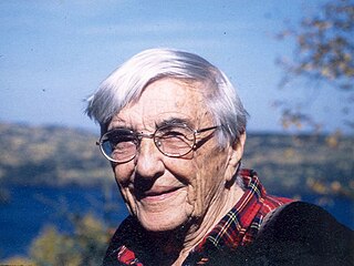
Justine Kerfoot was an American writer and outdoors-woman who moved to the Boundary Waters in Minnesota in 1927 and helped establish the Gunflint Lodge and the overall Gunflint Trail area. She was the author of two published books and co-authored a third. She also wrote a column, "On the Gunflint Trail", that ran weekly for 42 years in the Cook County News Herald.

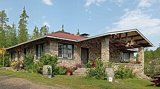
Chik Wauk Lodge, now Chik-Wauk Museum and Nature Center, is a historic building near the northern terminus of the Gunflint Trail northwest of Grand Marais, Minnesota, United States. It overlooks Saganaga Lake.


