
Gunns Plains Cave is a limestone show cave, near Gunns Plains in the North West of Tasmania, twenty kilometres from Ulverstone.
Gunns Plains Cave is a limestone show cave, near Gunns Plains in the North West of Tasmania, twenty kilometres from Ulverstone.
The cave was first entered in 1906 by a local Gunns Plains man, Bill Woodhouse, while hunting for possums. [1] A possum eluded him down a hole which led him directly to the cave. This opening served as the original entrance to the cave and early tourists needed to descend by rope from it, three stories to the cave floor. 54 steps were later constructed from concrete, leading from the natural cave floor to a new entrance cut into the hillside. This steep and narrow staircase still exists in its entirety and remains the only public entrance and exit to the cave [2] [3]
Because candlelight and torchlight were troublesome, power and fixture lighting was installed throughout to illuminate the walking track and the cave's unique features. In 2003 the system was updated to be of more benefit to visitors. [4]
As of 2004 the cave is maintained on behalf of the Tasmania Parks and Wildlife Service by Geoff and Patricia Deer, who lease the rights to manage the cave. There are daily tours. [5] The cave tour was fully re-lit using LED lighting in 2008.

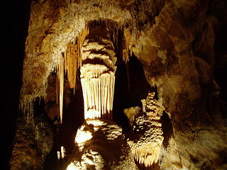
The public section of the cave runs 275 metres, is well lit and is for the most part a simple walk. Many beautiful cave formations are present, such as stalactites, stalagmites, helictites and a large array of dazzling flowstone are present in the public section of the cave.
A further one kilometre of wild cave was mapped in the early 20th century, but is more difficult to access.

The cave is a host to an assortment of wildlife. The cave is inhabited by the endangered Tasmanian Giant Freshwater Crayfish, Platypus, freshwater fish and eels. Glow worms (Arachnocampa) can be consistently found with their silk threads dangling from the ceiling. Cave crickets and spiders are also present.

Cradle Mountain-Lake St Clair National Park is located in the Central Highlands area of Tasmania (Australia), 165 kilometres (103 mi) northwest of Hobart. The park contains many walking trails, and is where hikes along the well-known Overland Track usually begin. Major features are Cradle Mountain and Barn Bluff in the northern end, Mount Pelion East, Mount Pelion West, Mount Oakleigh and Mount Ossa in the middle and Lake St Clair in the southern end of the park. The park is part of the Tasmanian Wilderness World Heritage Area.

Hartz Mountains National Park is located in the south of Tasmania, Australia. It is one of 19 Tasmanian National Parks, and in 1989 it was included in the Tasmanian Wilderness World Heritage Area, in recognition of its natural and cultural values. The Hartz Mountains were named after the Harz mountain range in Germany.

Mole Creek Karst is a national park situated in the North of Tasmania, Australia, 168 km northwest of Hobart. It is located on the slopes of the Great Western Tiers to the east of the town of Mole Creek. It is the only national park in Tasmania created specifically to protect karst landforms. It is part of the Tasmanian Wilderness World Heritage Site.

Southwest National Park is an Australian national park located in the south-west of Tasmania, bounded by the Franklin-Gordon Wild Rivers National Park to the north and the Hartz Mountains National Park to the east. It is a part of a chain of national parks and state reserves that make up the Tasmanian Wilderness World Heritage Area. Covering an area of 6,183 km2 (2,387 sq mi), it is Tasmania's largest national park.

Tunnel Creek National Park is a national park in the Kimberley region of Western Australia, 1,845 kilometres (1,146 mi) northeast of Perth and 390 km (240 mi) east of Broome. The natural cave through which Tunnel Creek flows is a major attraction of the park.

Lake St Clair or leeawulenna is a natural freshwater lake located in the Central Highlands area of Tasmania, Australia. The lake forms the southern end of the Cradle Mountain-Lake St Clair National Park. It has an area of approximately 45 square kilometres (17 sq mi), and a maximum depth of 215 metres (705 ft), making it Australia's deepest lake.

The Overland Track is an Australian bushwalking track, traversing Cradle Mountain-Lake St Clair National Park, within the Tasmanian Wilderness World Heritage Area. It's walked by more than nine thousand people each year, with numbers limited in the warmer months. Officially the track runs for 65 kilometres (40 mi) from Cradle Mountain to Lake St Clair however many choose to extend it by walking along Lake St Clair for an extra day, bringing it to 82 kilometres (51 mi). It winds through terrain ranging from glacial mountains, temperate rainforest, wild rivers and alpine plains.
The Jenolan Caves are limestone caves located within the Jenolan Karst Conservation Reserve in the Central Tablelands region, west of the Blue Mountains, in Jenolan, Oberon Council, New South Wales, in eastern Australia. The caves and 3,083-hectare (7,620-acre) reserve are situated approximately 175 kilometres (109 mi) west of Sydney, 20 kilometres (12 mi) east of Oberon and 30 kilometres (19 mi) west of Katoomba.

Albert Park and Albert Park Lake are situated in the City of Port Phillip, Victoria, Australia, 3 kilometres (1.9 mi) south of the Melbourne central business district.

Smoke Hole Caverns (SHC) is a picturesque show cave in Grant County in West Virginia's Eastern Panhandle.

Mole Creek is a town in the upper Mersey Valley, in the central north of Tasmania, Australia. Mole Creek is well known for its honey and accounts for about 35 percent of Tasmania's honey production. The locality is in the Meander Valley Council area, but with about 3% in the Kentish Council LGA.
The South Coast Track is a bushwalking track located in the South Coast region of Tasmania, Australia. The 85-kilometre (53 mi) track traverses remote wilderness within the Southwest National Park, part of the Tasmanian Wilderness World Heritage Site, and is managed as a wilderness walk. The Tasmanian Parks & Wildlife Service recommend that experienced bushwalkers can take six-to-eight days to cover the track in one direction.
Bathurst Harbour is a shallow bay located in the south west region of Tasmania, Australia. Bathurst Harbour is contained within the Port Davey/Bathurst Harbour Marine Nature Reserve, and the Southwest National Park, part of the Tasmanian Wilderness World Heritage Area.
The Dial Range is a small mountain range in northwest Tasmania, south of the town of Penguin near the coast. It extends about 14 km (9 mi) north to south and 4-5 km west to east. It is bordered on the east and south by the Leven River, with the Gunns Plains to the south.

Longhorn Cavern State Park is a state park located in Burnet County, Texas, United States. The Texas Parks and Wildlife Department is administrator of the facility. The land for Longhorn Cavern State Park was acquired between 1932 and 1937 from private owners. It was dedicated as a state park in 1932 and in 1938 was opened to the public. In 1971, the cavern was dedicated as a National Natural Landmark. The park's administration building was listed as a Recorded Texas Historic Landmark in 1989.
The Port Davey Track, officially the Old Port Davey Track, is a bushwalking track located in the south western region of Tasmania, Australia. The 70-kilometre (43 mi) track traverses remote wilderness within the Southwest National Park, part of the Tasmanian Wilderness World Heritage Site, and is managed as a wilderness walk. The Tasmanian Parks & Wildlife Service recommend that experienced bushwalkers can take four-to-five days to cover the track in one direction.

Blanche Cave, previously known as "The Big Cave", "The Old Cave" and "Mosquito Plains Cave", is one of 26 caves to be found in the Naracoorte Caves National Park, a World Heritage listed site. Blanche Cave was the first of the caves to be discovered in the Naracoorte area, having been discovered by the European settlers in 1845, and can be accessed by the public through guided tours of the site. The cave contains a number of features, including, at one time, the mummified remains of an indigenous man – remains that were stolen twice in 1861 and never returned. The location has been the site for a number of events, such as, in the early days, annual New Years parties and, much more recently, it was featured as part of the Olympic torch relay for the 2000 Summer Olympics in Sydney. Blanche Cave, along with the nearby Victoria Fossil Cave, was added to the South Australian Heritage Register in 1984.

Low Head Lighthouse is in Low Head, Tasmania, about 7 kilometres (4.3 mi) north of George Town on the east side of the mouth of the Tamar River. It was the third lighthouse to be constructed in Australia, and it is also Australia's oldest continuously used pilot station. This light is now unmanned and automated.

The Hastings Caves State Reserve is the setting of a complex of caves and a natural warm springs located 102 km (63 mi) south of Hobart, Tasmania, Australia. Newdegate Cave, the largest dolomite cave in Australia open to tourists, is a part of the complex. They are located 5 kilometres (3.1 mi) from the nearby Lune River fossil/gem centre and the Ida Bay Railway.
Gunns Plains is a small town located 20 km south of Ulverstone on the north-west coast of Tasmania, Australia.