
The Nile is a major north-flowing river in northeastern Africa. It flows into the Mediterranean Sea. The Nile is the longest river in Africa and has historically been considered the longest river in the world, though this has been contested by research suggesting that the Amazon River is slightly longer. Of the world's major rivers, the Nile is one of the smallest, as measured by annual flow in cubic metres of water. About 6,650 km (4,130 mi) long, its drainage basin covers eleven countries: the Democratic Republic of the Congo, Tanzania, Burundi, Rwanda, Uganda, Kenya, Ethiopia, Eritrea, South Sudan, Sudan, and Egypt. In particular, the Nile is the primary water source of Egypt, Sudan and South Sudan. Additionally, the Nile is an important economic river, supporting agriculture and fishing.

In Greek mythology, the naiads are a type of female spirit, or nymph, presiding over fountains, wells, springs, streams, brooks and other bodies of fresh water.

Lake Titicaca is a large freshwater lake in the Andes mountains on the border of Bolivia and Peru. It is often called the highest navigable lake in the world. Titicaca is the largest lake in South America both in terms of the volume of water and surface area.
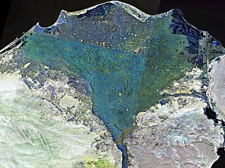
The Nile Delta is the delta formed in Lower Egypt where the Nile River spreads out and drains into the Mediterranean Sea. It is one of the world's larger deltas—from Alexandria in the west to Port Said in the east, it covers 240 km (150 mi) of Mediterranean coastline and is a rich agricultural region. From north to south the delta is approximately 160 km (100 mi) in length. The Delta begins slightly down-river from Cairo.

Glacial Lake Iroquois was a prehistoric proglacial lake that existed at the end of the last ice age approximately 13,000 years ago.

Burdur Province is a province of Turkey, located in the southwest and bordering Muğla and Antalya to the south, Denizli to the west, Afyon to the north, and Isparta to the east. Its area is 7,175 km2, and its population is 273,799 (2022). The provincial capital is Burdur city.

Enna, known from the Middle Ages until 1926 as Castrogiovanni, is a city and comune located roughly at the center of Sicily, southern Italy, in the province of Enna, towering above the surrounding countryside. It has earned the nicknames belvedere and ombelico ("navel") of Sicily.

The Jhelum River is a river in the northern Indian subcontinent. It originates at Verinag and flows through the Indian-administered territory of Jammu and Kashmir, into Pakistani-administered Azad Kashmir, then the Pakistani province of Punjab. It is the westernmost of the five rivers of the Punjab region, and flows through the Kashmir Valley. It is a tributary of the Chenab River and has a total length of about 725 kilometres (450 mi).

Lake Ohrid is a lake which straddles the mountainous border between the southwestern part of North Macedonia and eastern Albania. It is one of Europe's deepest and oldest lakes, with a unique aquatic ecosystem of worldwide importance, with more than 200 endemic species.

Lake Manasarovar, also called Mapam Yumtso locally, is a high altitude freshwater lake fed by the Kailash Glaciers near Mount Kailash in Burang County, Ngari Prefecture, Tibet Autonomous Region, China. The Indus River is near the lake. The lake along with Mount Kailash to its north are sacred sites in four religions: Hinduism, Jainism, Buddhism and Bön.
Anaua was a town of ancient Phrygia, later also known as Sanaos. It was located near a salt lake by the same name, now Lake Acıgöl. The town is located near modern Sarıkavak.

The Idaho Panhandle National Forests are a jointly administered set of three national forests located mostly in the U.S. state of Idaho. In 1973, major portions of the Kaniksu, Coeur d'Alene, and St. Joe National Forests were combined to be administratively managed as the Idaho Panhandle National Forests (IPNF). The IPNF consists of more than 2.5 million acres (10,000 km2) of public lands in the panhandle of north Idaho, with small areas extending into eastern Washington (4.7%) and western Montana (1.2%). The northernmost portion of the IPNF share a boundary with Canada. The Forest Supervisor's office is located in Coeur d'Alene, Idaho with district office's in Bonners Ferry, Sandpoint, Priest River, Fernan and Smelterville, and St. Maries and Avery.
Sugunia was the first capital of Arame of Urartu. The city was mentioned in an inscription by the Assyrian king Shalmaneser III, who destroyed it in 858 BC.
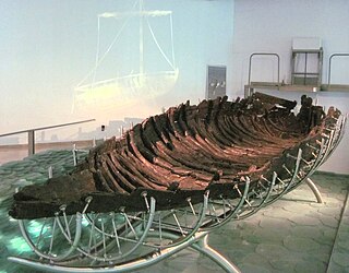
The Ancient Galilee Boat, also known as the Jesus Boat, is an ancient fishing boat from the 1st century AD, discovered in 1986 on the north-west shore of the Sea of Galilee in Israel. The remains of the boat, 27 feet long, 7.5 feet wide and with a maximum preserved height of 4.3 feet, first appeared during a drought, when the waters of the Sea receded. Other than the dating, there is no evidence connecting the boat to Jesus or his disciples.
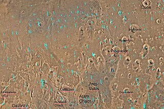
Shalbatana Vallis is an ancient water-worn channel on Mars, located in the Oxia Palus quadrangle at 7.8° north latitude and 42.1° west longitude. It is the westernmost of the southern Chryse outflow channels. Beginning in a zone of chaotic terrain, at 0° latitude and 46° W longitude, it ends in Chryse Planitia.

In summer 1965, the first close-up images from Mars showed a cratered desert with no signs of water. However, over the decades, as more parts of the planet were imaged with better cameras on more sophisticated satellites, Mars showed evidence of past river valleys, lakes and present ice in glaciers and in the ground. It was discovered that the climate of Mars displays huge changes over geologic time because its axis is not stabilized by a large moon, as Earth's is. Also, some researchers maintain that surface liquid water could have existed for periods of time due to geothermal effects, chemical composition or asteroid impacts. This article describes some of the places that could have held large lakes.

Shulgan-Tash Cave, also known as Kapova Cave, is a limestone karst cave in the Burzyansky District of Bashkortostan, Russia. It is located in the southern Ural Mountains, approximately 200 km (120 mi) south-east of Ufa. Located on the Belaya River in the natural reserve Shulgan-Tash, the cave is best known for the 16,000 years old Upper Paleolithic rock paintings and drawings. It contains the northernmost known ancient paintings.

In January 2017, scientists announced the possible discovery of mud cracks in Gale Crater on Mars. The Curiosity Rover imaged what may be the first mud cracks ever found on Mars. They may have been formed from drying mud. The site, called “Old Soaker,” was within an exposure of Murray formation mudstone on lower Mount Sharp.
Daphnus or Daphnous was a town of ancient Bithynia, situated upon an island in a lake called Daphnusis near the Mysian Olympus. The lake Daphnusis is identified as that called Miletopolitis by other authors.


