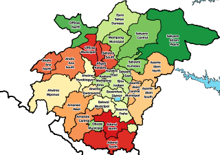
Adansi is the name of an Akan ethnic group inhabiting the Ashanti Region of Ghana. The capital of the Adansi is at Fomena. An Adansihene is still designated. The Adansi has seven paramountcies: the capital, Fomena, New Edubiase, Ayaase, Akrokyere (Akrokerri), Akrofuom, Bodwesango and, Dompoase. The Adansi is devolved into three local government divisions - Adansi South which has a population of 129,325 and an area of 1,380 square kilometres has the capital at New Edubiase; Adansi North has a population of 235,680, and an area 828 square kilometres and has its capital at Fomena; and Obuasi Municipal which has a population of 175,043 and is the second-largest urban settlement in the Ashanti Region and the eight biggest urban settlement in Ghana. Adansi South was once the largest cocoa growing area in the Ashanti Region.
New Edubiase is a small town and is the capital of Adansi South, a district in the Ashanti Region of Ghana. it was formerly called the Adansi East district in the Ashanti Region. It shares boundaries on the north with Adansi North and the northeast with the Amansie East District and on the east side shares boundary with Birim East in the Eastern Region, share boundary with Obuasi Municipal from the west and the south with Assin North in the Central Region.
Mampong Municipal Assembly is one of the forty-three districts in Ashanti Region, Ghana. Originally it was formerly part of the then-larger Sekyere West District in 1988, which was created from the former Sekyere District Council. However on 1 November 2007, the eastern part of the district was split off to create Sekyere Central District; while the remaining portion has since then been officially renamed as Mampong Municipal District, which it was elevated to municipal district assembly status on that same year. The municipality is located in the northern part of Ashanti Region and has Mampong as its capital town.
Adansi South District is one of the forty-three districts in Ashanti Region, Ghana. Originally it was created from parts of two former districts on 17 February 2004: Adansi West District and Adansi East District; thus the remaining parts had been absorbed into parts of Obuasi Municipal District and Adansi North District respectively. On 15 March 2018, the western part of the district was split off to create Akrofuom District. The district assembly is the southernmost part of Ashanti Region and has New Edubiase as its capital town.

Gorontalo is a city and the capital of the Gorontalo Province, Indonesia. It is on the island of Sulawesi. The city has an area of 79.59 km2 and had a population of 179,991 at the 2010 census and 198,539 at the 2020 census; the official estimate as at mid 2021 was 199,788.

This is a list of the extreme points of Azerbaijan, the points that are farther north, south, east or west than any other location.

Patchewollock is a town in north-west Victoria, Australia. At the 2016 census, Patchewollock had a population of 133.

Sunamganj Sadar is an upazila of Sunamganj District in the Division of Sylhet, Bangladesh.

Nanumba North Municipal District is one of the sixteen districts in Northern Region, Ghana. Originally it was formerly part of the then-larger Nanumba District in 1988, until the southern part of the district was split off to create Nanumba South District on 27 August 2004; thus the remaining part has been renamed as Nanumba North District. However on 15 March 2018, it was later elevated to municipal district assembly status to become Nanumba North Municipal District. The municipality is located in the southern part of Northern Region and has Bimbilla as its capital town.

Rail transport in Togo consists of 568 km (353 mi) (2014) of 1,000 mmmetre gauge railway.
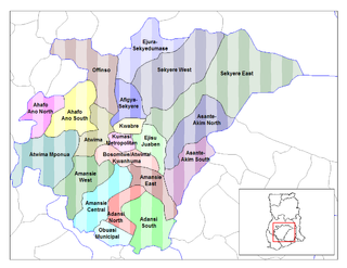
Sekyere West District is a former district that was located in Ashanti Region, Ghana. Originally created as an ordinary district assembly in 1988, which was created from the former Sekyere District Council. However on 29 February 2008, it was split off into two new districts: Mampong Municipal District and Sekyere Central District. The district assembly was located in the northern part of Ashanti Region and had Mampong as its capital town.
Ogalur is a village in Perambalur district, Tamil Nadu, India. It was formerly in Tiruchirappalli district.
Gudisagar is a village in Dharwad district of Karnataka, India.
Asesewa is a small town and the district capital of Upper Manya Krobo district in the Eastern region of southern Ghana. Asesewa is a historic trading post. It has a mix of cultures who are from all over Ghana. It is located about 45 km from the regional capital of Eastern region, Koforidua.
Bimbilla is the capital town of Nanumba North District, a district in the Northern Region of Ghana. It is located in the East of the region, and is near the Oti River.

The history of African Americans in Ghana goes back to individuals such as American civil rights activist and writer W. E. B. Du Bois, who settled in Ghana in the last years of his life and is buried in the capital, Accra. Since then, other African Americans who are descended from slaves imported from areas within the present-day jurisdiction of Ghana and neighboring states have applied for permanent resident status in Ghana. As of 2015, the number of African-American residents has been estimated at around 3,000 people, a large portion of whom live in Accra.
Kpong is a town in the Lower Manya Krobo District of the Eastern Region of Ghana and particularly noted for the Kpong Dam

Krowor Municipal District is one of the twenty-nine districts in Greater Accra Region, Ghana. Originally it was formerly part of the defunct Ledzokuku-Krowor Municipal District on 29 February 2008, until part of the district was split off to create Krowor Municipal District on 15 March 2018; thus the remaining original part has been renamed as Ledzokuku Municipal District. The municipality is located in the central part of Greater Accra Region and has Nungua as its capital town.
Adansi East District is a former district that was located in Ashanti Region, Ghana. Originally created as an ordinary district assembly in 1988, which was created from the former Adansi District Council. However on 17 February 2004, it was split out into two parts for two new districts: Adansi North District and Adansi South District. The district assembly was located in the southern part of Ashanti Region and had New Edubiase as its capital town.