Related Research Articles

The East Riding of Yorkshire, or simply East Riding or East Yorkshire, is an area in Northern England. The name is traditionally and geographically a reference to the easternmost of the three subdivisions of the traditional county of Yorkshire. The boundaries of the East Riding, the North Riding and the West Riding were historically treated as three separate areas for many cultural and legal purposes, such as having separate quarter sessions. In 1889 under the Local Government Act 1888, administrative counties were formed on the existing historic county boundaries in England, but in Yorkshire, given the vast size of the county area, three administrative county councils were created, based on the historic boundaries of the three Ridings. The East Riding County Council was the administrative local government and ceremonial county (Lieutenancy) area established for the area ; it remained in place for eighty-six years until being removed for new administrative tiers of local government.

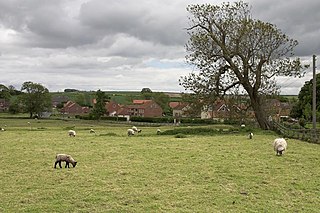
The Yorkshire Wolds are low hills in the counties of the East Riding of Yorkshire and North Yorkshire in north-eastern England. The name also applies to the district in which the hills lie.
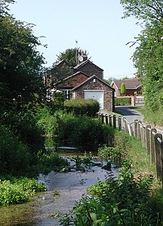
A winterbourne is a stream or river that is dry through the summer months. A winterbourne is sometimes simply called a bourne, from the Anglo-Saxon word for a stream flowing from a spring, although this term can also be used for all-year water courses.

Wold Newton is a small Yorkshire Wolds village and civil parish in the East Riding of Yorkshire, England. It is situated approximately 9 miles (14 km) south of Scarborough and 9 miles (14 km) north-west of Bridlington. Wold Newton is located within the Great Wold Valley and the course of the Gypsey Race, a winterbourne chalk stream, passes through the south of the village. The village of Fordon is also part of the civil parish of Wold Newton. According to the 2011 UK census, Wold Newton parish had a population of 337, an increase on the 2001 UK census figure of 291.
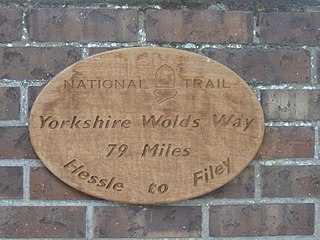
The Yorkshire Wolds Way is a National Trail in Yorkshire, England. It runs 79 miles (127 km) from Hessle to Filey, around the Yorkshire Wolds. At Filey Brigg, it connects with the Cleveland Way, another National Trail. In 2007 the Yorkshire Wolds Way celebrated the 25th anniversary of its official opening which took place on 2 October 1982.

The Wolds is a term used in England to describe a range of hills which consists of open country overlying a base of limestone or chalk.

Rudston is a small village and civil parish in the East Riding of Yorkshire, England. It is situated between Driffield and Bridlington approximately 6 miles west of Bridlington, and lies on the B1253 road. The Gypsey Race runs through the village, which lies in the Great Wold Valley. There are a number of Neolithic sites associated with the stream and its valley. It is the current Seat of the Clan Macdonald of Sleat.

Chalk streams are rivers that rise from springs in landscapes with chalk bedrock. Since chalk is permeable, water percolates easily through the ground to the water table and chalk streams therefore receive little surface runoff. As a result, the water in the streams contains little organic matter and sediment and is generally very clear. The beds of the rivers are generally composed of clean, compacted gravel and flints, which are good spawning areas for Salmonidae fish species.

Burton Fleming is a village and civil parish in the East Riding of Yorkshire, England. It lies close to the border with North Yorkshire. The village is situated approximately 7 miles (11 km) north-west of Bridlington and 6 miles (10 km) south of Filey.

West Beck is the common name given to the upper section of the old River Hull, as it rises in the foothills of the Yorkshire Wolds. After reaching Frodingham Beck at Emmotland, it becomes called the River Hull. It is noteworthy for being the most northerly chalk stream in England. It provides fly fishing for wild brown trout and grayling.

Welton is a village and civil parish in the East Riding of Yorkshire, England. The parish extends to the bank of the Humber Estuary at its southern extreme, and into the Yorkshire Wolds in the northern part. The A63 road and Hull to Selby railway line both bisect the parish east–west south of Melton and Welton.
Duggleby is a hamlet in the Ryedale district of North Yorkshire, England. It was historically part of the East Riding of Yorkshire until 1974. It is situated 20 miles (32.2 km) north-east from York and 16 miles (25.7 km) south-east from Scarborough.

Butterwick is a village and former civil parish, now in the parish of Foxholes (1.75 miles to the east, near the village of Weaverthorpe, in the Ryedale district of North Yorkshire, England. The village lies in the Great Wold Valley and the course of the winterbourne stream the Gypsey Race passes through it. Until 1974 the village lay in the historic county boundaries of the East Riding of Yorkshire. In 1931 the parish had a population of 77.

Weaverthorpe is a village and civil parish in the Ryedale district of North Yorkshire, England. It is 13 miles (21 km) south-west of Scarborough.

Helperthorpe is a village in the Ryedale district of North Yorkshire, England. The village lies in the Great Wold Valley and the course of the winterbourne stream the Gypsey Race passes through it.
East Lutton is a hamlet in the Ryedale district of North Yorkshire, England. It is situated approximately 9 miles (14 km) east from Malton, and within the Yorkshire Wolds. It is historically part of the East Riding of Yorkshire. The village of West Lutton is 0.5 miles (0.8 km) to the west. The village lies in the Great Wold Valley and the course of the winterbourne stream the Gypsey Race passes through it.
West Lutton is a village in the Ryedale district of North Yorkshire, England. It is situated approximately 9 miles (14 km) east from Malton, and within the Yorkshire Wolds. It was historically part of the East Riding of Yorkshire until 1974. The hamlet of East Lutton is 0.5 miles (0.8 km) to the east. The village lies in the Great Wold Valley and the course of the winterbourne stream the Gypsey Race passes through it.
The Great Wold Valley is the largest and broadest of the valleys cutting into the Yorkshire Wolds in northern England. It carries the Gypsey Race, an intermittent stream, which runs from its source near Wharram-le-Street eastwards along and through the northern Yorkshire Wolds to reach the sea at Bridlington.
Foxholes is a village in the Ryedale district of North Yorkshire, England, part of the civil parish of Foxholes with Butterwick. It lies where the B1249 road crosses the Great Wold Valley, 9 miles (14.5 km) south from Scarborough, 11 miles (17.7 km) north-west from Bridlington, and 7 miles (11.3 km) north-east from Sledmere. The course of the winterbourne stream the Gypsey Race passes to the south of the village.

The Gypsey Race is a winterbourne stream that rises to the east of Wharram-le-Street and flows through the villages of Duggleby, Kirby Grindalythe, West Lutton, East Lutton, Helperthorpe, Weaverthorpe, Butterwick, Foxholes, Wold Newton, Burton Fleming, Rudston and Boynton. The stream flows into the North Sea in Bridlington harbour. It is the most northerly of the Yorkshire chalk streams.
References
- ↑ Thomas Allen (1831), "12. Survey of Dickering Wapentake", A new and complete history of the county of York, 4, I.T. Hinton, p. 96
- ↑ Paul F. Greenfield; Greg Oliver, eds. (2001), Riversymposium 2000: sustaining rivers - defining the new international agenda : selected proceedings of the 3rd International Riversymposium (Brisbane, Australia, 6-8 September 2000), 43, IWA, p. 20