Related Research Articles

Blue Diamond is a census-designated place (CDP) in Clark County, Nevada, United States. The population was 268 at the 2020 census.

Lake Mead is a reservoir formed by the Hoover Dam on the Colorado River in the Southwestern United States. It is located in the states of Nevada and Arizona, 24 mi (39 km) east of Las Vegas. It is the largest reservoir in the US in terms of water capacity. Lake Mead provides water to the states of Arizona, California, and Nevada as well as some of Mexico, providing sustenance to nearly 20 million people and large areas of farmland.
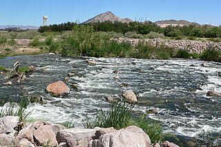
Las Vegas Wash is a 12-mile-long channel which feeds most of the Las Vegas Valley's excess water into Lake Mead. The wash is sometimes called an urban river, and it exists in its present capacity because of an urban population. The wash also works in a systemic conjunction with the pre-existing wetlands that formed the oasis of the Las Vegas Valley. The wash is fed by urban runoff, shallow ground water, reclaimed water used on parks and golf courses, and stormwater.

Las Vegas Bay is a bay at the western edge of Lake Mead in the U.S. state of Nevada. The bay is located within the Lake Mead National Recreation Area to the northeast of the city of Henderson, Nevada, near the junction of Lake Mead Drive and Lake Mead Boulevard. A public campground and boat access are available in Las Vegas Bay. Low water levels of Lake Mead have rendered the marina there inoperable, and it has moved to the Hemenway Boat Harbor, in the south end of the Boulder Basin. The launch ramp there has also been closed due to the water levels.

Temescal Creek is an approximately 29-mile-long (47 km) watercourse in Riverside County, in the U.S. state of California. Flowing primarily in a northwestern direction, it connects Lake Elsinore with the Santa Ana River. It drains the eastern slopes of the Santa Ana Mountains on its left and on its right the western slopes of the Temescal Mountains along its length. With a drainage basin of about 1,000 square miles (2,600 km2), it is the largest tributary of the Santa Ana River, hydrologically connecting the 720-square-mile (1,900 km2) San Jacinto River and Lake Elsinore watersheds to the rest of the Santa Ana watershed. However, flowing through an arid rain shadow zone of the Santa Ana Mountains, and with diversion of ground water for human use, the creek today is ephemeral for most of its length, except for runoff from housing developments and agricultural return flows.
California Wash is an arroyo tributary to the Muddy River, in Clark County, Nevada. Its mouth is at its confluence with the Muddy River over a mile southwest of Moapa and a mile and a half west of Glendale, Nevada. Its source is at an elevation of 3320 feet at the southwestern end of the Muddy Mountains, at 36°17′14″N114°48′09″W. From there it drains northeastward to its mouth on the Muddy River.
Palm Canyon Wash is an arroyo and tributary ephemeral stream or wash of the Whitewater River, in Riverside County, California.
Bull Canyon is a canyon at the top of Palm Canyon Wash, which is a tributary to the Whitewater River, in Riverside County, California. Bull Canyon and the creek of Palm Canyon Wash heads at 33°36′47″N116°33′23″W, at an elevation of 6,165 feet in the southern western slope of a ridge in the San Jacinto Mountains. The waters of the creek of Palm Canyon Wash are augmented by Bull Canyon Spring at 33°35′22″N116°33′24″W, at an elevation of 5,331 feet / 1,625 meters. The mouth of Bull Canyon is at an elevation of 4,508 feet / 1,374 meters at the head of head of Palm Canyon. The mouth of an unnamed creek flows north down from Vandeventer Flat into the head of Palm Canyon at its confluence with Palm Canyon Wash at 33°34′08″N116°31′43″W at an elevation of 4,460 feet.
Raccoon Creek is a stream in Daviess and Grundy counties in the U.S. state of Missouri. It is a tributary of Sugar Creek. The confluence is 1.5 miles southeast of the community of Brimson and 1.5 mile west of Sugar Creeks confluence with the Thompson River.
Callville Wash is an ephemeral stream or wash in Clark County, Nevada. It was named for Callville the riverport settlement founded in 1866, at its mouth where it had its original confluence with the Colorado River.
Cottonwood Spring is a spring in the Black Mountains, between the west end of Pinto Valley and Callville Wash, at an elevation of 2205 feet.
Boulder Wash is an ephemeral stream or wash in Clark County, Nevada. Its mouth is at its confluence with the Boulder Wash Cove of Lake Mead at an elevation 1,276 feet / 389 meters at when Lake Mead is at its full level. Currently as the reservoir is at a much lower level its mouth is found at approximately 36°10′07″N114°33′07″W. Its source is at 36°13′36″N114°31′22″W at an elevation of 2,841 feet / 866 meters in the Black Mountains. It flows down a canyon into the upper Pinto Valley southwestward before turning southeastward to Boulder Wash Cove.
West End Wash is an ephemeral stream or wash in Clark County, Nevada. Its mouth is at its confluence with the Callville Wash of Lake Mead at an elevation 1,250 feet / 381 meters at when Lake Mead is at its full level. Currently as the reservoir is at a much lower level its mouth is found at approximately 36°08′24″N114°42′57″W. Its source is at 36°15′55″N114°43′58″W at 3,083 feet / 940 meters in the Gale Hills.
Gale Hills, formerly considered part of the Muddy Range (1879), and later the South Muddy Mountains (1980s), are a range of hills southwest of the Muddy Mountains and about three miles north of the Boulder Basin of Lake Mead, in Clark County, Nevada. It is bounded on the east by Callville Wash; on the south by the Black Mesa lava flows; on the northwest by the valley of Gypsum Wash. Its highpoint is at 36°15′32″N114°43′12″W which lies at 3,756 feet / 1,145 meters.
Boulder Basin is the westernmost of the three basins occupied by the Lake Mead reservoir and lies within the boundaries of Clark County, Nevada and Mohave County, Arizona. It includes the area between Hoover Dam and the mouth of Boulder Canyon at Auxiliary Point. When the reservoir is full it reaches an elevation of 1,204 feet / 367 meters. It includes Las Vegas Bay, Swallow Bay, Callville Bay and Hamblin Bay.
Lake Carl Etling, elevation 4,311 feet, also called Lake Carl G. Etling and Carl Etling Lake, is located southeast of Kenton, Oklahoma in Cimarron County, Oklahoma, inside Black Mesa State Park. Fed by South Carrizo Creek, it is 159 surface acres in size and has 5 miles of shoreline. It has an average depth of 11 feet, with a maximum depth of 38 feet.
References
Coordinates: 36°07′43″N114°51′26″W / 36.12861°N 114.85722°W