This article needs additional citations for verification .(December 2009) |

Gzennaya or Igzennayen is the name of a tribe in the mountainous Rif region in northern Morocco.
This article needs additional citations for verification .(December 2009) |
Gzennaya or Igzennayen is the name of a tribe in the mountainous Rif region in northern Morocco.
The word Gzennaya comes from the Berber word "Igzennayen". Originally the tribe was known by the land of "Gzennaya" which means the land of beauty
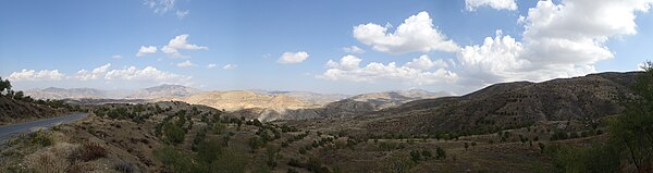
the area is well known by its high mountains (Rif Mountains), huge valleys and rivers, green woods, and its healing water of Ain Hamra.
Gzennaya has an important place in the history of Morocco. it is the birthplace of many heroes ; as well as being the birth tribe of Jaich ittahrir, the army of independence.
During the protectorate, the Gzennaya tribe defeated France in the “Triangle of Death” (Aknoul, Boured, Tizi Ousli), in October 1921, for the country's independence and the end of the protectorate. [1]
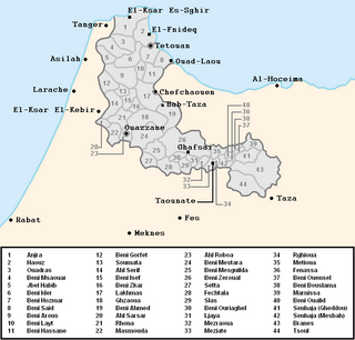
Geographically, the Igzennayen historical region extends over the modern Moroccan provinces of Taza, Al-Hoceima, Taounate, and possibly a portion of the Nador province.
The geography is characterized by its high mountains, some small fertile plains, and by a fresh Mediterranean climate.
Some notable towns and village of Gzennaya include:

Kabylia is a cultural, natural and historical region in northern Algeria and the homeland of the Kabyle people. It is part of the Tell Atlas mountain range and is located at the edge of the Mediterranean Sea.

Ouarzazate, nicknamed the door of the desert, is a city and capital of Ouarzazate Province in the region of Drâa-Tafilalet, south-central Morocco. Ouarzazate is at an elevation of 1,160 metres (3,810 ft) in the middle of a bare plateau south of the High Atlas Mountains, with a desert to the city's south.

Al Hoceima is a Riffian city in the north of Morocco, on the northern edge of the Rif Mountains and on the Mediterranean coast. It is the capital city of the Al Hoceima Province. It is situated in the territory of the Ait Ouriaghel and Ibeqquyen tribes of the Rif region, who speak a Riffian variety of the Berber language locally called Tmaziɣt (Tmazight). The city is a known tourists' destination despite its small size. It has a population of about 100,000 to 250,000.

The Spanish protectorate in Morocco was established on 27 November 1912 by a treaty between France and Spain that converted the Spanish sphere of influence in Morocco into a formal protectorate.

The Rif or Riff, also called Rif Mountains, is a geographic region in northern Morocco. This mountainous and fertile area is bordered by Cape Spartel and Tangier to the west, by Berkane and the Moulouya River to the east, by the Mediterranean to the north, and by the Ouergha River to the south. The Rif mountains are separated into the eastern Rif mountains and western Rif mountains .
The Rifains are divided into two categories:
• Arabic-speaking Rifains
• Berber speakers Rifains

Chefchaouen, also known as Chaouen, is a city in northwest Morocco. It is the chief town of the province of the same name, and is noted for its buildings in shades of blue. Chefchaouen is situated just inland from Tangier and Tétouan.

Berkane is a city in northeastern Morocco, in the tribal area of Aït Iznasen, limited by the Mediterranean to the north, the Kis river and Oujda Province in the east, Nador Province to the west, and Taourirt Province in the south. It is the capital of Berkane Province.

The Draa is Morocco's longest river, at 1,100 kilometres (680 mi). It is formed by the confluence of the Dadès River and Imini River. It flows from the High Atlas mountains, initially south-eastward to Tagounite, and from Tagounite mostly westwards to its mouth in the Atlantic Ocean somewhat north of Tan-Tan. In 1971, the (El) Mansour Eddahabi dam was constructed to service the regional capital of Ouarzazate and to regulate the flow of the Draa. Most of the year the part of the Draa after Tagounite falls dry.
The Ait Ouriaghel is one of the biggest Riffian tribes of the Rif region of the north-eastern part of Morocco and one of the most populous. Ait Waryagher means "those who do not back off/ those who do not retreat". They inhabit most of the territory around the city of Al Hoceima. The Ayt Waryaghar speak the "Western-Tarifit" dialect of the Riffian language.
The Jbala or Jebala people inhabit an area in north-west Morocco from the town of Ketema to the west. The Jbala region (from Moroccan Arabic jbāl thus occupies the western part of the Rif mountains. The Jbala population is divided into over 40 tribes, today known as ‘rural communes’, and adjacent to them are a small group of nine tribes called Ghmara , who inhabit the territory between the line of mountain peaks to the north of Chefchaouen and the Mediterranean Sea. In addition to tribal heterogeneity, this region is also geographically diverse. High mountains are interspersed with hills and flatlands, and local inhabitants settle in both the high mountains and valleys. In addition to the rainy climate, which influences the way the inhabitants build their houses as well as their special agricultural practices, there are also numerous cultural characteristics that contribute to an emphasised sense of identity and make the Jbala people clearly distinguishable from their neighbours from the eastern part of the Rif Mountains where the climate is more arid, and from the former shepherds from the Atlantic coast. There are only a few cities in the country of the Jbala, and its population remains mostly rural. During the Middle Ages, chroniclers and historians knew the Jbala under their original name - Ghumara.
Khemis Dades is a locality in Tinghir Province, Drâa-Tafilalet, Morocco. It takes its name from the day of the souk, Thursday, as well as from the Dades Valley. The commune consists of several villages or douars. Each village bears the name of the tribe that lives there, such as:

Bethioua is a town and region in the wilaya of Oran in the west of Algeria. It has a gas port, petrochemical facilities and desalination plant.

Aïn El Hammam is a town and commune in Tizi Ouzou Province in northern Algeria.

The Jbel Saghro or Djebel Sahrho is a mountain range in south- east Morocco. It is located south of the High Atlas and east of the Anti-Atlas in the northwest of Africa, northeast of Taliouine and southwest of Ouarzazate.

Jebli (Jebelia) is a pre-Hilalian Arabic dialect spoken in the mountains of northwestern Morocco.

Tanant is a small town and rural commune in Azilal Province, Béni Mellal-Khénifra, Morocco. At the time of the 2004 census, the commune had a total population of 10,007 people living in 1730 households.
Moha ou Said El Wirrawi was a Moroccan tribal leader who opposed French rule of the protectorate of Morocco. He formerly served as a caïd of the Moroccan sultans and fought for Sultan Abdelaziz against Bou Hmara in 1905. After the Treaty of Fes and the start of the French protectorate he opposed the French through military action. He participated in several battles with French forces in the Zaian War but was eventually forced into the High Atlas mountains where he died in action in 1924. His followers continued to resist the French over the next ten years.

Ait Touzine is one of the biggest Riffian tribes from the central Rif region in Morocco. The name Ait Touzine in its Berber original form is 'Ait Uzgn' meaning "The Children of the Half" perhaps implying a mixed ancestry.
N'Kob is a rural municipality in the Zagora province, in the Atlas Mountains. It is located at approximately 30°52′10.594″N5°52′1.652″W, near the Jbel Saghro and 24 kilometers from Tamsahelte. N'Kob is situated 35 kilometers west of the commune of Tazzarine and 40 kilometers from the intersection with the Draa Valley (Tansikht), the most spectacular stretch of the N9. The village has 45 Kasbahs and is surrounded by two oases full of palm trees, numerous of these ancient kasbahs have now been renovated and became hotels. The most widely spoken language in this region is Shilha (Tamazight). According to results of the 2014 general census of the population and households, the village has a population of about 7,209 people.
Ait Oulichek. is an Amazigh Riffian tribe located in the North-Eastern province of Morocco. Ayt or Beni is referred to as 'Descendants of' with the latter being the most common form of address of the Oulichek tribe until the recent Arabization in Morocco initiative.
| Tribal confederation | |
|---|---|
| Tribes | |
Coordinates: 34°44′N3°57′W / 34.733°N 3.950°W
| | This Morocco location article is a stub. You can help Wikipedia by expanding it. |