Birka, on the island of Björkö in present-day Sweden, was an important Viking Age trading center which handled goods from Scandinavia as well as many parts of Continental Europe and the Orient. Björkö is located in Lake Mälaren, 30 kilometers west of contemporary Stockholm, in the municipality of Ekerö.

Hedeby was an important Danish Viking Age trading settlement near the southern end of the Jutland Peninsula, now in the Schleswig-Flensburg district of Schleswig-Holstein, Germany. Around 965, chronicler Abraham ben Jacob visited Hedeby and described it as, "a very large city at the very end of the world's ocean."

Lake Ladoga is a freshwater lake located in the Republic of Karelia and Leningrad Oblast in northwestern Russia, in the vicinity of Saint Petersburg.
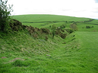
Offa's Dyke is a large linear earthwork that roughly follows the border between England and Wales. The structure is named after Offa, the Anglo-Saxon king of Mercia from AD 757 until 796, who is traditionally believed to have ordered its construction. Although its precise original purpose is debated, it delineated the border between Anglian Mercia and the Welsh kingdom of Powys.

A hillfort is a type of fortified refuge or defended settlement located to exploit a rise in elevation for defensive advantage. They are typical of the late European Bronze Age and Iron Age. Some were used in the post-Roman period. The fortification usually follows the contours of a hill and consists of one or more lines of earthworks or stone ramparts, with stockades or defensive walls, and external ditches. If enemies were approaching, the civilians would spot them from a distance.

The Geats, sometimes called Goths, were a large North Germanic tribe who inhabited Götaland in modern southern Sweden from antiquity until the Late Middle Ages. They are one of the progenitor groups of modern Swedes, along with the tribes of Swedes and Gutes. The name of the Geats also lives on in the Swedish provinces of Västergötland and Östergötland, the western and eastern lands of the Geats, and in many other toponyms.
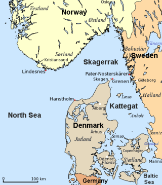
The Skagerrak is a strait running between the Jutland peninsula of Denmark, the east coast of Norway and the west coast of Sweden, connecting the North Sea and the Kattegat sea.

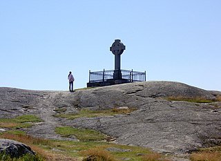
The Vordingborg Castle ruins are located in the town of Vordingborg, Denmark and are the town's most famous attraction.

A Viking ring fortress, Trelleborg-type fortress, or trelleborg, is a type of circular fort of a special design, built in Scandinavia during the Viking Age. These fortresses have a strictly circular shape, with roads and gates pointing in the four cardinal directions. Inside the fort, each quadrant has one, in a single case four, square blocks of longhouses, completing the geometric symmetry. There are a total of five confirmed Viking ring fortresses at present, located in Denmark. They have been dated to the reign of Harold Bluetooth of Denmark, with an estimated near contemporary time of construction c. 980. Their exact historical context is subject to debate. In 2023, the five Danish forts were inscribed on the UNESCO World Heritage List because of their unique architecture and testimony to the military power of the Jelling Dynasty.

The Danevirke or Danework is a system of Danish fortifications in Schleswig-Holstein, Germany. This historically important linear defensive earthwork across the neck of the Cimbrian peninsula was initiated by the Danes in the Nordic Iron Age about AD 650. It was later expanded multiple times during Denmark's Viking Age and High Middle Ages. The Danevirke was last used for military purposes in 1864 during the Second War of Schleswig.
Tucker Glacier is a major valley glacier of Victoria Land, Antarctica, about 90 nautical miles long, flowing southeast between the Admiralty Mountains and the Victory Mountains to the Ross Sea. There is a snow saddle at the glacier's head, just west of Homerun Range, from which the Ebbe Glacier flows northwestward.

The Scandinavian Peninsula became ice-free around the end of the last ice age. The Nordic Stone Age begins at that time, with the Upper Paleolithic Ahrensburg culture, giving way to the Mesolithic hunter-gatherers by the 7th millennium BC. The Neolithic stage is marked by the Funnelbeaker culture, followed by the Pitted Ware culture.

The Volga–Baltic Waterway (Волгобалт), formerly known as the Mariinsk Canal System, is a series of canals and rivers in Russia which link the Volga with the Baltic Sea via the Neva. Like the Volga–Don Canal, it connects the biggest lake on Earth, the Caspian Sea, to the World Ocean. Its overall length between Cherepovets and Lake Onega is 368 kilometres (229 mi).

Trajan's Wall is the name used for several linear earthen fortifications found across Eastern Europe, Moldova, Romania, and Ukraine. Contrary to the name and popular belief, evidence shows the ramparts were likely not built under the reign of Trajan, but later, in the period of Late Antiquity. The association with the Roman Emperor Trajan may be a recent scholarly invention of the national awakening movement of the 19th century, linking the emerging identity of the modern Romanian people to the glory of Classical Rome. Documents from medieval Moldavia referred to the earthworks as Troian, likely in reference to a mythological hero in the Romanian and Slavic folklore. The other major earthen fortification in Romania, Brazda lui Novac, is also named after a mythological hero.

A circular rampart is an embankment built in the shape of a circle that was used as part of the defences for a military fortification, hill fort or refuge, or was built for religious purposes or as a place of gathering.
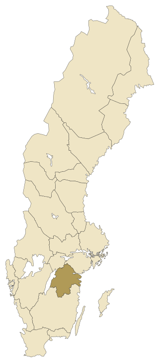
Östergötland is one of the traditional provinces of Sweden in the south of Sweden. It borders Småland, Västergötland, Närke, Södermanland and the Baltic Sea. In older English literature, the Latinized version Ostrogothia is also used. The corresponding administrative county, Östergötland County, covers the entire province and parts of neighbouring provinces.
The Salme ships are two clinker-built ships of Scandinavian origin discovered in 2008 and 2010 near the village of Salme on the island of Saaremaa, Estonia. Both ships were used for ship burials here around AD 700–750 in the Nordic Iron Age and contained the remains of 41 warriors killed in battle, as well as 6 dogs, 2 hunting hawks and numerous weapons and other artifacts.
In archaeology, a linear earthwork is a long bank of earth, sometimes with a ditch alongside. There may also be a palisade along the top of the bank. Linear earthworks may have a ditch alongside which provides the source of earth for the bank and an extra obstacle. There may be a single ditch, a ditch on both sides or no ditch at all. Earthworks range in length from a few tens of metres to more than 80 km. Linear earthworks are also known as dykes, or "ranch boundaries".
