
This is a list of local government areas (LGAs) in New South Wales, sorted by region. As of January 2023 there were 128 local government areas in New South Wales, there are 33 local government areas in Greater Sydney and 95 local government areas and 12 regions in Regional NSW. All councils are listed below in alphabetical order by region. There is also the Unincorporated Far West Region which is not part of any local government area, in the sparsely inhabited Far West, and Lord Howe Island, which is also unincorporated but self-governed by the Lord Howe Island Board.

The South Australian National Football League, or SANFL, is an Australian rules football league based in the Australian state of South Australia. It is also the state's governing body for the sport.
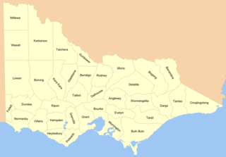
Cadastral divisions in Victoria are called counties, which are further subdivided into parishes and townships, for cadastral or land administration purposes. Cadastral divisions of county, parish and township form the basis for formal identification of the location of any piece of land in the state. There are 37 counties and 2004 parishes and 909 townships. Parishes were subdivided into sections of various sizes for sale as farming allotments, or designated as a town and then divided into sections and these subdivided into crown allotments. However, many parishes do not follow county borders, some being located in more than one county.
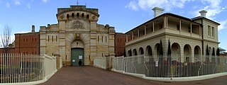
Bathurst Correctional Centre, originally built as Bathurst Gaol in 1888, is a prison for men and women located in the city of Bathurst, New South Wales, Australia, and operated by the Department of Communities and Justice. Bathurst holds inmates sentenced under State or Australian criminal law, along with a small number of remand prisoners.

Wee Jasper is a hamlet in the Yass Valley Shire in New South Wales, Australia, about 90 km north-west of Canberra and 60 km south-west of Yass. It is in the Goodradigbee valley at the western foot of the Brindabella Ranges, near Burrinjuck Dam. At the 2021 census, Wee Jasper and the surrounding area had a population of 127.
The United pastoral districts of Moreton, Wide Bay, Burnett and Maranoa, and from 1857 Moreton, Wide Bay, Burnett, Maranoa, Leichhardt and Port Curtis, was an electoral district of the Legislative Assembly in the Australian state of New South Wales created in 1856 and consisted of the pastoral districts around the early settlements of Moreton Bay; Wide Bay, near Maryborough; the Burnett River, near Bundaberg; and the Maranoa region of South-western Queensland. In September 1856 the pastoral districts around the Leichhardt River in the Gulf of Carpentaria region and Port Curtis (Gladstone) were added to the electorate. The district was abolished for the 1859 election and replaced by the separate districts of East Moreton, West Moreton, Burnett and Leichhardt, while Maranoa became part of Darling Downs. All of these districts became part of Queensland when it was established as a separate colony in late 1859.
Corindi Beach, pronounced Cor-in-"dye" although Cor-in-"dee" is widely used recently, historically also known as Pipeclay Beach until a name change in 1954, Corinda until a forced change to be provided postal service to avoid confusion or by Red Bank as Corindi River was formerly known, is a beach and small seaside farming town located on the Mid North Coast of New South Wales, Australia. The village is situated 33 kilometres (21 mi) north of Coffs Harbour and 50 kilometres (31 mi) south of Grafton. The original village of Corindi is slightly north along the Pacific Highway at Post Office Lane and Casson Close. Corindi means "grey" in local indigenous language referring to the pipeclay on the beach.
Adelaide Educational Institution was a privately run non-sectarian academy for boys in Adelaide founded in 1852 by John Lorenzo Young.
He avoided rote learning, punishment and religious instruction, but taught moral philosophy, physiology, political economy and mechanical drawing ... (and) surveying on field trips.
The Adelaide Football Club, often referred to as the Old Adelaide Football Club, was an Australian rules football club based in Adelaide. Founded on 26 April 1860, it was the first football club formed in South Australia.
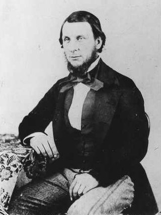
John Lorenzo Young was an English-Australian educationalist and founder of the Adelaide Educational Institution.
The Surveyor-General of Victoria is the public service officer nominally responsible for government surveying in Victoria, Australia. The original duties for the Surveyor-General were to measure and determine land grants for settlers in Victoria.. The Surveyor-General continues to be the primary government authority on surveying and the cadastre.

Isle of the Dead is an island, about 1 hectare in area, adjacent to Port Arthur, Tasmania, Australia. It is historically significant since it retains an Aboriginal coastal shell midden, one of the first recorded sea-level benchmarks, and one of the few preserved Australian convict-period burial grounds. The Isle of the Dead occupies part of the Port Arthur Historic Site, is part of Australian Convict Sites and is listed as a World Heritage Property because it represents convictism in the era of British colonisation.

Colinton is a locality in the Snowy Monaro Region, New South Wales, Australia. At the 2016 census, it had a population of 127. There was once a village and railway station of the same name.

Larbert is a locality in the Queanbeyan-Palerang Region of the Southern Tablelands region of New South Wales. It lies mostly north of the Kings Highway between Bungendore and Braidwood where it crosses the Shoalhaven River. At the 2021 census, it had a population of 34.
Cunningar is a locality in the Hilltops Council local government area, within the South West Slopes region of New South Wales, Australia. It is located immediately to the east of the town of Harden. There is a parish of the County of Harden of the same name, which comprises a part of the area of the locality.

