Location | Syria |
---|---|
Region | Aleppo Governorate |
Coordinates | 36°09′05″N38°03′43″E / 36.151446°N 38.061950°E |
History | |
Periods | Late Chalcolithic, Early Bronze, Middle Bronze |
Site notes | |
Excavation dates | 1969-1975 |
Archaeologists | Ernst Heinrich, Eva Strommenger, André Finet |
Habuba Kabira (also Hubaba Kabire and Habuba Kebira) is an ancient Near East archaeological site on the west bank of the Euphrates River in Aleppo Governorate, Syria, founded during the later part of the Uruk period in the later part of the 4th millennium BC. It was about 1300 kilometers from the southern Mesopotamia city of Uruk, five kilometers north of Tell Halawa, ten kilometers south of Mumbaqat, and eight kilometers upstream from Jebel Aruda. The site was excavated as part of a rescue archaeology effort due to the construction of the Tabqa Dam and is now mostly underwater. [1] The Habuba Kabira complex consists of two sites
Habuba Kabira North and Tell Kannas showed indications of some earlier use in the form of protoliterate clay tokens dating to the 7th through 4th millennium BC.
Habuba Kabira as a whole was in use through the Late Chacolithic period into the Middle Bronze period. Habuba Kabira South and its acropolis Tell Kannas were built in the later part of the 4th millennium BC as part of the Uruk Expansion and abandoned after about 120 years. [3] Occupation at Habuba Kabira North began in the Uruk period and continued in the Middle Bronze age. [4] [5]
There were also several other late Uruk enclaves and outposts in this general area. They include Arslantepe (attested at level VIA), Jebel Aruda (8 kilometers north near Tell es-Sweyhat), Tell Sheikh Hassan, Hacınebi Tepe, and Tepecik (Elazığ Province, attested at level 3). [6] Godin Tepe is a similar site in Iran. [7]
The low site of Hubaba Kubira South covers an area of about 18 hectares with the area encompassed by the city wall being about 10 hectares. The mound of Tell Qanas is adjacent. [6] Hubaba Kubira North is about 230 meters in diameter and rises to about 14 meters above the plain. The east and north slopes of the mound are steep while the west and south have gentle slopes. [5] It was first recorded by during surveys in 1963 and 1964 by Abdel Kader Rihaoui and Maurits N. van Loon. [8]
The Hubaba Kubira was excavated for 9 seasons from 1969 to 1975 by a Deutsche Orient-Gesellschaft team led by Ernst Heinrich and Eva Strommenger. Hubaba Kubira South was found to be a planned settlement with a three meter wide mudbrick town wall with regular towers and two gates. The town was laid out around a north-south axis with paved streets and drainage systems. The western portion of the wall was 600 meters long and a small outer wall was added late in the occupation. A walled area in the center held cultic and administrative buildings. South of the town wall there was an irrigated agricultural area. [9] [10] [11] [12] The site had at least three occupation layers, dated to the Late Chacolithic (LC 4-5) and covering about 120 years, corresponding to the Uruk V and IV periods. The first occupation, founded on virgin soil, was about 6 hectares in extent. [13] In the next phases it grew to its final extent which, including extramural habitation north and south of the wall, covered 22 hectares. [3]
Only the southeastern portion of Hubaba Kubira North was excavated as the rest of the mound was covered with a modern cemetery. A Early Bronze IV pottery kiln was found at Habuba Kabira North. Excavation found 20 occupation levels with levels 17-20 being dated to Middle Bronze IIA period. [14] [15] Small finds included clay tokens. [16] [17] [18] [19] [20] Three Uruk V period (c. 3500-3350 BC) clay tablets, called "numerical tablets" or "impressed tablets", were found at the site. [21]
Tell Qanas, the citadel area of Habuba Kubira South, was excavated beginning in 1967 by a Belgian team led by André Finet. It was occupied from from roughly 3700 BC to 3100 BC. Several large buildings were found including the tripartite plan North Temple and South Temple interior niches and basins and a large administrative building with attached magazine containing numerous storage jars. Many jar stoppers sealed with cylinder seals were found. [22] [23] [24] [25] About 58 protoliterate clay tokens were found at the site. [26]
As at Jebel Aruda and similar middle and late Uruk period sites, despite extensive excavation no Uruk period burials were found. One intrusive Early Bronze 1 tomb was found. [27]
Uruk, known today as Warka, was an ancient city in the Near East, located east of the current bed of the Euphrates River, on an ancient, now-dried channel of the river. The site lies 93 kilometers northwest of ancient Ur, 108 kilometers southeast of ancient Nippur, and 24 kilometers southeast of ancient Larsa. It is 30 km (19 mi) east of modern Samawah, Al-Muthannā, Iraq.
Shu-turul was the last king of the Akkadian Empire, ruling for 15 years according to the Sumerian king list. It indicates that he succeeded his father Dudu. A few artifacts, seal impressions etc. attest that he held sway over a greatly reduced Akkadian territory that included Kish, Tutub, Nippur, and Eshnunna. The Diyala river also bore the name "Shu-durul" at the time.
Shuruppak, modern Tell Fara, was an ancient Sumerian city situated about 55 kilometres (35 mi) south of Nippur and 30 kilometers north of ancient Uruk on the banks of the Euphrates in Iraq's Al-Qādisiyyah Governorate. Shuruppak was dedicated to Ninlil, also called Sud, the goddess of grain and the air.
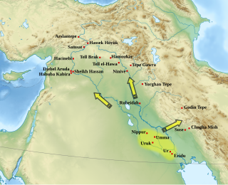
The Uruk period existed from the protohistoric Chalcolithic to Early Bronze Age period in the history of Mesopotamia, after the Ubaid period and before the Jemdet Nasr period. Named after the Sumerian city of Uruk, this period saw the emergence of urban life in Mesopotamia and the Sumerian civilization. The late Uruk period saw the gradual emergence of the cuneiform script and corresponds to the Early Bronze Age; it has also been described as the "Protoliterate period".
Theodor Wiegand was a German archaeologist.
The German Archaeological Institute is a research institute in the field of archaeology. The DAI is a "federal agency" under the Federal Foreign Office of Germany.
Kisurra was an ancient Sumerian tell situated on the west bank of the Euphrates, 7 kilometres (4.3 mi) north of Shuruppak and due east of Kish.
Albert Grünwedel was a German Indologist, Tibetologist, archaeologist, and explorer of Central Asia. He was one of the first scholars to study the Lepcha language.
Tell Chuera is an ancient Near Eastern tell site in Raqqa Governorate, northern Syria. It lies between the Balikh and Khabur rivers.
Tuttul was an ancient Near East city. Tuttul is identified with the archaeological site of Tell Bi'a in Raqqa Governorate, Syria. Tell Bi'a is located near the modern city of Raqqa and at the confluence of the rivers Balikh and Euphrates.
The Deutsche Orient-Gesellschaft, abbreviated DOG, is a German voluntary association based in Berlin dedicated to the study of the Near East.
Beveled rim bowls are small, undecorated, mass-produced clay bowls most common in the 4th millennium BC during the Late Chalcolithic period. They constitute roughly three quarters of all ceramics found in Uruk culture sites, are therefore a unique and reliable indicator of the presence of the Uruk culture in ancient Mesopotamia.
Tall Munbāqa or Mumbaqat, the site of the Late Bronze Age city of Ekalte, is a 5,000-year-old town complex in northern Syria now lying in ruins. The ruins are located on a steep slope on the east bank of the upper course of the Euphrates. In the 3rd and 2nd millennium BC the city was an important city-state in the region. Due to the establishment of the Tabqa Dam at Al-Thawrah, 35 kilometers west of Raqqa, the city ruins are partially flooded today by Lake Assad. Situated high above the steep drop of the eastern shore, Tall Munbāqa is still preserved. The Bronze Age site of Tell Hadidi (Azu) lies 5 kilometers to the north. The city-god of Ekalte was Baʿlaka. There are known to have been four temples in the city, three on the high ground by the Euphrates and one at a city gate.
Winfried Orthmann was a German archaeologist who specialised in the Near East regions.
Theodor Friedrich Heinrich von Lüpke was a German architectural historian known for his work in the field of photogrammetry.
The Royal Palace of Werla is located near Werlaburgdorf in Lower Saxony. The grounds of the royal palace cover about 20 hectares rising atop Kreuzberg hill, a 17 m high natural plateau overlooking the Oker river. In the Early Middle Ages the palace was an important place in the Holy Roman Empire, serving as an important base for the Ottonians in the 10th century in particular. Although it subsequently lost its political significance to the newly established Imperial Palace of Goslar at Rammelsberg, it developed into an independent settlement with a busy industrial quarter. In the 14th century it fell into ruin and was completely unknown until its rediscovery in the 18th century. The core fortress in particular was thoroughly excavated in the 20th century. Excavations carried out since 2007 have brought new understanding to the hitherto largely unexplored outworks. Since 2010 the palace complex with foundation and enceinte, as well as earthworks, has been partially reconstructed and is now open to the public as the Archäologie- und Landschaftspark Kaiserpfalz Werla.
Alfred Brueckner was a German classical archaeologist. He was a specialist in Greek funerary art.
Tall Bazi, is an ancient Near East archaeological site in Raqqa Governorate of Syria in the same general area as Mari and Ebla. It is located on the east bank of Euphrates river in upper Syria, about 60 kilometers south of Turkey border. It is considered a twin site to the adjacent Tell Banat Complex. Both were occupied in the 3rd and 2nd millennium BC with Banat being the focus in the early part and Bazi in the later. Tall Bazi has been proposed as the location of Armanum, known from texts of Sargon and Naram-Sin in the Akkadian period, during the reign of Naram-Sin of Akkad. It was occupied into the Mitanni period, with an occupational gap after c. 2300 BC, at which time it was destroyed. In the Late Roman Empire a large building was constructed at the top of the main mound, using the remaining Late Bronze Age fortification walls.
Julius Johann Heinrich Jordan was a German archaeologist active in Mesopotamia before and after the First World War.
Jebel Aruda, is an ancient Near East archaeological site on the west bank of the Euphrates river in Raqqa Governorate, Syria. It was excavated as part of a program of rescue excavation project for sites to be submerged by the creation of Lake Assad by the Tabqa Dam. The site was occupied in the Late Chalcolithic, during the late 4th millennium BC, specifically in the Uruk V period. It is on the opposite side of the lake from the Halafian site of Shams ed-Din Tannira and is within sight of the Uruk V site Habuba Kabira and thought to have been linked to it. The archaeological sites of Tell es-Sweyhat and Tell Hadidi are also nearby.