Mumbaqat

Last updated • 4 min readFrom Wikipedia, The Free Encyclopedia
Mumbaqat
Syria adm location map.svg
Archaeological site icon (red).svg
Shown within Syria
Alternative nameTall Munbāqa, Ekalte
Location Tabqa, Syria
Coordinates 36°13′8.97″N38°7′53.89″E / 36.2191583°N 38.1316361°E / 36.2191583; 38.1316361
Type Tell
Site notes
ArchaeologistsWinfried Orthmann, Alfred Werner Maurer
ConditionRuins
Public accessYes

Tall Munbāqa or Mumbaqat, the site of the Late Bronze Age city of Ekalte, is a 5,000-year-old town complex in northern Syria now lying in ruins.

Contents

Site

The ruins are located on a steep slope on the east bank of the upper course of the Euphrates. In the 3rd and 2nd millennium BC the city was an important city-state in the region. Due to the establishment of the Tabqa Dam at Al-Thawrah, 35 kilometers west of Raqqa, the city ruins are partially flooded today by Lake Assad. Situated high above the steep drop of the eastern shore, Tall Munbāqa is still preserved. The Bronze Age site of Tell Hadidi (Azu) lies 5 kilometers to the north. The city-god of Ekalte was Baʿlaka. [1] There are known to have been four temples in the city, three on the high ground by the Euphrates and one at a city gate. [2]

History

The Euphrates was one of the highways, Asia with the Mediterranean combined. Of course one of the main trade routes between the Sumerian and later Babylonian centers of power and the Syrian coastal cities and the immediate access to the main navigable river can be considered as one of the basic motives for founding this city. Trade was driving to urban planning. Town authorities and city destruction characterize the Urbanisationsfieber of the 3rd and 2nd millennium BC in northern Syria, where the river from the Armenian highlands turns to the south-east, 200  km from the nearby Mediterranean were major trading centers. From there, the road passes over the northern Syrian plateau of Aleppo.

Early Bronze

Starting from the 4th millennium BC, Sumerian trading sites are detectable here. In the 3rd millennium, the height of the cultural and economic development, according to the model developed chiefdom Sumerian cities.

Middle Bronze

The Old Syrian kingdom reached the 2nd millennium BC to the Euphrates. In the east was the Kingdom of Mari and in the west the Kingdom of Yahmad.

Late Bronze

Mitanni period

The Mitannistaat the Hurrians dominated a few centuries out the northeast of modern-day Syria to the Euphrates.

Hittite period

In the 14th century, BC ruled the Hittites northern Syria and the Euphrates was the boundary area between the Assyrian and Hittite Empire. Around 1200 BC settled the Syrians on the Euphrates. This eventful history may be seen from the numerous ruins of hills along the 90  km long reservoir. One of the largest excavated ruins of this ancient cultural landscape is Tall Munbāqa.

Excavations

In 1907, the English explorers William M. Ramsay and Gertrude Bell discovered the ruins, drew up a plan and described the ramparts: "Munbayah where my tents were pitched - the Arabic name means only a high-altitude course - was probably the Bersiba in Ptolemy's list of city names. It consists of a double ramparts, situated on the river bank." Though Bell was wrong in the localization of Bersiba, she did recognize the importance of the mound for the study of the oriental city.

The 400 m x 500 m, rectangular town ruins, once strongly fortified, were documented and investigated 1964, on the occasion of the inspection of the area for a proposed reservoir. The German Oriental Society requested an excavation permit for the mound in 1968. In 1969-1970, Ernst Heinrich of Technische Universität Berlin measured the visible remains and in 1971 the excavation of these remains were carried out. [3] In 1973 and 1974, excavations were led by Winfried Orthmann and in 1977 by Alfred Werner Maurer, both of the University of Saarbrücken. [4] [5] [6] From 1979 on Dittmar Machule of the Technical University of Hamburg-Harburg was the director. [7] [8] During the excavations in 1973, 1974 and 1977 up to 16 scientists and 90 local workers were involved in the excavations. Thanks to the discovery of 15 Late Bronze Age clay tablets mentioning the name of the city, it is now believed that it was known in this period as Ekalte and it has been suggested that earlier, in the Old Babylonian period, the city bore the name Yakaltum. [9]

Excavation was resumed in 1999 and continued in six seasons until 2010 under Machule and Felix Blocher. [10] [11] [12] [13] [14] [15] [16]

City gates

The 1974 excavation exposed two city gates. The East Gate is located on ♁ 36° 13' 9" N, 38° 7' 54" O36.219159 38.131635, the south gate on ♁ 36° 13' 1" N, 38° 7' 44" O36.217047 38.12891.[ citation needed ]

Related Research Articles

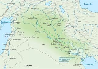
Uruk, known today as Warka, was an ancient city in the Near East, located east of the current bed of the Euphrates River, on an ancient, now-dried channel of the river. The site lies 93 kilometers northwest of ancient Ur, 108 kilometers southeast of ancient Nippur, and 24 kilometers southeast of ancient Larsa. It is 30 km (19 mi) east of modern Samawah, Al-Muthannā, Iraq.

<span class="mw-page-title-main">Waššukanni</span> Capital of the Hurrian kingdom of Mitanni

Waššukanni or Aššukanni was the capital of the Hurrian kingdom of Mitanni, from around 1500 BC to the 13th century BC.

Shuruppak, modern Tell Fara, was an ancient Sumerian city situated about 55 kilometres (35 mi) south of Nippur and 30 kilometers north of ancient Uruk on the banks of the Euphrates in Iraq's Al-Qādisiyyah Governorate. Shuruppak was dedicated to Ninlil, also called Sud, the goddess of grain and the air.

<span class="mw-page-title-main">Tell Halaf</span> Archaeological site in Syria

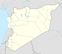
Tell Halaf is an archaeological site in the Al Hasakah governorate of northeastern Syria, a few kilometers from the city of Ras al-Ayn near the Syria–Turkey border. The site, which dates to the sixth millennium BCE, was the first to be excavated from a Neolithic culture, later called the Halaf culture, characterized by glazed pottery painted with geometric and animal designs.

<span class="mw-page-title-main">Theodor Wiegand</span> German archaeologist (1864–1936)

Theodor Wiegand was a German archaeologist.

<span class="mw-page-title-main">Tell Fekheriye</span>

Tell Fekheriye is an ancient site in the Khabur river basin in al-Hasakah Governorate of northern Syria. It is securely identified as the site of Sikkan, attested since c. 2000 BC. While under an Assyrian governor c. 1000 BC it was called Sikani. Sikkan was part of the Syro-Hittite state of Bit Bahiani in the early 1st millennium BC. In the area, several mounds, called tells, can be found in close proximity: Tell Fekheriye, Ras al-Ayn, and 2.5 kilometers east of Tell Halaf, site of the Aramean and Neo-Assyrian city of Guzana. During the excavation, the Tell Fekheriye bilingual inscription was discovered at the site, which provides the source of information about Hadad-yith'i.

<span class="mw-page-title-main">Šamuḫa</span> Bronze Age archeological site in Turkey

Šamuḫa is an ancient settlement near the village of Kayalı Pinar, c. 40 km west of Sivas, in the Sivas Province of Turkey. Located on the northern bank of Kizil Irmak river, it was a city of the Hittites, a religious centre and, for a few years, a military capital for the empire. Samuha's faith was syncretistic. Rene Lebrun in 1976 called Samuha the "religious foyer of the Hittite Empire".

Stefan Heidemann is a German orientalist at Hamburg University, Hamburg.

Kisurra was an ancient Sumerian tell situated on the west bank of the Euphrates, 7 kilometres (4.3 mi) north of Shuruppak and due east of Kish.

<span class="mw-page-title-main">Amlah</span>

Amlah or ʿAmlāʾ, al-Dhāhirah province, Sultanate of Oman. The area around Amlah contains numerous archaeological sites which came to light during surveys in the mid 1970s. Those that are available to the public date from the Bronze Age Wadi Suq period to the late pre-Islamic period. 26 excavated graves provide evidence for a cemetery at al-Fuwaydah. The graves and grave goods are related most closely to those of the United Arab Emirates, Preislamique Récente, i.e. PIR, and not the Samad Late Iron Age. Among the most striking Late Iron Age finds are bronze phiales inscribed on the inside.

Tell Chuera is an ancient Near Eastern tell site in Raqqa Governorate, northern Syria. It lies between the Balikh and Khabur rivers.

<span class="mw-page-title-main">Gottlieb Schumacher</span> American architect (1857–1925)

Gottlieb Schumacher was an American-born civil engineer, architect and archaeologist of German descent, who was an important figure in the early archaeological exploration of Palestine.

Tuttul was an ancient Near East city. Tuttul is identified with the archaeological site of Tell Bi'a in Raqqa Governorate, Syria. Tell Bi'a is located near the modern city of Raqqa and at the confluence of the rivers Balikh and Euphrates.

Stefan Clessin was a German malacologist.

The Deutsche Orient-Gesellschaft, abbreviated DOG, is a German voluntary association based in Berlin dedicated to the study of the Near East.

Habuba Kabira is an ancient Near East archaeological site on the west bank of the Euphrates River in Aleppo Governorate, Syria, founded during the later part of the Uruk period in the later part of the 4th millennium BC. It was about 1300 kilometers from the southern Mesopotamia city of Uruk, five kilometers north of Tell Halawa, ten kilometers south of Mumbaqat, and eight kilometers upstream from Jebel Aruda. The site was excavated as part of a rescue archaeology effort due to the construction of the Tabqa Dam and is now mostly underwater. The Habuba Kabira complex consists of two sites

Winfried Orthmann was a German archaeologist who specialised in the Near East regions.

<span class="mw-page-title-main">Sirkeli Höyük</span>

Sirkeli Höyük is one of the largest tells of Cilicia with an area of approximately 80 ha. It is 40 kilometers east of the city of Adana, northwest of the village Sirkeli in the district of Ceyhan, at the breakthrough of the Ceyhan through the Misis Mountains.

Tall Bazi, is an ancient Near East archaeological site in Raqqa Governorate of Syria in the same general area as Mari and Ebla. It is located on the east bank of Euphrates river in upper Syria, about 60 kilometers south of Turkey border. It is considered a twin site to the adjacent Tell Banat Complex. Both were occupied in the 3rd and 2nd millennium BC with Banat being the focus in the early part and Bazi in the later. Tall Bazi has been proposed as the location of Armanum, known from texts of Sargon and Naram-Sin in the Akkadian period, during the reign of Naram-Sin of Akkad. It was occupied into the Mitanni period, with an occupational gap after c. 2300 BC, at which time it was destroyed. In the Late Roman Empire a large building was constructed at the top of the main mound, using the remaining Late Bronze Age fortification walls.

Julius Johann Heinrich Jordan was a German archaeologist active in Mesopotamia before and after the First World War.

References

  1. Torrecilla, Eduardo, "The Dwellers of Azû: A Study on the Tall Ḥadīdī Society and Chronology", Altorientalische Forschungen, vol. 46, no. 1, pp. 33-50, 2019
  2. Otto, Adelheid, "Archaeological Evidence for Collective Governance along the Upper Syrian Euphrates during the Late and Middle Bronze Age", Organization, Representation, and Symbols of Power in the Ancient Near East: Proceedings of the 54th Rencontre Assyriologique Internationale at Würzburg 20–25 Jul, edited by Gernot Wilhelm, University Park, USA: Penn State University Press, pp. 87-100, 2012
  3. Heinrich, E., "Vierter vorläufiger Bericht über die von der Deutschen Orient-Gesellschaft mit Mitteln der Stiftung Volkswagenwerk in Habuba Kabira (Habuba Kabira, Herbstkampagnen 1971 und 1972 sowie Testgrabung Früjahr 1973) und in Mumbaqat (Tall Munbaqa, Herbstkampagne 1971) unternommenen archäolo-gischen Untersuchungen", Mitteilungen der Deutschen Orient-Gesellschaft 105, pp. 6–68, 1973
  4. W. Orthmann, Hartmut Kühne, Mumbaqat 1973, Vorläufiger Bericht über die von der Deutschen Orient-Gesellschaft mit Mitteln der Stiftung Volkswagenwerk unternommenen Ausgrabungen, In: MDOG, pp. 53–97, 1974
    • W. Orthmann, Mumbaqat 1974. Vorläufiger Bericht über die von der Deutschen Orient-Gesellschaft mit Mitteln der Stiftung Volkswagenwerk unternommenen Ausgrabungen. MDOG 108, pp. 25–44, 1976
    • Alfred Werner Maurer, Ausgrabungen 1977 in Mumbaqat am Syrischen Euphrat. Vortrag am 17. März 1978 in Berlin Schloss Charlottenburg
  5. Frank, D. R.; Machule, D.; Wittwer, U., "Tall Munbâqa 1979", MDOG 114, pp. 7-70, 1982
  6. Eichler, Seyyare, Dieter Robert Frank, Dittmar Machule, et al., "Ausgrabungen in TallMunbaqa 1983", Mitteilungen der Deutschen Orient-Gesellschaft 116, pp. 65–94, 1984
  7. Wu Yuhong, N.A.B.U. 1992/51, Dominique Charpin, N.A.B.U. 1993/32
  8. BLOCHER Felix, MACHULE Dittmar & WERNER Peter, Bericht über die Ausgrabungen in Tall Munbāqa/Ekalte 1999, Mitteilungen der Deutschen Orient-Gesellschaft, vol. 132, pp. 123-131, 2000
  9. BLOCHER Felix, MACHULE Dittmar & WERNER Peter, 2005, Bericht über die Ausgrabungen in Tall Munbāqa/Ekalte 2004, Mitteilungen der Deutschen Orient-Gesellschaft, vol.137, pp. 99-107, 2005
  10. BLOCHER Felix, MACHULE Dittmar & KARA Hans-Christian, Tall Munbāqa-Ekalte 2005: Die Geschichte geht weiter, oder: Ein Leben am Stausee, Alter Orient aktuell, vol. 7, pp. 22-27, 2006
  11. BLOCHER Felix, KARA Hans-Christian, MACHULE Dittmar & WERNER Peter, Bericht über die Ausgrabungen in Tall Munbāqa/Ekalte 2005-2007, Mitteilungen der Deutschen Orient-Gesellschaft, vol. 139, pp. 83-130, 2007
  12. BLOCHER Felix, KARA Hans-Christian, MACHULE Dittmar & WERNER Peter, Bericht über die Ausgrabungen in Tall Munbāqa/Ekalte 2008, Mitteilungen der Deutschen Orient-Gesellschaft, vol. 141, pp. 85-95, 2009
  13. BLOCHER Felix, KARA Hans-Christian & MACHULE Dittmar, Bericht über die Ausgrabungen in Tall Munbāqa/Ekalte 2010, Mitteilungen der Deutschen Orient-Gesellschaft, vol. 144, pp. 31-73, 2012
  14. Dittmar Machule & Felix Blocher Excavations at Tall Munbāqa / Ekalte (Province of Raqqa) 1999 – 2010

Further reading

See also