
The Euphrates is the longest and one of the most historically important rivers of Western Asia. Together with the Tigris, it is one of the two defining rivers of Mesopotamia. Originating in Turkey, the Euphrates flows through Syria and Iraq to join the Tigris in the Shatt al-Arab in Iraq, which empties into the Persian Gulf.

The Hurrians were a people who inhabited the Ancient Near East during the Bronze Age. They spoke the Hurrian language, and lived throughout northern Syria, upper Mesopotamia and southeastern Anatolia.

Mitanni, earlier called Ḫabigalbat in old Babylonian texts, c. 1600 BC; Hanigalbat or Hani-Rabbat in Assyrian records, or Naharin in Egyptian texts, was a Hurrian-speaking state in northern Syria and southeast Anatolia with Indo-Aryan linguistic and political influences. Since no histories, royal annals or chronicles have yet been found in its excavated sites, knowledge about Mitanni is sparse compared to the other powers in the area, and dependent on what its neighbours commented in their texts.
Shuttarna II was a king of the Hurrian kingdom of Mitanni in the early 14th century BC.

The Tabqa Dam, or al-Thawra Dam as it is also named, most commonly known as Euphrates Dam, is an earthen dam on the Euphrates, located 40 kilometres (25 mi) upstream from the city of Raqqa in Raqqa Governorate, Syria. The city of Al-Thawrah is located immediately south of the dam. The dam is 60 metres (200 ft) high and 4.5 kilometres (2.8 mi) long and is the largest dam in Syria. Its construction led to the creation of Lake Assad, Syria's largest water reservoir. The dam was constructed between 1968 and 1973 with help from the Soviet Union. At the same time, an international effort was made to excavate and document as many archaeological remains as possible in the area of the future lake before they would be flooded by the rising water. When the flow of the Euphrates was reduced in 1974 to fill the lake behind the dam, a dispute broke out between Syria and Iraq that was settled by intervention from Saudi Arabia and the Soviet Union. The dam was originally built to generate hydroelectric power, as well as irrigate lands on both sides of the Euphrates. The dam has not reached its full potential in either of these objectives.

Emar, is an archaeological site at Tell Meskene in the Aleppo Governorate of northern Syria. It sits in the great bend of the mid-Euphrates, now on the shoreline of the man-made Lake Assad near the town of Maskanah.
Šauštatar was the King of Mitanni in the fifteenth century BC. He significantly expanded the Mitanni Empire to include Assyria and Nuzi in the east to Alalakh and Kizzuwatna in the west. He was in conflict with Thutmose III competing for territory in Syria.
Tell Fekheriye is an ancient site in the Khabur river basin in al-Hasakah Governorate of northern Syria. It is securely identified as the site of Sikkan, attested since c. 2000 BC. While under an Assyrian governor c. 1000 BC it was called Sikani. Sikkan was part of the Syro-Hittite state of Bit Bahiani in the early 1st millennium BC. In the area, several mounds, called tells, can be found in close proximity: Tell Fekheriye, Ras al-Ayn, and 2.5 kilometers east of Tell Halaf, site of the Aramean and Neo-Assyrian city of Guzana. During the excavation, the Tell Fekheriye bilingual inscription was discovered at the site, which provides the source of information about Hadad-yith'i.

Lake Assad is a reservoir on the Euphrates in Raqqa Governorate, Syria. It was created in 1974 when construction of the Tabqa Dam was completed. Lake Assad is Syria's largest lake, with a maximum capacity of 11.7 cubic kilometres (2.8 cu mi) and a maximum surface area of 525 square kilometres (203 sq mi). A vast network of canals uses water from Lake Assad to irrigate lands on both sides of the Euphrates. In addition, the lake provides drinking water for the city of Aleppo and supports a fishing industry. The shores of Lake Assad have developed into important ecological zones.
Artatama I was a king of the Hurrian kingdom of Mitanni in the late fifteenth century BC. His reign coincided with the reigns of Egyptian pharaohs Amenhotep II and Thutmose IV. He is believed to be the son of earlier Mitanni king Shaushtatar.
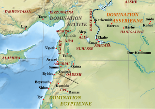
Nuhašše, was a region in northwestern Syria that flourished in the 2nd millennium BC. It was east of the Orontes River bordering Aleppo (northwest) and Qatna (south). It was a petty kingdom or federacy of principalities probably under a high king. Tell Khan Sheykhun has tenatively been identified as kurnu-ḫa-šeki.

Terqa is an ancient city discovered at the site of Tell Ashara on the banks of the middle Euphrates in Deir ez-Zor Governorate, Syria, approximately 80 kilometres (50 mi) from the modern border with Iraq and 64 kilometres (40 mi) north of the ancient site of Mari, Syria. Its name had become Sirqu by Neo-Assyrian times.
Tell es-Sweyhat is the name of a large archaeological site on the Euphrates River in northern Syria. It is located in Raqqa Governorate roughly 95 km northeast of Aleppo and 60 km south of Carchemish. Also, a Uruk site of Jebel Aruda and a Bronze Age site Tell Hadidi (Azu) are located just across the river.
The Tishrin Dam is a dam on the Euphrates, located 90 kilometres (56 mi) east of Aleppo in Aleppo Governorate, Syria. The dam is 40 metres (130 ft) high and has 6 water turbines capable of producing 630 MW. Construction lasted between 1991 and 1999. Rescue excavations in the area that would be flooded by the dam's reservoir have provided important information on ancient settlement in the area from the Pre-Pottery Neolithic A (PPNA) period upward.
Habuba Kabira is an ancient Near East archaeological site on the west bank of the Euphrates River in Aleppo Governorate, Syria, founded during the later part of the Uruk period in the later part of the 4th millennium BC. It was about 1,300 km (810 mi) from the southern Mesopotamia city of Uruk, 5 km (3.1 mi) north of Tell Halawa, 10 km (6.2 mi) south of Mumbaqat, and 8 km (5.0 mi) upstream from Jebel Aruda. The site was excavated as part of a rescue archaeology effort due to the construction of the Tabqa Dam and is now mostly underwater. The Habuba Kabira complex consists of two sites
Tell Fray is a tell, or settlement mound, on the east bank of the Euphrates in Raqqa Governorate, northern Syria. The archaeological site takes its name from an ancient irrigation canal, hence 'Fray' or 'Little Euphrates'. It was part of a rescue excavation project for sites to be submerged by the creation of Lake Assad by the Tabqa Dam.
Tall Munbāqa or Mumbaqat, the site of the Late Bronze Age city of Ekalte, is a 5,000-year-old town complex in northern Syria now lying in ruins.

Tell Taban is an archaeological site in north-eastern Syria in the Al-Hasakah Governorate. It is the site of the ancient city of Ṭābetu.
Tall Bazi, is an ancient Near East archaeological site in Raqqa Governorate of Syria in the same general area as Mari and Ebla. It is located on the east bank of Euphrates river in upper Syria, about 60 kilometers south of Turkey border. It is considered a twin site to the adjacent Tell Banat Complex. Both were occupied in the 3rd and 2nd millennium BC with Banat being the focus in the early part and Bazi in the later. Tall Bazi has been proposed as the location of Armanum, known from texts of Sargon and Naram-Sin in the Akkadian period, during the reign of Naram-Sin of Akkad. It was occupied into the Mitanni period, with an occupational gap after c. 2300 BC, at which time it was destroyed. In the Late Roman Empire a large building was constructed at the top of the main mound, using the remaining Late Bronze Age fortification walls.
Jebel Aruda, is an ancient Near East archaeological site on the west bank of the Euphrates river in Raqqa Governorate, Syria. It was excavated as part of a program of rescue excavation project for sites to be submerged by the creation of Lake Assad by the Tabqa Dam. The site was occupied in the Late Chalcolithic, during the late 4th millennium BC, specifically in the Uruk V period. It is on the opposite side of the lake from the Halafian site of Shams ed-Din Tannira and is within sight of the Uruk V site Habuba Kabira and thought to have been linked to it. The archaeological sites of Tell es-Sweyhat and Tell Hadidi are also nearby.
