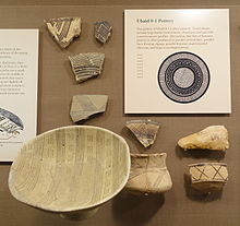
Godin Tepe

Last updated
Ceramic bowl with painted decoration from Godin Tepe, Iran; 1450-1150 BC Cuenco de Ceramica (Godin Tepe, Iran) - MARQ.jpg
Ceramic bowl with painted decoration from Godin Tepe, Iran; 1450–1150 BC
Godin Tepe
Iran location map.svg
Red pog.svg
Godin Tepe
Location in Iran
Coordinates: 34°31′00″N48°04′00″E / 34.51667°N 48.06667°E / 34.51667; 48.06667

Godin Tepe is an archaeological site in western Iran, located in the valley of Kangavar in Kermanshah province. The importance of the site may have been due to its role as a trading outpost in the early Mesopotamian trade networks.

Contents

History

The earliest evidence for occupation at Godin comes from Periods XI through VII, spanning the Early and Middle Chalcolithic. The site was already inhabited as early as c. 5200 BC.

Seh Gabi

Important sites in the Near East during the Ubaid period. Seh Gabi on the right also marks the location of Godin Tepe. Neolitico ceramico, calcolitico e bronzo antico nel Vicino Oriente.jpg
Important sites in the Near East during the Ubaid period. Seh Gabi on the right also marks the location of Godin Tepe.

Because Godin has such a deep stratigraphy, it was decided that a related site of Seh Gabi nearby should also be studied. Seh Gabi is located 6 km northeast of Godin Tepe in the Kangavar valley. The deeper levels were easier to reach there.

Originally, the excavations at Godin concentrated on levels II (ended c. 500 BC?) to V (c. 3200 BC–3000 BC), but the transition from the Neolithic to Chalcolithic was studied primarily at Seh Gabi. [1]

The earliest pottery found was of the painted pottery traditions, including J ware (Godin pre-XI) related to Halaf culture pottery. [2] The impressed Dalma ware (Dalma Tepe) (Godin XI/X) is very similar to the pottery traditions from the highlands north of Godin, especially from the area of Lake Urmia. [3]

Nadali Beig (Nad Ali Beig) is another prehistoric site located to the northwest of Godin in this Kangavar area. It also features Dalma pottery. [4] [5]

Level VIII

Ubaid pottery (Ubaid 0-1 levels) at the Oriental Institute Museum, Chicago Ubaid 0-1 pottery - Oriental Institute Museum, University of Chicago - DSC06926.JPG
Ubaid pottery (Ubaid 0-1 levels) at the Oriental Institute Museum, Chicago

Level VIII is dated 42004000 BC, contemporary with Terminal Ubaid period. According to Mitchell Rothman, at this time, during the Late Chalcolithic 1 period (LC 1), some substantial trading networks emerged in the area for trade in metals, and in precious or semi-precious stones,

"During the time of Godin VIII, the LC 1, a real increase in the movement of these goods is evident across the region. For example, lapis lazuli, a semi-precious blue stone known to occur naturally only in the Badakshan area of northeastern Afghanistan, began to appear in LC1 sites in significant amounts (Herman 1968)." [6]

Thus, the importance of Godin Tepe may have been due to its position serving the early trade from the east, from as far as Afghanistan, and to the Mesopotamian flood plain. For example, lapis-lazuli was brought from Badakhshan in Afghanistan to Mesopotamia.

Level VI/V

Goblet and cup, Iran, from Susa, 4th millennium BC - Ubaid period; goblet height c. 12 cm; Sevres - Cite de la ceramique, France Iran epoque d'Obeid Sevres.jpg
Goblet and cup, Iran, from Susa, 4th millennium BC - Ubaid period; goblet height c. 12 cm; Sèvres – Cité de la céramique, France
Archaeological plan of Godin Tepe V settlement Godin tape.jpg
Archaeological plan of Godin Tepe V settlement

During the 1973 campaign, level V was excavated through a deep cut from the citadel. It was occupied during the period 32003000 BC. At the end of level V there was a clear gap in the settlement sequence. There were signs of fire, such as room 22 whose roof was burned. The houses were in general well-preserved and contained many artefacts, but objects made of the precious metal were lacking. The archaeological evidence support the idea the settlement was abandoned quickly, but in an orderly manner. Just prior to that, in the final phases of Level VI a large architectural feature dubbed the "Oval Enclosure" was uncovered. [7]

The pottery of level V show influences from the Uruk culture, with parallels at Susa, Uruk (IV) and Nippur [8] The typical Jemdet Nasr tall storage jars, known from Nippur, and the bevelled rim bowls of Uruk are missing however. [9]

Cuyler-Young suggested the existence of Elamite trading posts at the site during this period, established by merchants from Susa. [10]

Thirteen seal impressions and two cylinder seals were found at level V. They were obviously produced locally, as shown by the discovery of an uncarved cylinder. The seal impressions show a parallel with Uruk, Susa and other sites in Khuzestan. They were partly decorated with drill holes. Steatite served as raw material for these, sometimes treated with tempering.

At level V some 43 clay tablets were found of which 27 were preserved in one piece. They contained primarily accounts, like those discovered at temporary Proto-Elamite and Uruk period sites in western Iran and Mesopotamia. [11]

Early wine-making

Traces of wine and beer found in ceramics dated to c. 31002900 BC [12] and along with the findings at Hajji Firuz Tepe, provide evidence of the early production of those beverages in the Zagros Mountains. [13] Some Kura–Araxes culture potsherds also seem to appear in association with wine making. [14]

Level IV

Level IV (30002650 BC) represents the "invasion" of the northern Yanik-culture (or "Transcaucasian Early Bronze I culture", also known as Kura–Araxes culture), well known from Yanik Tepe, Iran, near Lake Urmia. (Nevertheless, some other Kura-Araxes potsherds were found in yet deeper layers going back to late fourth millennium BC.) [15]

The only notable architectural remains of this period consist of a number of plastered hearths. T. Cuyler Young Jr. defined three main groups of pottery for Level IV. Two of these groups belong to Transcaucasian Early Bronze Age Culture. One of these groups bears two types of coarse ware tempered with coarse grit. One of these types is characterized by a grey-black burnished surface mostly with contrasting colours in the interior and exterior of the vessels. This type of coarse ware was used for producing bowls entirely. Conical bowls decorated with incised and excised designs are common; the incised designs are occasionally filled with a whitish paste. The second type of coarse ware is lighter in colour, often tan or pinkish buff. The surface of the vessels is either burnished or plain. Besides bowls there are jars with protruding rims and concave or recessed necks. [16]

The second group of Transcaucasian Pottery found at Godin Tepe was classified as Common Ware. The fabric of this group was tempered by medium-fine grit and was not well-fired. This group of pottery has the same colour range like the coarse ware. The surfaces are highly burnished though the vessels with a light interior and dark exterior are predominant. The forms consist entirely of cups, including the recessed neck types. The decoration is similar in style and technique to the previous coarse wares, but the excised designs are less common. [17]

Level III

Vessel with painted decoration from Godin Tepe, Iran. Ca. 1450-1150 BC Vaso con decoracion pintada (Godin Tepe, Iran) - MARQ.jpg
Vessel with painted decoration from Godin Tepe, Iran. Ca. 1450–1150 BC

Level III (c. 26001500/1400 BC) shows connections with Susa and most of Luristan, and it has been suggested that it belonged to the Elamite confederacy. [18] [19] A pottery link to Lagash has been established which may affect the chronology of this layer. [20] Near 1400 BC, Godin Tepe was abandoned and was not re-occupied until c. 750 BC.

Level II

Level II is represented by a single structure, a fortified, mud brick walled architectural complex (133 m x 55 m) occupied by a Mede chief. The columned halls are in the same architectural tradition of the later Persian halls (Pasargadae, Susa, Persepolis), first documented at Hasanlu (V). The Level II pottery (only wheel-made micaceous buff ware) have strong parallels with Iron Age sites as Bābā Jān Tepe(I), Jameh Shuran (IIa), Tepe Nush-i Jan and Pasargadae.

Godin was again abandoned during the 6th century BC, perhaps as a result or in anticipation of the expansion of Cyrus the Great (c. 550 BC) (Brown 1990) or due to the interruption of a social stratification and secondary State formation process after the fall of Assyria. [21]

Level I

A late, Islamic shrine (c. 15th century).

Excavations

Discovered in 1961, the site was excavated from 1965 to 1973 by a Canadian expedition headed by T. Cuyler Young Jr. and sponsored by the Royal Ontario Museum (Toronto, Canada). [22] [23] [24] [25] [26]

See also

Notes

  1. Rothman, Mitchell S.; Badler, Virginia (2011). On the High Road: The History of Godin Tepe, Iran (Chapter 2) (PDF). Mazda Publishers. p. 2. ISBN   978-1568591650. Because Godin was such a deep site and it was clear it was difficult to reach these early levels in 1971 and 1973 the Godin Project conducted excavations at Seh Gabi, a Neolithic to Chalcolithic site some six kilometers northeast of Godin in the Kangavar valley.
  2. Mitchell S. Rothman and Virginia Badler, On the High Road: The History of Godin Tepe, Iran. Chapter 4. Contact and Development in Godin Period VI. Mazda Publishers, 2011 ISBN   1568591659
  3. Henrickson, Elizabeth, 1989, Ceramic Evidence for Cultural Interaction between the ‘Ubaid Tradition and the Central Zagros Highlands, Western Iran. In: Upon This Foundation: the ‘Ubaid Reconsidered. Edited by E. Henrickson and I. Thuesen. 368–403. Copenhagen: Museum Tusculanum Press
  4. Hanan Bahranipoor 2023, NEW RADIOCARBON DATES FOR THE MIDDLE CHALCOLITHIC PERIOD OF THE CENTRAL ZAGROS, IRAN. https://doi.org/10.1017/RDC.2023.41
  5. Regional map of archaeological sites. in Steve Renette 2022, Defining Dalma: an Incipient Mountain Identity? https://doi.org/10.4000/paleorient.1699
  6. Mitchell S. Rothman and Virginia Badler, On the High Road: The History of Godin Tepe, Iran. Chapter 4. Contact and Development in Godin Period VI. Mazda Publishers, 2011 ISBN   1568591659
  7. Desset, F. “AN ARCHITECTURAL PATTERN IN LATE FOURTH-MILLENNIUM BC WESTERN IRAN: A NEW LINK BETWEEN SUSA, TAL-I MALYAN, AND GODIN TEPE.” Iran, vol. 52, 2014, pp. 1–18
  8. HilaryGopnik, A view from the east: The Godin VI Oval and the Uruk Sphere, Journal of Archaeological Science: Reports, vol. 7, pp. 835-848, June 2016
  9. V. R. Badler, A Chronology of Uruk Artifacts from Godin Tepe in Central Western Iran and Implications for the Interrelationships between the Local and Foreign Cultures." In Artefacts of Complexity: Tracking the Uruk in the Near East, edited by J. N. Postgate, pp. 79-109. Iraq Archaeological Reports 5, British School of Archaeology in Iraq, 2002
  10. Philip D. Curtin, Cross-Cultural Trade in World History: Studies in Comparative World History. Cambridge University Press, 1984 ISBN   0521269318 p65
  11. Hallo, William W. "Godin Tepe: The Inscriptions.", Yale University, (2011)
  12. Gately, Iain (2009). Drink: A Cultural History of Alcohol . New York: Gotham Books. p.  3. ISBN   978-1-592-40464-3.
  13. R. Phillips A Short History of Wine pg 2-3 Harper Collins 2000 ISBN   0-06-621282-0
  14. Rothman, Mitchell S. (2015). "Early Bronze Age migrants and ethnicity in the Middle Eastern mountain zone". Proceedings of the National Academy of Sciences. 112 (30): 9190–9195. Bibcode:2015PNAS..112.9190R. doi: 10.1073/pnas.1502220112 . PMC   4522795 . PMID   26080417.
  15. Rothman, Mitchell S. (2015). "Early Bronze Age migrants and ethnicity in the Middle Eastern mountain zone". Proceedings of the National Academy of Sciences. 112 (30): 9190–9195. Bibcode:2015PNAS..112.9190R. doi: 10.1073/pnas.1502220112 . PMC   4522795 . PMID   26080417.
  16. T. Cuyler Young Jr., "The Chronology of the Late Third and Second Millennia in Central Western Iran as Seen from Godin Tepe", American Journal of Archaeology vol. 73, no. 3, pp. 287–291, 1969
  17. Sagona, A.G.; The Caucasian Region in the Early Bronze Age Part I–III, BAR International Series 214(i), Oxford, 1984. ISBN   0-86054-277-7
  18. Robert Carl Henrickson, Godin Tepe, Godin III, and Central Western Iran: C. 26001500 BC, University of Toronto dissertation, 1984 (PDF available at Tspace.library.utoronto.ca)
  19. Robert C. Henrickson, A Regional Perspective on Godin III Cultural Development in Central Western Iran, Iran, vol. 24, pp. 1-55, 1986
  20. Steve Renette, Painted Pottery from Al-Hiba: Godin Tepe III Chronology and Interactions between Ancient Lagash and Elam, Iran, vol. 53, iss. 1, pp. 49–63, 2015
  21. Heleen Sancisi-Weerdenburg, Was There Ever a Median Empire?, pp. 197–212 in Method and Theory. Proceedings of the London 1985 Achaemenid History Workshop. (Achaemenid History III) A. Kuhrt, H. Sancisi-Weerdenburg (eds.), Leiden (1988, ISBN   978-90-6258-403-1
  22. Hilary Gopnik and Mitchell S. Rothman, "On the High Road: The History of Godin Tepe", Iran, Mazda Pub, 2011, ISBN   978-1568591650
  23. H.Gopnik Godin Tepe TSpace Web Archive
  24. T. Cuyler Young Jr, "Excavations at Godin Tepe. First Progress Report", Royal Ontario Museum Occasional Paper 17, 1969
  25. T. Cuyler Young Jr and Louis D. Levine, "Excavations at Godin Tepe. Second Progress Report", Royal Ontario Museum Occasional Paper 26, 1974, ISBN   0-88854-019-1
  26. Archived 2010-07-21 at the Wayback Machine Harvey Weiss and T. Cuyler Young Jr, "Merchants of Susa: Godin V and plateau-lowland relations in the late Fourth Millennium BC", Iran, vol. 13, pp. 1–17, 1975

Related Research Articles

<span class="mw-page-title-main">Susa</span> Ancient city in Iran

Susa was an ancient city in the lower Zagros Mountains about 250 km (160 mi) east of the Tigris, between the Karkheh and Dez Rivers in modern day Iran. One of the most important cities of the Ancient Near East, Susa served as the capital of Elam and the winter capital of Achaemenid Empire, and remained a strategic centre during the Parthian and Sasanian periods.

<span class="mw-page-title-main">Kura–Araxes culture</span> Archaeological culture from the Caucasus region

The Kura–Araxes culture was an archaeological culture that existed from about 4000 BC until about 2000 BC, which has traditionally been regarded as the date of its end; in some locations it may have disappeared as early as 2600 or 2700 BC. The earliest evidence for this culture is found on the Ararat plain; it spread north in the Caucasus by 3000 BC.

<span class="mw-page-title-main">Uruk period</span> Archaeological culture

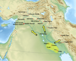
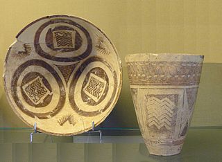
The Uruk period existed from the protohistoric Chalcolithic to Early Bronze Age period in the history of Mesopotamia, after the Ubaid period and before the Jemdet Nasr period. Named after the Sumerian city of Uruk, this period saw the emergence of urban life in Mesopotamia and the Sumerian civilization. The late Uruk period saw the gradual emergence of the cuneiform script and corresponds to the Early Bronze Age; it has also been described as the "Protoliterate period".

<span class="mw-page-title-main">Proto-Elamite (period)</span> Historical period of Iranian civilization (c. 3200–2700 BCE)

The Proto-Elamite period, also known as Susa III, is a chronological era in the ancient history of the area of Elam, dating from c. 3100 BC to 2700 BC. In archaeological terms this corresponds to the late Banesh period. Proto-Elamite sites are recognized as the oldest civilization in the territory of present-day Iran. The Proto-Elamite script is an Early Bronze Age writing system briefly in use before the introduction of Elamite cuneiform.

<span class="mw-page-title-main">Teppe Hasanlu</span>

Teppe Hasanlu or Hasanlu Tepe is an archeological site of an ancient city located in northwest Iran, a short distance south of Lake Urmia. The nature of its destruction at the end of the 9th century BC essentially froze one layer of the city in time, providing researchers with extremely well preserved buildings, artifacts, and skeletal remains from the victims and enemy combatants of the attack. The site was likely associated with the Mannaeans.

Tepe Sialk is a large ancient archeological site in a suburb of the city of Kashan, Isfahan Province, in central Iran, close to Fin Garden. The culture that inhabited this area has been linked to the Zayandeh River Culture.

Tapeh Yahya is an archaeological site in Kermān Province, Iran, some 220 kilometres (140 mi) south of Kerman city, 90 kilometres (56 mi) south of Baft city and 90 km south-west of Jiroft. The easternmost occupation of the Proto-Elamite culture was found there.

Aratashen is a town in the Armavir Province of Armenia. It is located on the Ararat Plain.

Hajji Firuz Tepe is an archaeological site located in West Azarbaijan Province in north-western Iran and lies in the north-western part of the Zagros Mountains. The site was excavated between 1958 and 1968 by archaeologists from the University of Pennsylvania Museum of Archaeology and Anthropology. The excavations revealed a Neolithic village that was occupied in the second half of the sixth millennium BC where some of the oldest archaeological evidence of grape-based wine was discovered in the form of organic residue in a pottery jar.

<span class="mw-page-title-main">Shengavit (site)</span> Archaeological site in present-day Yerevan, Armenia

The Shengavit Settlement is an archaeological site in present-day Yerevan, Armenia located on a hill south-east of Yerevan Lake. It was inhabited during a series of settlement phases from approximately 3000 BC cal to 2500 BC cal in the Kura–Araxes (Shengavitian) period of the Early Bronze Age and irregularly re-used in the Middle Bronze Age until 2200 BC cal. The town occupied an area of six hectares. It appears that Shengavit was a societal center for the areas surrounding the town due to its unusual size, evidence of surplus production of grains, and metallurgy, as well as its monumental 4 meter wide stone wall. Three smaller village sites of Moukhannat Tepe, Khorumbulagh, and Tairov have been identified and were located outside the walls of Shengavit. Its pottery makes it a type site of the Kura-Araxes or Early Transcaucasian Period and the Shengavitian culture area.

Choghā Mīsh (Persian language; چغامیش čoġā mīš) dating back to about 6800 BC, is the site of a Chalcolithic settlement located in the Khuzistan Province Iran on the eastern Susiana Plain. It was occupied at the beginning of 6800 BC and continuously from the Neolithic up to the Proto-Literate period, thus spanning the time periods from Archaic through Proto-Elamite period. After the decline of the site about 4400 BC, the nearby Susa, on the western Susiana Plain, became culturally dominant in this area. Chogha Mish is located just to the east of Dez River, and about 25 kilometers to the east from the ancient Susa. The similar, though much smaller site of Chogha Bonut lies six kilometers to the west.

Tureng Tepe is a Neolithic and Chalcolithic archaeological site in northeastern Iran, in the Gorgan plain, approximately 17 km northeast of the town of Gorgan. Nearby is a village of Turang Tappeh.
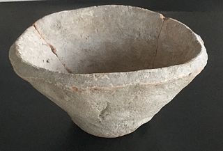
<span class="mw-page-title-main">Prehistory of Iran</span>

The prehistory of the Iranian plateau, and the wider region now known as Greater Iran, as part of the prehistory of the Near East is conventionally divided into the Paleolithic, Epipaleolithic, Neolithic, Chalcolithic, Bronze Age and Iron Age periods, spanning the time from the first settlement by archaic humans about a million years ago until the beginning of the historical record during the Neo-Assyrian Empire, in the 8th century BC.

<span class="mw-page-title-main">Leyla-Tepe culture</span>

The Leyla-Tepe culture of the South Caucasus belongs to the Chalcolithic era. It got its name from the site in the Agdam District of modern-day Azerbaijan. Its settlements were distributed on the southern slopes of Central Caucasus, from 4350 until 4000 B.C.

The Halaf-Ubaid Transitional period or HUT is a prehistoric period of Mesopotamia. It lies chronologically between the Halaf period and the Ubaid period. It is still a complex and rather poorly understood period. At the same time, recent efforts were made to study the gradual change from Halaf style pottery to Ubaid style pottery in various parts of North Mesopotamia.

<span class="mw-page-title-main">Bābā Jān Tepe</span> Village in Lorestan, Iran

Bābā Jān Tepe (Tappa), an archeological site in north-eastern Lorestan Province, on the southern edge of the Delfān plain at approximately 10 km from Nūrābād, important primarily for excavations of first-millennium BC levels conducted by C. Goff from 1966-69. Work concentrated on two mounds joined by a saddle. The East Mound yielded a series of first-millennium BC buildings above Bronze Age graves. On the Central Mound, excavation concentrated on the Baba Jan III Manor on the summit; an 8 x 6 m Deep Sounding provides a partial late fourth- to mid-second-millennium BC sequence

Kul Tepe Jolfa is an ancient archaeological site in the Jolfa County of Iran, located in the city of Hadishahr, about 10 km south from the Araxes River.

<span class="mw-page-title-main">Dalma culture</span> Prehistoric archaeological culture of north-western Iran

Dalma culture was a prehistoric archaeological culture of north-western Iran dating to early fifth millennium B.C. Later, it spread into the central Zagros region and elsewhere in adjacent areas. Its widespread ceramic remains were excavated in central and northern valleys of the Zagros Mountains in north-western Iran. Dalma assemblages were initially discovered by the excavations carried out at Dalma Tepe and Hasanlu Tepe in south-western parts of Lake Urmia, in the valley of Solduz.

Bülövaqaya settlement is an archeological site located on the left bank of the Sarisu river, west of Göynük village of Babek district.

<span class="mw-page-title-main">Dalma Tepe</span>

Dalma Tepe is an archaeological site about 2km northeast of Naqadeh, Naqadeh County, in the Iranian province of West Azerbaijan. It is the type site of Dalma culture, a prehistoric culture of north-western Iran from the fifth millennium B.C.

References

34°31′N48°04′E / 34.517°N 48.067°E / 34.517; 48.067