| The ancient Near East |
|---|
 |
The earliest cities in history were in the ancient Near East, an area covering roughly that of the modern Middle East: its history began in the 4th millennium BC and ended, depending on the interpretation of the term, either with the conquest by the Achaemenid Empire in the 6th century BC or with that by Alexander the Great in the 4th century BC.
Contents
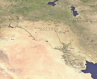
- Mesopotamia
- Lower Mesopotamia
- Upper Mesopotamia
- Iran
- Anatolia (Turkey)
- Levant
- Arabian Peninsula
- Cyprus
- Nubia
- Horn of Africa
- Egypt
- See also
- References
- External links
The largest cities of the Bronze Age Near East housed several tens of thousands of people. Memphis in the Early Bronze Age, with some 30,000 inhabitants, was the largest city of the time by far. Ebla is estimated to have had a population of 40,000 inhabitants in the Intermediate Bronze age. [1] Ur in the Middle Bronze Age is estimated to have had some 65,000 inhabitants; Babylon in the Late Bronze Age similarly had a population of some 50,000–60,000. Niniveh had some 20,000–30,000, reaching 100,000 only in the Iron Age (around 700 BC).
In Akkadian and Hittite orthography, URU𒌷 became a determinative sign denoting a city, or combined with KUR 𒆳 "land" the kingdom or territory controlled by a city, e.g. 𒈗𒆳𒌷𒄩𒀜𒌅𒊭 LUGAL KUR URUHa-ad-tu-sha "the king of the country of (the city of) Ḫattuša". The KI𒆠 determinative is used following place names (toponyms) in both Sumerian and Akkadian. [2] [3]