Tell Shemshara

Last updated
Tell Shemshara
Shusharra
Iraq adm location map.svg
Archaeological site icon (red).svg
Shown within Iraq
Alternative nameTell Shimshara
Location Iraq
Region Sulaymaniyah Governorate
Coordinates 36°12′03″N44°56′18″E / 36.20083°N 44.93833°E / 36.20083; 44.93833
Type tell
Length270 m (890 ft) (lower mound)
Width60 m (200 ft) (main mound)
Height19 m (62 ft) (main mound), 6 m (20 ft) (lower mound)
History
Periods Hassuna, Middle Bronze Age, Islamic
Site notes
Excavation dates1957–1959, 2012
ArchaeologistsJ. Eidem, H. Ingholt, J. Læssøe, A. al-Qadir at-Tekrîti
Conditionperiodically flooded by Lake Dukan

Tell Shemshara (ancient Shusharra) (also Tell Shimshara) is an archaeological site located along the Little Zab in Sulaymaniyah Governorate, northeastern Iraq. The site was inundated by Lake Dukan until recently.

Contents

The site was occupied, although not continuously, from the Hassuna period (early sixth millennium BCE) until the 14th century CE. A small archive recovered from the Middle Bronze Age layers (early second millennium BCE) revealed that, at least in that period, the site was called Shusharra and was the capital of a small, semi-independent Turukkean polity called māt Utêm or "land of the gatekeeper" ruled by a man called Kuwari acting as governor under a larger Hurrian state. [1]

Archaeology

The site was first recorded in 1955 during an archaeological survey of the Ranya Plain, which was to be flooded by the reservoir of the planned Dukan Dam. [2] In 1957, a Danish team of archaeologists started a rescue excavation because the site would be flooded by Lake Dukan once the Dukan Dam would be finished. [3] The Danish excavation was directed by Professors Harold Ingholt, who also excavated the citadel mound of Hama, and Jørgen Læssøe. [4] It was funded by the Carlsberg Foundation and the Danish Government Foundation for the Promotion of Research. [5] About 146 cuneiform tablets were found, mostly letters and most in one location, believed to have been stored in a pot on excavation level V. [6] The excavations were continued in 1958 and 1959 by Iraqi archaeologists of the State Board of Antiquities and Heritage (SBAH) under the direction of Abd al-Qadir at-Tekrîti. [4] The work was never published but about 103 cuneiform tablets (45 well preserved and the rest in poor condition) tablets were found during the 1958 excavations in rooms near the findspot of the earlier tablets but in loose soil above excavation level V. They are all administrative texts. [7] The excavations have revealed that the site was occupied at least from the Hassuna period onward and the latest occupation phase dates to the 12th–14th centuries CE. The objects found during the Danish excavation were divided between the National Museum of Iraq and the National Museum of Denmark. [8] So far, the prehistoric material of the Hassuna layers and the majority of the archives from the second millennium BCE have been published. [9] [10] [11]

In 2012, teams of the Netherlands Institute for the Near East and the Central Zagros Archaeological Project (CZAP) conducted new investigations at the site, as part of a larger archaeological project focussing on the entire Ranya Plain. [12] [13] [14] High water prevented work in 2016-2017 but in October 2018 low levels allowed a short season of work. [15] [16]

The site and its environment

Tell Shemshara sits along the Little Zab, a tributary of the Tigris. Its strategic location in the northeastern corner of the Ranya Plain in the Zagros Mountains gave Shemshara control over travelling routes in all directions, particularly toward the north and east. Shemshara is a tell, or settlement mound, that can be divided in two parts; a high main mound and an elongated lower mound to the south. The main mound is about 75 meters wide at the bottom and about 25 meters wide at the top, whereas the lower town is 265 metres (869 ft) long and 13 metres (43 ft) high. [8] Shemshara is now partially submerged under Lake Dukan. [4] It has lost 164,000 cubic meters of volume to erosion since 1957 and at high water levels becomes an island.

Occupation history

The excavations at the main mound revealed 16 occupation layers, ranging in date from the Hassuna period (early sixth millennium BCE) to the 14th century CE. A single radiocarbon sample from the basal level of the site, 3m below level 16, provided a date of 7322–7180 BC (IntCal13). [17]

Hassuna Period

Layers 16–9 dated to the Hassuna period. This occupation was characterized by rows of stones that are interpreted by the excavators as foundations for mudbrick walls, a pebble floor and a clay basin in the final occupation layer. [18] Pottery, which has only been found in abundance in layers 13–9, shows stylistic links with that of Hassuna and Tell es-Sawwan. [19] Obsidian was the preferred material for stone tools, with flint making up only 15 percent of the total assemblage. Whereas the flint was procured locally, the obsidian was obtained from two sources in eastern Turkey – one as yet unidentified, the other one being the volcanic Nemrut Dağ more than 300 kilometres (190 mi) away from Shemshara. [20] A unique piece in this assemblage is a dagger of over 35.5 centimetres (14.0 in) in length, broken in four pieces due to a fire. [21] Other artifacts that have been found at the site include stone bowls, bracelets and quern-stones and small objects made of bone. [22]

Uruk and Jemdet Nasr Period

Whereas the main mound seems to have been abandoned after the Hassuna occupation, scarce archaeological material from the Uruk (fourth millennium BCE) and Jemdet Nasr periods (early third millennium BCE) has been found on the lower town. [23] [24]

Middle Bronze Age

Both the main mound and the lower extension were re-occupied during the Middle Bronze Age (early second millennium BCE). Layers 8–4 on the main mound can be assigned to this period, mainly Hurrian in nature. [25] [8] The excavations found a number of graves with bronze weapons on the main mound, as well as a mudbrick platform. In the lower town, a small part of a palace was excavated, and in three of its rooms a small archive of clay tablets was found. [6] [7] The palace was destroyed by fire, and through analysis of the archive it has been proposed that this happened in year 30 of the reign of Shamshi-Adad I of Ekallatum in the first quarter of the 18th century BCE. [4]

The archive consisted of 146 clay tablets or fragments thereof, found in two groups, of which a small part dealt with the administration of the town, whereas the majority consisted of letters written to a certain Kuwari. Some fragments were part of the clay envelopes in which these letters were sent. [26] The texts were written in Akkadian. These texts revealed that during this period the site was called Shusharra (also known from texts at Mari, that it was the capital of a polity called māt Utêm or "land of the gatekeeper" and that it was ruled by a man named Kuwari. [27] Chronologically, the archive can be divided in two parts, one covering the period during which Shemshara was the capital of a small semi-independent kingdom, and one covering the period after Kuwari decided to become a vassal of Shamshi-Adad (who then established a garrison at Shemshara), who at that time had already conquered Mari and Shubat-Enlil and was now campaigning in the Zagros Mountains. Together, these two periods do not last longer than 3 years. [28] The letters in the Shemshara archive show that during this period, Kuwari had to deal with Turukkean refugees coming from the east and fleeing a war with Guteans (led by their leader Endusse); events which are also mentioned in the much larger archives found in Mari on the Syrian Euphrates. [29]

Islamic Period

Layers 1-3 were Islamic.

See also

Notes

  1. M. T. Larson, "The Shemshara Archives", Sumer, vol. 42, no. 1-2, pp. 36-39, 1983
  2. Soof, Behnam Abu., "Mounds in the Rania Plain and Excavations at Tell Basmusian (1956)", Sumer, vol. 26, pp.65-104, 1970
  3. Ingholt, H, "The Danish Dokan Expedition", Sumer, vol. 13, no. 1-2, pp. 214-215, 1957
  4. 1 2 3 4 Eidem 1992 , pp. 11–13
  5. Mortensen 1970 , p. 9
  6. 1 2 Laessøe, J., "An Old-Babylonian Archive Discovered at Tell Shemshara", Sumer, vol. 13, no. 1-2, pp. 216-218, 1957
  7. 1 2 Laessøe, J., "The Second Shemshara Archive", Sumer vol. 16, no. 1-2, pp. 12-19, 1960
  8. 1 2 3 Mortensen 1970 , pp. 11–14
  9. Mortensen 1970
  10. Eidem 1992
  11. Eidem & Læssøe 2001
  12. Eidem 2012
  13. Shimshara n.d.
  14. Jesper Eidem, "Back to Shemshara. NINO Excavations 2012-2015", in Zagros Studies PIHANS Volume 130 Proceedings of the NINO Jubilee Conference and Other Research on the Zagros Region, 2020 ISBN   978-90-429-4055-0
  15. Jesper Eidem, Matteo Merlino, and Emanuele Mariotti, Tell Shemshara 2018: Emerging and Floating Evidence, Ash-Sharq, 2019
  16. Matthews, Wendy, et al., "Excavations and Contextual Analsyes: Shimshara", The Early Neolithic of the Eastern Fertile Crescent: Excavations at Bestansur and Shimshara, Iraqi Kurdistan, edited by Wendy Matthews et al., Oxbow Books, pp. 177–86, 2020
  17. Flohr, Pascal, et al., "Radiocarbon dating of Bestansur and Shimshara", The Early Neolithic of the Eastern Fertile Crescent: Excavations at Bestansur and Shimshara, Iraqi Kurdistan, edited by Roger Matthews et al., Oxbow Books, pp. 187–96, 2020
  18. Mortensen 1970 , pp. 17–23
  19. Mortensen 1970 , p. 62
  20. Mortensen 1970 , p. 27
  21. Mortensen 1970 , pp. 33–35
  22. Mortensen 1970 , pp. 47ff., 58ff.
  23. Al-Soof 1964
  24. Al-Soof 1968 , p. 82
  25. Peder Mortensen, "On the Chronology of Early Village-Farming Communities in Northern Iraq", Sumer, vol. 18, pp. 76-80, 1962
  26. Eidem & Læssøe 2001 , p. 14
  27. Eidem 1992 , p. 17
  28. Eidem 1992 , p. 16
  29. Eidem 1992 , p. 18

Related Research Articles

<span class="mw-page-title-main">Zagros Mountains</span> Mountain range in Western Asia

The Zagros Mountains are a long mountain range in Iran, northern Iraq, and southeastern Turkey. This mountain range has a total length of 1,600 km (990 mi). The Zagros mountain range begins in northwestern Iran and roughly follows Iran's western border while covering much of southeastern Turkey and northeastern Iraq. From this border region, the range continues to the southeast under also the waters of the Persian Gulf. It spans the southern parts of the Armenian highland, the whole length of the western and southwestern Iranian plateau, ending at the Strait of Hormuz. The highest point is Mount Dena, at 4,409 metres (14,465 ft).

<span class="mw-page-title-main">Tell Hassuna</span> Archaeological type site

Tell Hassuna is a tell, or settlement mound, in the Nineveh Province (Iraq), about 35km south-west of Nineveh. It is the type site for the Hassuna culture.

<span class="mw-page-title-main">Tell Leilan</span> Archaeological site in Syria

Tell Leilan is an archaeological site situated near the Wadi Jarrah in the Khabur River basin in Al-Hasakah Governorate, northeastern Syria. The site has been occupied since the 5th millennium BC. During the late third millennium, the site was known as Shekhna. During that time it was under control of the Akkadian Empire and was used as an administrative center. Around 1800 BC, the site was renamed "Shubat-Enlil" by the king Shamshi-Adad I, and it became his residential capital. Shubat-Enlil was abandoned around 1700 BC.

<span class="mw-page-title-main">Lullubi</span> 2300–675 BC Ancient Near Eastern group of tribes

Lullubi,Lulubi, more commonly known as Lullu, were a group of tribes during the 3rd millennium BC, from a region known as Lulubum, now the Sharazor plain of the Zagros Mountains of modern-day Sulaymaniyah Governorate, Iraq. Lullubi was neighbour and sometimes ally with the Simurrum kingdom. Frayne (1990) identified their city Lulubuna or Luluban with the region's modern town of Halabja.

<span class="mw-page-title-main">Tell Brak</span> Archaeological site in Syria

Tell Brak was an ancient city in Syria; its remains constitute a tell located in the Upper Khabur region, near the modern village of Tell Brak, 50 kilometers north-east of Al-Hasaka city, Al-Hasakah Governorate. The city's original name is unknown. During the second half of the third millennium BC, the city was known as Nagar and later on, Nawar.

<span class="mw-page-title-main">Little Zab</span> River in Iran, Iraq

The Little Zab or Lower Zab is a river that originates in Iran and joins the Tigris just south of Al Zab in the Kurdistan region of Iraq. It is approximately 400 kilometres (250 mi) long and drains an area of about 22,000 square kilometres (8,500 sq mi). The river is fed by rainfall and snowmelt, resulting in a peak discharge in spring and low water in summer and early fall. Two dams have been built on the Little Zab, regulating the river flow, providing water for irrigation and generating hydroelectricity. The Zagros Mountains have been occupied since at least the Lower Palaeolithic, but the earliest archaeological site in the Little Zab basin, Barda Balka, dates to the Middle Palaeolithic. Human occupation of the Little Zab basin has been attested for every period since then.

<span class="mw-page-title-main">Lake Dukan</span> Reservoir in Sulaymaniyah Governorate

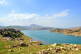
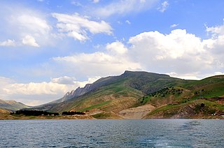
Lake Dukan is a lake in Kurdistan Region Iraq. It is located close to the city of Ranya, and is a reservoir on the Little Zab created by the construction of the Dukan Dam. The Dukan Dam was built between 1954 and 1959 as a multi-purpose dam to provide water storage, irrigation and hydroelectricity. Prior to the flooding of Lake Dukan, the area has been subjected to archaeological research to investigate as many archaeological sites as possible. An archaeological survey in the Ranya Plain documented some 40 archaeological sites with evidence for occupation ranging from the sixth millennium BCE up to the present. Five of these sites were then excavated: Tell Bazmusian, ed-Dem, Kamarian, Qarashina and Tell Shemshara. The excavations at Tell Bazmusian revealed a temple dating to the second millennium BCE. At Tell Shemshara, an early-sixth millennium BCE village was excavated, as well as an early-second millennium BCE palace with a small archive of clay tablets. The inhabitants of some 50 villages in the flooded area, around 1,000–1,200 families, were resettled to the west of the lake.

<span class="mw-page-title-main">Carlsberg Foundation</span>

Carlsberg Foundation is a not-for-profit organization that was founded by J. C. Jacobsen in 1876, by allocating some of his shares in the Carlsberg Brewery to fund and operate the Carlsberg Laboratory and the Museum of National History at Frederiksborg Palace. The foundation has since expanded to fund scientific research, and via the Tuborg Foundation to fund social works. As of 2011 it owned 30.3% of the shares in Carlsberg Group and controlled 74.2% of the voting power.

<span class="mw-page-title-main">Samarra culture</span> Late Neolithic archaeological culture of Mesopotamia

The Samarra culture is a Late Neolithic archaeological culture of northern Mesopotamia, roughly dated to between 5500 and 4800 BCE. It partially overlaps with Hassuna and early Ubaid. Samarran material culture was first recognized during excavations by German Archaeologist Ernst Herzfeld at the site of Samarra. Other sites where Samarran material has been found include Tell Shemshara, Tell es-Sawwan, and Yarim Tepe.

Tell al-Rimah is a tell, or archaeological settlement mound, in Nineveh Province (Iraq) roughly 80 kilometres (50 mi) west of Mosul and ancient Nineveh in the Sinjar region. It lies 15 kilometers south of the site of Tal Afar. Its ancient name may have been either Karana or Qattara, though the later name is now less favored.

<span class="mw-page-title-main">Dukan Dam</span> Dam in Sulaymaniyah Governorate, Kurdistan Region

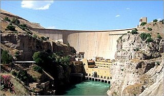
The Dukan Dam is a multi-purpose concrete arch dam in As Sulaymaniyah Governorate, Kurdistan Region of Iraq. It impounds the Little Zab, thereby creating Lake Dukan. The Dukan Dam was built between 1954 and 1959 whereas its power station became fully operational in 1979. The dam is 360 metres (1,180 ft) long and 116.5 metres (382 ft) high and its hydroelectric power station has a maximum capacity of 400 MW.

Tell es-Sawwan is an important Samarran period archaeological site in Saladin Province, Iraq. It is located 110 kilometres (68 mi) north of Baghdad, and south of Samarra. It lies on a 12 meter high cliff overlooking the Tigris River.

<span class="mw-page-title-main">Tell Bazmusian</span>

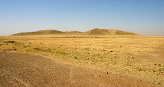
Tell Bazmusian is an archaeological site on the right bank of the Little Zab in the Ranya Plain. The site was excavated between 1956 and 1958 by Iraqi archaeologists as part of a salvage operation to document cultural remains that would be flooded by Lake Dukan, the reservoir created by the Dukan Dam which was being built at that time. Apart from Tell Bazmusian, four other sites were excavated during this operation: ed-Dem, Kamarian, Qarashina and Tell Shemshara. Bazmusian is a tell, or settlement mound, with a circumference of 1,500 metres (4,900 ft) and a height of 23 metres (75 ft). Together with Tell Shemshara, it is one of the largest archaeological sites in the Ranya Plain. When the excavations started, the southeast flank of the mound was occupied by a village that was only established at the beginning of the 20th century. The site is now submerged under Lake Dukan.

<span class="mw-page-title-main">National Museum of Denmark</span> National gallery in Copenhagen, Denmark

The National Museum of Denmark (Nationalmuseet) in Copenhagen is Denmark's largest museum of cultural history, comprising the histories of Danish and foreign cultures, alike. The museum's main building is located a short distance from Strøget at the center of Copenhagen. It contains exhibits from around the world, from Greenland to South America. Additionally, the museum sponsors SILA - The Greenland Research Center at the National Museum of Denmark to further archaeological and anthropological research in Greenland.

The Turukkaeans were a Bronze and Iron Age people of Mesopotamia and the Zagros Mountains, in South West Asia. Their endonym has sometimes been reconstructed as Tukri.

<span class="mw-page-title-main">Simurrum</span>

Simurrum was an important city state of the Mesopotamian area from around 2000 BCE to 1500 BCE, during the period of the Akkadian Empire down to Ur III. The Simurrum Kingdom disappears from records after the Old Babylonian period. It is thought that in Old Babylonian times its name was Zabban, a notable cult center of Adad. It was neighbor and sometimes ally with the Lullubi kingdom.

<span class="mw-page-title-main">Bestansur</span> Neolithic site in Iraq

Bestansur is a Neolithic tell, or archaeological settlement mound, located in Sulaimaniyah province, Kurdistan Regional Government, Iraq in the western Zagros foothills. The site is located on the edge of the Shahrizor Plain, 30 km to the south-east of Sulaimaniyah. It is on the UNESCO World Heritage Tentative List.

<span class="mw-page-title-main">Jørgen Læssøe</span> Danish Assyriologist

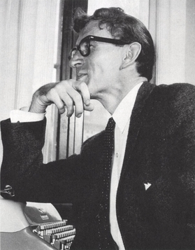
Jørgen Læssøe was a Danish Assyriologist and professor at the University of Copenhagen. He directed the Danish excavations at Tell Shemshara, uncovering an Old Assyrian palace complex and a substantial cache of cuneiform texts known as the Shemshara Archives, which became his main object of study. He also worked on inscriptions from Max Mallowan's excavations at Nimrud, served as the field director of the Scandinavian Joint Expedition to Sudanese Nubia, and published a number of popular history books on Assyriology in Danish, including his magnum opus, The People of Ancient Assyria (1963).

<span class="mw-page-title-main">Tell Kunara</span> ِAkkadian-Lullubian archaeological site in Iraq

Tell Kunara is an ancient Near East archaeological site about 5 kilometres (3.1 mi) southwest of Sulaymaniyah in the Kurdistan region of Iraq. It lies on the Tanjaro River. The site was occupied from the Chalcolithic period to the early second millennium BC.

Kurd Qaburstan, is an ancient Near East archaeological site in the Erbil Governorate, in the Kurdistan Region of Iraq, 22 kilometers southwest of Erbil. It is considered one of the most important archaeological sites in the area. It lies halfway between the Upper and Lower Zab rivers. The modern village of Yedi Kizlar covers to southeastern part of the lower town. The site dates back to the late 3rd millennium BC but was primarily occupied during the first half of the 2nd millennium, in the Old Babylonian and Mitanni periods. It has been suggested as the site of the ancient city of Qabra. Nearby promising excavations are at Tell Baqrta and Qasr Shemamok (Kilizi).

References

Further reading