Description
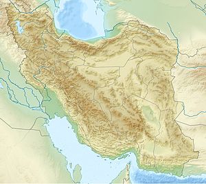
Kul Tepe is a multi-period tell about 6 ha in extent, and 19 m high. It is located 967 m above sea level.
About 50km away is the related site of Kultepe, Azerbaijan. [1] In Iran downstream the Araxes river, two additional sites from the same period have also recently been excavated, Kohne Pasgah and Kohne Tepesi. [2]
At Kul Tepe Jolfa, material was found from the Dalma culture period (5000–4500 BC), and then following to the Pisdeli period, Chaff-Faced Ware horizons, and Kura–Araxes I and II periods. This is the Early Trans-Caucasian or Kura–Araxes culture, which spread through the Caucasus and the Urmia Basin around 3500 BC. [3]
Later, the Middle and Late Bronze Age (Urmia ware), and Iron and Urartian/Achaemenid periods are also attested.
Dava Goz is another related site in the area that was recently excavated. It is located about 5km north of Dizaj Diz, Iran. This is a small and very old site that begins in the Late Neolithic/Transitional Chalcolithic period, similar to Hajji Firuz Tepe; it may have started c. 6000 BC. [1]
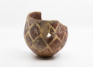
Chaff-faced and chaff-tempered pottery with combed surfaces is a typical Late Chalcolithic pottery of Southern Azerbaijan. It is found in Kultepe, Azerbaijan and elsewhere in the Nakhichevan region, and in the Lake Urmia region of north-western Iran. But it is also common in other areas of the Middle East, such as in northern Syria and Mesopotamia. It is very well attested at Amuq.
According to Akbar Abedi,
"To sum up, the emerging picture suggests that the Chaff-Faced Ware system, whose focus was the highlands, was progressively challenged during the 4th millennium in the north as in the south, by the Kura––Araxes and Uruk expansions, respectively. After a period of coexistence with both, the Chaff-Faced Ware culture was superseded in the highlands by the Kura-Araxes phenomenon, whose driving forces probably had some decisive advantage over its regional neighbours: judging by the importance of metallurgy and mining activities in the Kura-Araxes world, this advantage could have been technological." [1]

The Kura–Araxes culture was an archaeological culture that existed from about 4000 BC until about 2000 BC, which has traditionally been regarded as the date of its end; in some locations it may have disappeared as early as 2600 or 2700 BC. The earliest evidence for this culture is found on the Ararat plain; it spread north in the Caucasus by 3000 BC.

Godin Tepe is an archaeological site in western Iran, located in the valley of Kangavar in Kermanshah province. The importance of the site may have been due to its role as a trading outpost in the early Mesopotamian trade networks.
Aratashen is a town in the Armavir Province of Armenia. It is located on the Ararat Plain.
Xələc is a village and municipality in the Sharur District of Nakhchivan, Azerbaijan. It is located near the Khalaj Mount, eight kilometres (5.0 mi) north-west of the district center, on the bank of the Aras River. Its population is mainly busy with farming. There are secondary school, kindergarten, library, club and a medical center in the village. It has a population of 1,268.
Böyük Kəsik is a village and municipality in the Aghstafa District of Azerbaijan. It has a population of 1,791.

Kültəpə is a settlement dating from the Neolithic, a village and municipality in the Babek District of Nakhchivan, Azerbaijan. It has a population of 1,859.
Ərəbyengicə is a village and municipality in the Sharur District of Nakhchivan Autonomous Republic, Azerbaijan. It is located 12 km in the south from the district center, on the left bank of the Arpachay River. Its population is busy with farming and animal husbandry. There are secondary school, club and a medical center in the village. It has a population of 894.
Dizə is a village and municipality in the Sharur District of Nakhchivan Autonomous Republic, Azerbaijan. It is located on the left bank of the river Arpachay (Arpa), on the Sharur plain. On the other side of the river is the village of Oğlanqala.
Hadishahr, also Romanized as Hādīshahr and Hādī Shahr; also known as Gargar and Alamdar, is a city in the Central District of Jolfa County, East Azerbaijan province, Iran.

The Leyla-Tepe culture of the South Caucasus belongs to the Chalcolithic era. It got its name from the site in the Agdam District of modern-day Azerbaijan. Its settlements were distributed on the southern slopes of Central Caucasus, from 4350 until 4000 B.C.

Janan Lu, also Romanized as Jānān Lū and Jānānlū, is a village in, and the capital of, Minjavan-e Sharqi Rural District of Minjavan District, Khoda Afarin County, East Azerbaijan province, Iran.

Alikomektepe is an ancient settlement located in Jalilabad District (Azerbaijan), in the Mughan plain, belonging to the Chalcolithic period, dating to c. 5000 BC. Early levels belonged to the Shulaveri–Shomu culture. It covers an area of over 1 hectare.
Bronze Age in Azerbaijan began in the second half of the 4th millennium BC and ended in the second half of the 2nd millennium BC, while the Iron Age commenced in approximately 7-6th centuries BC. The Bronze Age in the territory of today's Azerbaijan is divided into the early Bronze Age, the middle Bronze Age and the late Bronze Age. Bronze Age was studied in Nakhchivan, Ganja, Dashkasan, Mingachevir, Gobustan, Qazakh and Karabakh.
Dalma culture was a prehistoric archaeological culture of north-western Iran dating to early fifth millennium B.C. Later, it spread into the central Zagros region and elsewhere in adjacent areas. Its widespread ceramic remains were excavated in central and northern valleys of the Zagros Mountains in north-western Iran. Dalma assemblages were initially discovered by the excavations carried out at Dalma Tepe and Hasanlu Tepe in south-western parts of Lake Urmia, in the valley of Solduz.
Uçan ağıl is an archaeological site north of Sirab village in Babek District of Nakhchivan Autonomous Republic, Azerbaijan. It is located at the altitude of 1200 m a.s.l. in the Sirab piedmonts, in the upper reaches of Sirab Suyu river along with other sites from the same period, Sorsu, and Zirinclik. It is dated at ca 4850-4350 BC time span, but was also occupied in the 3rd millennium BC. Uçan Ağıl was likely used by mobile pastoralists on a seasonal basis. They mostly pastured herds of goats.
Bülövaqaya settlement is an archeological site located on the left bank of the Sarisu river, west of Göynük village of Babek district.
Ovçular Tepesi is an ancient settlement located at the northern end of Dizə, Sharur village in Sharur District of Azerbaijan, on the left bank of Arpa (river). It dates back to the fifth millennium BC, and continued to the third millenniums BC.

Dalma Tepe is an archaeological site about 2km northeast of Naqadeh, Naqadeh County, in the Iranian province of West Azerbaijan. It is the type site of Dalma culture, a prehistoric culture of north-western Iran from the fifth millennium B.C.

Godedzor is a prehistorical archaeological site located about 1,5 kilometres west of the village of Angeghakot in the Syunik Province of Armenia. The settlement of Nerkin Godedzor is in the Vorotan river gorge, at the altitude of 1800 meters. Some petroglyphs are also found close by.
Nakhchivan Tepe (Naxçıvantəpə) is a Chalcolithic settlement in Nakhchivan, Azerbaijan. It is located in Nakhchivan (city) and is dated to the first half of the 5th millennium BC. It is on the right bank of the Nakhchivançay river at the altitude of 850m.