Khabur (Euphrates)

Last updated
Khabur
Khabur,SheikhHamad.jpg
Khabur south of Al-Hasakah
Khabur River in Syria 2004 CIA map.jpg
Native name
Location
Country Syria, Turkey
City Ra's al-'Ayn, Al-Hasakah, Busayrah
Physical characteristics
Source Ras al-Ayn
  elevation350 m (1,150 ft)
Mouth Euphrates
  coordinates
35°8′33″N40°25′51″E / 35.14250°N 40.43083°E / 35.14250; 40.43083
Length486 km (302 mi)
Basin size37,081 km2 (14,317 sq mi)
Discharge 
  average45 m3/s (1,600 cu ft/s)
  minimum2 m3/s (71 cu ft/s)
  maximum57 m3/s (2,000 cu ft/s)
[1] [2]

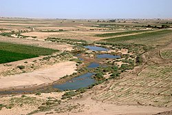
The Khabur River is the largest perennial tributary to the Euphrates in Syria. Although the Khabur originates in Turkey, the karstic springs around Ras al-Ayn are the river's main source of water. Several important wadis join the Khabur north of Al-Hasakah, together creating what is known as the Khabur Triangle, or Upper Khabur area. From north to south, annual rainfall in the Khabur basin decreases from over 400 mm to less than 200 mm. This has made the river a vital water source for agriculture throughout history. The Khabur joins the Euphrates near the town of Busayrah.

Contents

Geography

The course of the Khabur can be divided in two distinct zones: the Upper Khabur area or Khabur Triangle north of Al-Hasakah, and the Middle and Lower Khabur between Al-Hasakah and Busayrah.

Tributaries

The tributaries to the Khabur are listed from east to west. Most of these wadis only carry water for part of the year.

History

The river was well noted by ancient writers, with various names used by various writers: Ptolemy and Pliny the Elder called it the Chaboras (Ancient Greek : Χαβώρας), [3] Procopius called it the Chabura, [4] Strabo, Zosimus, and Ammianus Marcellinus called it the Aborrhas (Ἀβόρρας), [5] and Isidore of Charax called it the Aburas (Ἀβούρας). [6] It was described as a large river of Mesopotamia which rose in Mons Masius, about 40 miles (64 km) from Nisibis, and flowed into the Euphrates at Circesium (Kerkesiah). Procopius speaks of it as a river of importance, and Ammianus states that Julian the Apostate crossed it "per navalem Aborae pontem". Strabo describes it as near the town of Anthemusias.

The river is fed by several smaller streams, the names of which are mentioned in the later classical writers. These are, the Scirtus (Procop. de Aedif. 2.7), the Cordes (Procop. de Aedif. 2.2), and the Mygdonius (Julian. Or. i.).

Ptolemy (5.18.6) mentions a town called Chabora (Χαβώρα), on the Euphrates, which he places near Nicephorion, and which probably derives its name from the river, and Theophylact Simocatta mentions Ἀβορέων φρούριον, which is, as certainly, the same place. [7]

Since the 1930s, numerous archaeological excavations and surveys have been carried out in the Khabur Valley, indicating that the region has been occupied since the Lower Palaeolithic period. [8] Important sites that have been excavated include Tell Halaf, Tell Brak, Tell Leilan, Tell Mashnaqa, Tell Mozan and Tell Barri. The region has given its name to a distinctive painted ware found in northern Mesopotamia and Syria in the early 2nd millennium BCE, called Khabur ware. The region of the Khabur River is also associated with the rise of the Kingdom of the Mitanni that flourished c. 1500–1300 BC.

The Khabur River is mentioned in the Hebrew Bible: "Tiglath-Pileser ... took the Reubenites, the Gadites and the half tribe of Manasseh into exile. He took them to Halah, Habor (Khabur), Hara and the River Gozan, where they are to this day". [9] The identification of the Khabur with the Habor is not contested.

The ancient city of Corsote, visited by Cyrus the Younger on his ill-fated expedition against the Persians as told by Xenophon, was located at the confluence of the Khabur River, known by them as the 'Mascas', and the Euphrates according to Robin Waterfield. [10] Other authors have been circumspect upon the precise location of Corsote due to the changing names and courses of the rivers since that time. [11]

The Khabur river was sometimes identified with the Chebar or Kebar, the location of Tel Abib and setting of several important scenes of the Book of Ezekiel. However, recent scholarship identifies the Chebar as the ka-ba-ru waterway mentioned among the 5th century BCE Murushu archives from Nippur, close to Nippur and the Shatt el-Nil, a silted up canal toward the east of Babylon. [12]

Modern Khabur River Valley

Assyrian Church in Khabur River Valley. Assyrian church in Al-Khabur.jpg
Assyrian Church in Khabur River Valley.

The Khabur River Project, begun in the 1960s, involved the construction of a series of dams and canals. Three dams were built in the Khabur Basin as part of a large irrigation scheme that also includes the Tabqa Dam on the Euphrates. The section of the Khabur River within Tell Tamer Subdistrict are home to a self-governing Assyrian enclave. Two dams, Hasakah West and Hasakah East, have been constructed on tributaries to the Khabur between Ra's al-'Ayn and Al-Hasakah. The capacity of the reservoir of Hasakah West is 0.09 km3, and is also the southeastern end of the Assyrian enclave. The capacity of Hasakah East is 0.2 km3. A third dam, Hassakeh South, was constructed on the Khabur 25 km south of Al-Hasakah. The reservoir of this dam has a capacity of 0.7 km3. [13] The Khabur Valley, which now has about four million acres (16,000 km²) of farmland, is Syria's main wheat-cultivation area. The northeastern part is also the center for Syria's oil production.

Related Research Articles

<span class="mw-page-title-main">Euphrates</span> River in Turkey, Iraq, and Syria

The Euphrates is the longest and one of the most historically important rivers of Western Asia. Together with the Tigris, it is one of the two defining rivers of Mesopotamia. Originating in Turkey, the Euphrates flows through Syria and Iraq to join the Tigris in the Shatt al-Arab, which empties into the Persian Gulf.

<span class="mw-page-title-main">Geography of Iraq</span> Geographic features of Iraq

The geography of Iraq is diverse and falls into five main regions: the desert, Upper Mesopotamia, the northern highlands of Iraq, Lower Mesopotamia, and the alluvial plain extending from around Tikrit to the Persian Gulf.

<span class="mw-page-title-main">Geography of Syria</span> Geographical features of Syria

Syria is located in West Asia, north of the Arabian Peninsula, at the eastern end of the Mediterranean Sea. It is bordered by Turkey to the north, Lebanon and Israel to the west and southwest, Iraq to the east, and Jordan to the south. It consists of mountain ranges in the west and a steep area inland. In the east is the Syrian Desert and in the south is the Jabal al-Druze Range. The former is bisected by the Euphrates valley. A dam built in 1973 on the Euphrates created a reservoir named Lake Assad, the largest lake in Syria. The highest point in Syria is Mount Hermon on the Lebanese border at 2,814 metres or 9,232 feet. Between the humid Mediterranean coast and the arid desert regions lies a semiarid steep zone extending across three-quarters of the country, which receives hot, dry winds blowing across the desert. Syria is extensively depleted, with 28 percent of the land arable, 4 percent dedicated to permanent crops, 46 percent utilized as meadows and pastures, and only 3 percent forest and woodland.

<span class="mw-page-title-main">Geography of Mesopotamia</span>

The geography of Mesopotamia, encompassing its ethnology and history, centered on the two great rivers, the Tigris and Euphrates. While the southern is flat and marshy, the near approach of the two rivers to one another, at a spot where the undulating plateau of the north sinks suddenly into the Babylonian alluvium, tends to separate them still more completely. In the earliest recorded times, the northern portion was included in Mesopotamia; it was marked off as Assyria after the rise of the Assyrian monarchy. Apart from Assur, the original capital of Assyria, the chief cities of the country, Nineveh, Kalaḫ and Arbela, were all on the east bank of the Tigris. The reason was its abundant supply of water, whereas the great plain on the western side had to depend on streams flowing into the Euphrates.

<span class="mw-page-title-main">Balikh River</span> River in Turkey, Syria

The Balikh River is a perennial river that originates in the spring of Ain al-Arous near Tell Abyad in the Eastern Mediterranean conifer-sclerophyllous-broadleaf forests ecoregion. It flows due south and joins the Euphrates at the modern city of Raqqa. The Balikh is the second largest tributary to the Euphrates in Syria, after the Khabur River. It is an important source of water and large sections have recently been subjected to canalization.

<span class="mw-page-title-main">Assyrians in Syria</span> Ethnic group

Assyrians in Syria also known as Syriacs are an ethnic and linguistic minority that are indigenous to Upper Mesopotamia, the north-eastern half of Syria. Syrian-Assyrians are people of Assyrian descent living in Syria, and those in the Assyrian diaspora who are of Syrian-Assyrian heritage.

Tell Tamer also known as Tal Tamr or Tal Tamir, is a town in western al-Hasakah Governorate, northeastern Syria. It is the administrative center of the Tell Tamer Subdistrict consisting of 13 municipalities.

<span class="mw-page-title-main">Al-Hasakah</span> City in al-Hasakah, Syria

Al-Hasakah is the capital city of the Al-Hasakah Governorate, in the northeastern corner of Syria. With a 2023 estimated population of 422,445 Al-Hasakah is predominantly populated by Arabs with large numbers of Kurds, Assyrians and a smaller number of Armenians. Al-Hasakah is 80 kilometres south of the city of Qamishli. The Khabur River, a tributary of the Euphrates River, flows west–east through the city. The Jaghjagh River flows into the Khabur from the north at Al-Hasakah. A portion of the city is a Syrian government-controlled enclave, comprising the city center and various government buildings, with the rest of the city controlled by the AANES.

<span class="mw-page-title-main">Ras al-Ayn</span> City in al-Hasakah, Syria

Ras al-Ayn, also spelled Ras al-Ain, is a city in al-Hasakah Governorate in northeastern Syria, on the Syria–Turkey border.

<span class="mw-page-title-main">Halabiye</span> Archaeological site in Deir ez-Zor, Syria

Halabiye is an archaeological site on the right bank of the Euphrates River in Deir ez-Zor Governorate, Syria. It was an ancient city and former bishopric known as Zenobia and a Latin Catholic titular see.

Rhesaina (Rhesaena) or Resina (Ῥέσινα) was a city in the late Roman province of Mesopotamia Secunda and a bishopric that was a suffragan of Dara.

Chabora was an ancient town on the Euphrates, near Nicephorion, that probably derives its name from the Chaboras river. Theophylact Simocatta mentions Ἀβορέων φρούριον, which is, according to William Smith, the same place.

<span class="mw-page-title-main">Deir ez-Zor Museum</span> Museum in Syria

The Deir ez-Zor Museum is a museum devoted to the archaeology and history of northeastern Syria, an area more commonly known as the Jezirah, or Upper Mesopotamia. The museum is located in Deir ez-Zor, the capital of Deir ez-Zor Governorate, Syria. It was founded in 1974 and housed in a gallery of a shopping mall. Between 1983 and 1996, it was located in an old law court built in 1930. In 1996, the museum moved to its current location in a building that had been especially designed for the museum. The exhibition halls cover an area of 1,600 square metres (17,000 sq ft) and are arranged around a courtyard. The construction of the new museum was a joint Syrian–German operation.

Tell Mashnaqa is an archaeological site located on the Khabur River, a tributary to the Euphrates, about 30 kilometres (19 mi) south of Al-Hasakah in northeastern Syria. The earliest occupation of the site dates to the Ubaid period, and was excavated by a Danish team from 1990–1995 in four seasons.

Tel Abib is an unidentified tell on the Kebar Canal, near Nippur in what is now Iraq. Tel Abib is mentioned by Ezekiel in Ezekiel 3:15:

Then I came to them of the captivity at Tel Abib, that lived by the river Chebar, and to where they lived; and I sat there overwhelmed among them seven days.

<span class="mw-page-title-main">Julian's Persian expedition</span> 363 war between the Roman and Sasanian empires

Julian's Persian expedition began in March 363 AD and was the final military campaign of the Roman emperor Julian. The Romans fought against the Sasanian Empire, ruled at the time by Shapur II.

<span class="mw-page-title-main">Diban</span> Town in Deir ez-Zor, Syria

Diban is a town in eastern Syria, administratively part of the Deir ez-Zor Governorate, located along the eastern bank of the Euphrates River, south of Deir ez-Zor, 17 kilometers south of al-Busayrah and 13 kilometers north of Al-Asharah. Nearby localities include Al Mayadin to the north and west, al-Hawayij to the northeast, Mahkan to the south west and al-Tayanah to the southeast. According to the Syria Central Bureau of Statistics, Diban had a population of 9,000 in the 2004 census. It is the administrative seat of a nahiyah ("subdistrict") which consists of ten localities with a total population of 65,079 in 2004.

<span class="mw-page-title-main">Tell Tuneinir</span>

Tell Tuneinir is an archaeological site in northeastern Syria. It dates to the early third millennium BC and shows signs of continuous habitation lasting until the beginning of the 15th century AD with epochs during the early Byzantine Empire, when it was known as the city of Thannuris (Thannourios), and during the Ayyubid period.

<span class="mw-page-title-main">Ḫabūrītum</span> Goddess of the river Khabur

Ḫabūrītum (dḫa-bu-ri-tum) was a goddess of the river Khabur worshiped in ancient Syria. She was incorporated into the Mesopotamian pantheon in the Ur III period. Her original cult center was most likely Sikani, which in the early third millennium was located in an area ruled by Hurrians. Not much is known about her character. In Mesopotamian texts she appears chiefly in association with other deities worshiped in Syria, such as Dagan and Ishara.

References

  1. Hole F; Zaitchik, BF (2007). "Policies, plans, practice, and prospects: irrigation in northeastern Syria". Land Degradation & Development. 18 (2): 133–152. doi:10.1002/ldr.772. S2CID   129117310.
  2. Burdon, DJ; Safadi, C (1963). "Ras-el-Ain: the great karstic spring of Mesopotamia. An hydrogeological study". Journal of Hydrology. 1 (1): 58–95. Bibcode:1963JHyd....1...58B. doi:10.1016/0022-1694(63)90033-7.
  3. Ptolemy, The Geography, 5.18.3; Pliny the Elder, Natural History, 30.3.
  4. Procopius, B.P., 2.5.
  5. Strabo, xvi; Zosimus, Historia Nova, 3.13; Ammianus Marcellinus, Rerum Gestarum, 14.3, 23.5.
  6. Isidore of Charax
  7. The History of Theophylact Simocatta, 4.10.
  8. Nishiaki, Y. (1992). "Preliminary results of the prehistoric survey in the Khabur Basin, Syria: 1990–91 seasons". Paléorient. 18 (1): 97–102. doi:10.3406/paleo.1992.4566 . Retrieved 7 July 2010.
  9. 1 Chronicles 5:26
  10. Waterfield, Robin (2006). Xenophon's retreat : Greece, Persia, and the end of the Golden Age. Cambridge, Massachusetts: Belknap Press of Harvard University Press. ISBN   9780674023567 . Retrieved 20 January 2017.
  11. Rennell, James (1816). Illustrations, chiefly geographical, of the history of the expedition of Cyrus, From Sardis to Babylonia and the retreat of the 10,000 Greeks. Bulmer. p. 101. Retrieved 21 January 2017.
  12. Thompson, Henry O. (1992). "Chebar", in ABD. Vol. 1. Doubleday. p. 893. ISBN   0-385-19351-3.
  13. Mutin, Georges (2003). "Le Tigre et l'Euphrate de la discorde". VertigO (in French). 4 (3): 1–10. doi: 10.4000/vertigo.3869 . Retrieved 18 December 2009.