
Ahab was the seventh king of Israel, the son and successor of King Omri and the husband of Jezebel of Sidon, according to the Hebrew Bible. The Hebrew Bible presents Ahab as a wicked king, particularly for condoning Jezebel's influence on religious policies and his principal role behind Naboth's arbitrary execution.

Shalmaneser III was king of the Neo-Assyrian Empire from the death of his father Ashurnasirpal II in 859 BC to his own death in 824 BC.
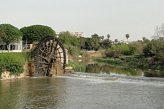
The Orontes or Asi is a river with a length of 571 kilometres (355 mi) in Western Asia that begins in Lebanon, flowing northwards through Syria before entering the Mediterranean Sea near Samandağ in Turkey.
The Battle of Qarqar was fought in 853 BC when the army of the Neo-Assyrian Empire led by Emperor Shalmaneser III encountered an allied army of eleven kings at Qarqar led by Hadadezer, called in Assyrian Adad-idir and possibly to be identified with King Benhadad II of Aram-Damascus; and Ahab, king of Israel. This battle, fought during the 854–846 BC Assyrian conquest of Aram, is notable for having a larger number of combatants than any previous battle, and for being the first instance in which some peoples enter recorded history, such as the Arabs. The battle is recorded on the Kurkh Monoliths. Using a different rescension of the Assyrian Eponym List would put the battle's date at 854 BC.
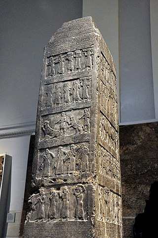
The Black Obelisk of Shalmaneser III is a black limestone Assyrian sculpture with many scenes in bas-relief and inscriptions. It comes from Nimrud, in northern Iraq, and commemorates the deeds of King Shalmaneser III. It is on display at the British Museum in London, and several other museums have cast replicas.
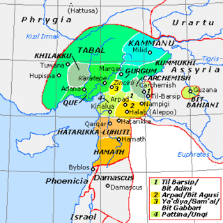
Carchemish, also spelled Karkemish was an important ancient capital in the northern part of the region of Syria. At times during its history the city was independent, but it was also part of the Mitanni, Hittite and Neo-Assyrian Empires. Today it is on the frontier between Turkey and Syria.
Gindibu was a king of the Qedarite Arabs.
Tushhan is a Kurdish village known as or by residents. It was an ancient city in Mesopotamia and was a provincial capital in the upper Tigris river valley, on the south bank and inhabited since the Mitanni period, and mainly during the Neo-Assyrian period during the Iron Age.
Tell Ta'yinat is a low-lying ancient tell on the east bank at the bend of the Orontes River where it flows through the Amuq valley, in the Hatay province of southeastern Turkey about 25 kilometers south east of Antakya, and lies near Tell Atchana, the site of the ancient city of Alalakh. Tell Ta'yinat has been proposed as the site of Alalaḫu, inhabited in late 3rd millennium BC, mentioned in Ebla's Palace G archive; and in later times as Kinalua, the capital city of an Iron Age Neo-Hittite kingdom.

Hadadezer ; also known as Adad-Idri, and possibly the same as Bar-Hadad II (Aram.) or Ben-Hadad II (Heb.), was the king of Aram Damascus between 865 and 842 BC.

Adad-nirari III was a King of Assyria from 811 to 783 BC. Note that this assumes that the longer version of the Assyrian Eponym List, which has an additional eponym for Adad-nirari III, is the correct one. For the shorter eponym list the ascension year would be 810 BC.

Samʼal, also Yaʼdiya or Zincirli Höyük, is an archaeological site located in the Anti-Taurus Mountains of modern Turkey's Gaziantep Province. It was founded at least as far back as the Early Bronze Age and thrived between 3000 and 2000 BC, and on the highest part of the upper mound was found a walled citadel of the Middle Bronze Age. New excavations revealed a monumental complex in the Middle Bronze Age II, and another structure that was destroyed in the mid to late 17th century BC, maybe by Hititte king Hattusili I. It was thought to have been abandoned during the Hittite and Mitanni periods, but excavations in 2021 season showed evidence of occupation during the Late Bronze Age in Hittite times. It flourished again in the Iron Age, initially under Luwian-speaking Neo-Hittites, and by 920 B.C. had become a kingdom. In the 9th and 8th century BC it came under control of the Neo-Assyrian Empire and by the 7th century BC had become a directly ruled Assyrian province.

Ashteroth Karnaim, also rendered as Ashtaroth Karnaim, was a city in the land of Bashan east of the Jordan River.
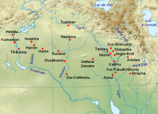
Til Barsip or Til Barsib is an ancient site situated in Aleppo Governorate, Syria by the Euphrates river about 20 kilometers south of ancient Carchemish.

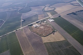
Tell Qarqur is a major archaeological site located in the Orontes River Valley of western Syria. Situated in a rich alluvial plain known as the Ghab valley, the double-mounded site lies near the modern Syrian town of Jisr ash-Shugur and one kilometer west of the village of Qarqur.
Tell Fray is a tell, or settlement mound, on the east bank of the Euphrates in Raqqa Governorate, northern Syria. The archaeological site takes its name from an ancient irrigation canal, hence 'Fray' or 'Little Euphrates'.
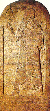
The Kurkh Monoliths are two Assyrian stelae that contain a description of the reigns of Ashurnasirpal II and his son Shalmaneser III. The Monoliths were discovered in 1861 by a British archaeologist John George Taylor, who was the British Consul-General stationed in the Ottoman Eyalet of Kurdistan, in a town called Kurkh, which is now known as Üçtepe, in the district of Bismil, in the province of Diyarbakir of Turkey. Both stelae were donated by Taylor to the British Museum in 1863.
Arjoun, is a village in central Syria, administratively part of the Homs Governorate, located southwest of Homs. Nearby localities include Aqrabiyah to the southwest, al-Qusayr to the southeast, al-Dabaah to the east, Kafr Mousa and al-Ghassaniya to the north and al-Houz to the northwest. According to the Central Bureau of Statistics (CBS), Arjoun had a population of 2,465 in the 2004 census. Its inhabitants are predominantly Sunni Muslims.
Tell Aran is a Kurdish-majority town in northern Syria, administratively part of the al-Safira District of the Aleppo Governorate, located southeast of Aleppo close to Sabkhat al-Jabbul. Nearby localities include Tell Hasil, al-Nayrab and Tell Shughayb to the northwest and al-Safira to the southeast. According to the Syria Central Bureau of Statistics (CBS), Tell Aran had a population of 17,767 in the 2004 census. The town is famous for its grapes, vineyards and gardens. The number of residents of Talaar has exceeded 60,000, especially after the large numbers of people displaced from the city of Aleppo to it due to the bloody war in Syria. The affairs of the town of Talaran are managed through its municipality, which is elected by members of the Baath Party. Muhammad Shadi Murad is currently heading the municipality of Talaran, succeeding Mr. Haitham Hamam.
Qarqur is a village in northern Syria, administratively part of the Hama Governorate, located northwest of Hama. It is situated in the al-Ghab plain, on the eastern bank of the Orontes River. Nearby localities include Jisr al-Shughur 6 kilometers to the north, Farikah to the northeast, Qastun to the southeast, al-Ziyarah 7 kilometers to the south, Sirmaniyah to the southwest and al-Najiyah to the northwest. According to the Syria Central Bureau of Statistics, Qarqur had a population of 2,356 in the 2004 census, making it the largest locality in the al-Ziyarah sub-district (nahiyah).