Marlik

Last updated
Golden Cup depicting Griffin and Pegasus. Excavated at Marlik, Gilan, Iran. First half of first millennium BC. Marlik cup iran.jpg
Golden Cup depicting Griffin and Pegasus. Excavated at Marlik, Gilan, Iran. First half of first millennium BC.
Golden necklace of three Swastikas found in Marlik, dates back to first millennium B.C. Swastika iran.jpg
Golden necklace of three Swastikas found in Marlik, dates back to first millennium B.C.

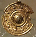
Marlik is an ancient site near Roudbar in Gilan, in northern Iran. Marlik, also known as Cheragh-Ali Tepe [1] is located in the valley of Gohar Rud (gem river), a tributary of Sepid Rud in Gilan Province in Northern Iran, Marlik. Marlik is the site of a royal cemetery, and artifacts found at this site date back to 3,000 years ago. Some of the artifacts contain amazing workmanship with gold. [2] Marlik is named after the Amard people.

Contents

Marlik Cup

Marlik Cup is a cup of pure gold and is 18 cm high. The height of the prominent designs of the cup reaches 2 cm.[ citation needed ]

Pattern of the Marlik Cup on the five hundred rial banknotes of the Pahlavi era. 500 IRR 1981 Back.jpg
Pattern of the Marlik Cup on the five hundred rial banknotes of the Pahlavi era.

Archaeology

The mound at Mārlik is a rocky outcrop capped by several meters of sediment. It is surrounded by olive groves and fruit gardens owned and maintained by local villagers, overlooking rice paddies on the lower slopes of the valley. The site was already partly looted by treasure hunters and the archaeology team were hindered by local corruption [1] [3]

A number of tombs were found. The initial Archaeology report concluded: "In total, fifty-three tombs were discovered at Mārlik. The tombs were dug into the overlaying sediments of the mound, sometimes hitting and penetrating into the underlying bedrock. The tomb constructions vary from roughly dug pits lined with stone to fairly well-constructed examples with walls made from stone slabs bound together with mud mortar. The stone used in the tombs is mostly local, but in some tombs one could see yellowish slabs brought from the headwaters of the Gowharrud, some 15 km to the south. A few, evidently more important, tombs are entirely made of this imported stone, a potential indication to the social significance of the occupant. The tombs range in size from fairly small (1.5x1x1 m [Tomb 4]) to relatively large (7x4.5x2.5 m [Tomb 52]). Most tombs yielded very little or no large skeletal remains, perhaps a result of natural deterioration of organic material and rodent activity. In the handful of tombs, where partial skeletal remains where preserved, the body seemed to have been laid on its side on a large, flattened slab, surrounded by grave goods."

The archaeology is generally assumed to have belonged to a people group who spoke an Iranian language and who migrated into Iran from Central Asia in early to mid-2nd millennium BCE. The abundance of arms, horse-trappings (as well as horse burials), and spouted vessels among the grave goods has been cited as distinct Iranian signatures (Kurochkin). The exact attribution of these people, however, remains largely a conjecture. [4]

See also

Related Research Articles

<span class="mw-page-title-main">Susa</span> Ancient city in Iran

Susa was an ancient city in the lower Zagros Mountains about 250 km (160 mi) east of the Tigris, between the Karkheh and Dez Rivers in Iran. One of the most important cities of the Ancient Near East, Susa served as the capital of Elam and the winter capital of the Achaemenid Empire, and remained a strategic centre during the Parthian and Sasanian periods.

<span class="mw-page-title-main">Kurgan</span> Tumulus in Eastern Europe

A kurgan is a type of tumulus constructed over a grave, often characterized by containing a single human body along with grave vessels, weapons, and horses. Originally in use on the Pontic–Caspian steppe, kurgans spread into much of Central Asia and Eastern, Southeast, Western, and Northern Europe during the third millennium BC.

<span class="mw-page-title-main">Bryn Celli Ddu</span> Neolithic burial chamber on Anglesey

Bryn Celli Ddu is a prehistoric site on the Welsh island of Anglesey located near Llanddaniel Fab. Its name means 'the mound in the dark grove'. It was archaeologically excavated between 1928 and 1929. Visitors can get inside the mound through a stone passage to the burial chamber, and it is the centrepiece of a major Neolithic Scheduled Monument in the care of Cadw. The presence of a mysterious pillar within the burial chamber, the reproduction of the 'Pattern Stone', carved with sinuous serpentine designs, and the fact that the site was once a henge with a stone circle, and may have been used to plot the date of the summer solstice have all attracted much interest.

<span class="mw-page-title-main">Mound of the Hostages</span> Neolithic Passage Tomb in Ireland

The Mound of the Hostages is an ancient passage tomb located in the Tara-Skryne Valley in County Meath, Leinster, Ireland.

<span class="mw-page-title-main">Stone palette</span> Round tray with Greek mythological scenes

A stone palette is a round tray commonly found in the areas of Bactria and Gandhara, and which usually represent Greek mythological scenes. Some of them are attributed to the Indo-Greek period in the 2nd and 1st century BCE Many are considered to be of later production, around the 1st century CE during the time of the Indo-Parthians. They practically disappeared after the 1st century. Many have been found at the archaeological site of Sirkap, in today's Pakistan.

Ezatollah Negahban was an Iranian archaeologist known as the father of Iranian modern archaeology.

<span class="mw-page-title-main">Carnac stones</span> Set of megalithic sites in Brittany, France

The Carnac stones are an exceptionally dense collection of megalithic sites near the south coast of Brittany in northwestern France, consisting of stone alignments (rows), dolmens, tumuli and single menhirs. More than 3,000 prehistoric standing stones were hewn from local granite and erected by the pre-Celtic people of Brittany and form the largest such collection in the world. Most of the stones are within the Breton municipality of Carnac, but some to the east are within neighboring La Trinité-sur-Mer. The stones were erected at some stage during the Neolithic period, probably around 3300 BC, but some may date to as early as 4500 BC.

Haft Tepe is an archaeological site situated in the Khuzestan Province in south-western Iran, about 15 kilometers southwest of the ancient city of Susa. At this site the possible remains of the Elamite city of Kabnak were discovered in 1908, and excavations are still carried out.

<span class="mw-page-title-main">Issyk kurgan</span> Burial mound in Kazakhstan

The Issyk kurgan, in south-eastern Kazakhstan, less than 20 km east from the Talgar alluvial fan, near Issyk, is a burial mound discovered in 1969. It has a height of 6 meters (20 ft) and a circumference of 60 meters (200 ft). It is dated to the 4th or 3rd century BC. A notable item is a silver cup bearing an inscription. The finds are on display in Astana. It is associated with the Saka peoples.

<span class="mw-page-title-main">Amardi</span> Ancient Iranian tribe

The Amardians, widely referred to as the Amardi, were an ancient Iranian tribe living along the mountainous region bordering the Caspian Sea to the north, to whom the Iron Age culture at Marlik is attributed. They are said to be related to, or the same tribe as, the Dahae and Sacae. That is to say, they were Scythian. Herodotus mentions a tribe with a similar name as one of the ten to fifteen Persian tribes in Persis.

<span class="mw-page-title-main">Darband Cave</span> Cave and archaeological site in Iran

Darband Cave is a Lower Paleolithic site in the Gilan Province in northern Iran, located on the north side of a deep tributary canyon of the Siahrud River, a tributary of the Sefīd-Rūd River that flows into the Caspian Sea.

Konar Sandal is a Bronze Age archaeological site, situated in the valley of the Halil River just south of Jiroft, Kermān Province, Iran.

<span class="mw-page-title-main">Horse burial</span> Ritual burial of a horse

Horse burial is the practice of burying a horse as part of the ritual of human burial, and is found among many Indo-European speaking peoples and others, including Chinese and Turkic peoples. The act indicates the high value placed on horses in the particular cultures and provides evidence of the migration of peoples with a horse culture. Human burials that contain other livestock are rare; in Britain, for example, 31 horse burials have been discovered but only one cow burial, unique in Europe. This process of horse burial is part of a wider tradition of horse sacrifice. An associated ritual is that of chariot burial, in which an entire chariot, with or without a horse, is buried with a dead person.

<span class="mw-page-title-main">Royal Cemetery at Ur</span> Archaeological site in southern Iraq

The Royal Cemetery at Ur is an archaeological site in modern-day Dhi Qar Governorate in southern Iraq. The initial excavations at Ur took place between 1922 and 1934 under the direction of Leonard Woolley in association with the British Museum and the University of Pennsylvania Museum of Archaeology and Anthropology in Philadelphia, Pennsylvania, United States.

<span class="mw-page-title-main">San Agustín culture</span>

The San Agustín culture is one of the ancient Pre-Columbian cultures of Colombia. Its beginnings go back at least to the fourth millennium B.C. Several hundred large monolithic sculptures have been found here.

<span class="mw-page-title-main">Indo-Mesopotamia relations</span>

Indus–Mesopotamia relations are thought to have developed during the second half of 3rd millennium BCE, until they came to a halt with the extinction of the Indus valley civilization after around 1900 BCE. Mesopotamia had already been an intermediary in the trade of lapis lazuli between the Indian subcontinent and Egypt since at least about 3200 BCE, in the context of Egypt-Mesopotamia relations.

Tel Mevorakh is a small mound situated on the southern bank of Nahal Taninim in Israel. The tel does not exceed 1 dunam but rises to a height of 15 metres (50 ft) above its surrounding plain. The site contains some fifteen layers of human settlement, which accumulate to a height of 8 meters, meaning the natural hill does not exceed a height of 7 meters. It is located on the border between the wide Sharon Plain and the coast of Mount Carmel.

<span class="mw-page-title-main">Etched carnelian beads</span>

Etched carnelian beads, or sometimes bleached carnelian beads, are a type of ancient decorative beads made from carnelian with an etched design in white, which were probably manufactured by the Indus Valley civilization during the 3rd millennium BCE. They were made according to a technique of alkaline-etching developed by the Harappans, and vast quantities of these beads were found in the archaeological sites of the Indus Valley civilization. They are considered as an important marker of ancient trade between the Indus Valley, Mesopotamia and even Ancient Egypt, as these precious and unique manufactured items circulated in great numbers between these geographical areas during the 3rd millennium BCE, and have been found in numerous tomb deposits.

<span class="mw-page-title-main">Citadel of Cadusii</span>

Citadel of Cadusii was discovered during archaeological research in Kaluraz in the province of Gilan, Iran. It was used as a frontier fortress and protected from the invasion of people from Amardi and Marlik in the region.

<span class="mw-page-title-main">Uyuk culture</span>

The Uyuk culture refers to the Saka culture of the Turan-Uyuk depression around the Uyuk river, in modern-day Tuva Republic.

References

  1. 1 2 D. Josiya Negahban, Marlik.
  2. Langer, William L., ed. (1972). An Encyclopedia of World History (5th ed.). Boston, MA: Houghton Mifflin Company. pp.  17. ISBN   0-395-13592-3.
  3. Marlik : the complete excavation report: Archaeological report(University Museum, University of Pennsylvania, 1994) p15-24.
  4. ʿE.-A. Negahbān, “The Wonderful Gold Treasure of Marlik,” Illustrated London News, 28 April 1962, pp. 663-64.

36°49′50″N49°27′33″E / 36.83056°N 49.45917°E / 36.83056; 49.45917