Larsa (Sumerian: 𒌓𒀕𒆠, romanized:UD.UNUGKI,[1] read Larsamki[2]), also referred to as Larancha/Laranchon (Gk. Λαραγχων) by Berossos and connected with the biblical Ellasar, was an important city-state of ancient Sumer, the center of the cult of the sun godUtu with his temple E-babbar. It lies some 25km (16mi) southeast of Uruk in Iraq's Dhi Qar Governorate, near the east bank of the Shatt-en-Nil canal at the site of the modern settlement Tell as-Senkereh or Sankarah.
Larsa is found (as UD.UNUG) on Proto-cuneiform lexical lists from the Uruk 4 period (late 4th millennium BC). A few Proto-cuneiform tablets were also found there.[4] Three Neolithic clay tokens, from a slightly early period, were also found at Larsa.[5][6] For most of its history Larsa was primarily a cult site for the god Utu. In the early part of the 2nd millennium BC the First Dynasty of Lagash made it a major power for perhaps two centuries. The last known occupation was in the Hellenistic period.
3rd Millennium BC
The historical "Larsa" was already in existence as early as the reign of Early Dynastic ruler Eannatum of Lagash (circa 2500–2400 BC), who annexed it to his empire. In a large victory stele found at Girsu he wrote:
"... E-anatum was very clever indeed and he made up the eyes of two doves with kohl, and adorned their heads with cedar (resin). For the god Utu, master of vegetation, in the E-babbar at Larsa, he had them offered as sacrificial bulls."[7]
A later ruler, Entemena, nephew of Eannatum, is recorded on a foundation cone found at nearby Bad-Tibira as cancelling the debts of the citizens of Larsa "He cancelled [oblig]ations for the citizens of Uruk, Larsa, and Pa-tibira ... He restored (the second) to the god Utu’s control in Larsa ...".[7] Larsa is attested in the Akkadian Empire in the Temple Hymns of Enheduanna, daughter of Sargon of Akkad.
"... Your lord is the soaring sunlight, the ruler ... righteous voice. He lights up the horizon, he lights up the zenith of heaven. Utu, lord of the Shining House,has built a home in your holy court, House of Larsa, and has taken his seat upon your throne."[8]
In the Ur III empire period that ended the millennium, its first ruler Ur-Nammu recorded, in a brick inscription found at Larse, rebuilding the E-babbar temple of Utu there.[9]
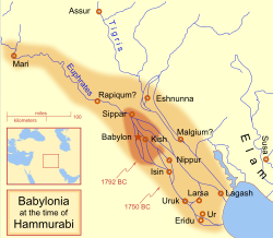
The city became a political force during the Isin-Larsa period. After the Third Dynasty of Ur collapsed c. 2004 BC, Ishbi-Erra, an official of the last king of the Third Dynasty of Ur, Ibbi-Sin, relocated to Isin and set up a government which purported to be the successor to the Third Dynasty of Ur. From there, Ishbi-Erra recaptured Ur as well as the cities of Uruk and Lagash, which Larsa was subject to. Subsequent rulers of Isin appointed governors to rule over Larsa; one such governor was an Amorite named Gungunum. He eventually broke with Isin and established an independent dynasty in Larsa. To legitimize his rule and deliver a blow to Isin, Gungunum captured the city of Ur. In his year names he recorded the defeat of the distant Anshan in Elam as well as city-states closer to Larsa such as Malgium. As the region of Larsa was the main center of trade via the Persian Gulf, Isin lost an enormously profitable trade route, as well as a city with much cultic significance.
Gungunum's two successors, Abisare (c. 1905–1894 BC) and Sumuel (c. 1894–1865 BC), both took steps to cut Isin completely off from access to canals. Isin quickly lost political and economic influence.
Detail of a terracotta cylinder of Nabonidus, recording the restoration work on the temple of Shamash at Larsa. Dated to 555–539 BCE. Probably from Larsa, Iraq. Housed in the British Museum
Larsa grew powerful, but never accumulated a large territory. At its peak under king Rim-Sin I (c. 1822–1763 BC), Larsa controlled about 10–15 other city-states. In the latter half of this period the city of Mashkan-shapir acted as a second capital of the city-state.[10][11] Nevertheless, huge building projects and agricultural undertakings can be detected archaeologically. After the defeat of Rim-Sin I by Hammurabi of Babylon, Larsa became a minor site, though it has been suggested that it was the home of the First Sealand Dynasty of Babylon.[12]
1st Millennium BC
Larsa was known to be active during the Neo-Babylonian, Achaemenid, and Hellenistic periods based on building brick inscriptions as well as a number of cuneiform texts from the Larsa temple of Samash which were found in Uruk.[13][14][15][16] The E-babbar of Utu/Shamash was destroyed by fire in the 2nd century BC and the area re-used for poorly built private homes.[17] The entire site was abandoned by the 1st century BC.[18]
List of rulers
The following list should not be considered complete:
List of the kings of Larsa, 39th year of Hammurabi's reign, LouvreCompilation of plane geometry problems from Larsa, Old Babylonian period.
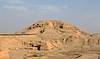
The remains of Larsa cover an area of about 200 hectares. The highest point is around 70ft (21m) in height.
The site of Tell es-Senkereh was first excavated, under the rudimentary archaeological standards of his day, by William Loftus in 1850 for less than a month.[21] Loftus recovered building bricks of Nebuchadnezzar II of the Neo-Babylonian Empire which enabled the site's identification as the ancient city of Larsa. Much of the effort by Loftus was on the temple of Shamash, rebuilt by Nebuchadnezzar II. Inscriptions of Burna-Buriash II of the Kassite dynasty of Babylon and Hammurabi of the First Babylonian dynasty were also found. Larsa was also briefly worked by Walter Andrae in 1903. The site was inspected by Edgar James Banks in 1905. He found that widespread looting by the local population was occurring there.[22]
The first modern, scientific, excavation of Senkereh occurred in 1933, with the work of André Parrot.[23][24] Parrot worked at the location again in 1967.[25][26] In 1969 and 1970, Larsa was excavated by Jean-Claude Margueron.[27][28] Between 1976 and 1991, an expedition of the Delegation Archaeologic Francaise en Irak led by J-L. Huot excavated at Tell es-Senereh for 13 seasons.[29][30][31][32] The primary focus of the excavation was the Neo-Babylonian E-Babbar temple of Utu/Shamash. Floors and wall repairs showed its continued use in the Hellenistic period. A tablet, found on the earliest Hellenistic floor, was dated to the reign of Philip Arrhidaeus (320 BC). Soundings showed that the Neo-Babylonian temple followed that plan of the prior Kassite and earlier temples.[33] Numerous inscriptions and cuneiform tablets were found representing the reigns of numerous rulers, from Ur-Nammu to Hammurabi all the way up to Nebuchadnezzar II.[34][35]
In 2019 excavations were resumed. The first season began with a topographic survey, by drone and surface survey, to refine and correct the mapping from early excavations. Excavation was focused on a large construction of the Hellenistic period built north of the E-Babbar temple.[36][37] The first season included a magnetometer survey.[38] Excavations continued with one month seasons in 2021 and 2022. They have been able to trace a very large system of internal canals and a port area, all linked to the Tigris and Euphrates rivers in Old Babylonian times. In a destroyed level of the Grand Viziers residence 59 cuneiform tablets, fragments and envelopes dated to the time of Gungunum and Abisare were found. Geophysical work continued including on the 10-20 meter wide rampart wall that enclosed Larsa, with six main gates.[39]
↑ Charvát, Petr, "From King to God: The NAMEŠDA Title in Archaic Ur", in Organization, Representation, and Symbols of Power in the Ancient Near East: Proceedings of the 54th Rencontre Assyriologique Internationale at Würzburg 20–25 Jul, edited by Gernot Wilhelm, University Park, USA: Penn State University Press, pp. 265-274, 2012
↑ Schmandt-Besserat, Denise. Before writing: From counting to cuneiform, Vol. II, University of Texas Press, 1992
↑ Overmann, Karenleigh A., The Material Origin of Numbers: Insights from the Archaeology of the Ancient Near East, Piscataway, NJ, USA: Gorgias Press, Table 9.2, pp. 169-170, 2019
1 2 Douglas Frayne, "Lagas", in Presargonic Period: Early Periods, Volume 1 (2700-2350 BC), RIM The Royal Inscriptions of Mesopotamia Volume 1, Toronto: University of Toronto Press, pp. 77-293, 2008 ISBN 9780802035868
↑ Helle, Sophus, "The Temple Hymns", in Enheduana: The Complete Poems of the World's First Author, New Haven: Yale University Press, pp. 53-94, 2023
↑ Frayne, Douglas, "Ur-Nammu E3/2.1.1". Ur III Period (2112-2004 BC), Toronto: University of Toronto Press, pp. 5-90, 1997
↑ Steinkeller, P., "A History of Mashkan-shapir and Its Role in the Kingdom of Larsa", In E. C. Stone & P. Zimansky (eds.), The Anatomy of a Mesopotamian City. Survey and Soundings at Mashkan-shapir, Winona Lake: Eisenbrauns, pp. 26-42, 2004
↑ Ali Ahmed Gadalla, Azza, "The City of Mashkan-Shabir and The Kingdom of Larsa", Annals of the Faculty of Arts, Ain Shams University 50.13, pp. 294-321, 2022
↑ Beaulieu, Paul-Alain, "Neo-Babylonian Larsa: A Preliminary Study", Orientalia, vol. 60, no. 2, pp. 58–81, 1991
↑ Boivin, O., "The ilku and Related Fiscal Obligations in Sixth Century Larsa", in: K. Kleber (ed.), Taxation in the Achaemenid Empire (Classica et Orientalia 26), Wiesbaden, pp. 153–176, 2021
↑ Beaulieu, P.-A., "A Finger in Every Pie: The Institutional Connections of a Family of Entrepreneurs in Neo-Babylonian Larsa", in: A.C.V.M. Bongenaar (ed.), Interdependency of Institutions and Private Entrepreneurs: Proceedings of the Second MOS Symposium, Leiden 1998 (PIHANS 87), Leiden, pp. 43–72, 2000
↑ Joannès, F., "Les débuts de l’époque hellénistique à Larsa", in: C. Breniquet/C. Kepinski (ed.), Études mésopotamiennes. Recueil de textes offerts à Jean-Louis Huot, Paris, pp. 249–264, 2001
↑ Lecomte, O., "Stratigraphical analysis and ceramic assemblages of the 4th–1st centuries B. C. E.Babbar of Larsa", in: U. Finkbeiner (ed.), Materialien zur Archäologie der Seleukiden- und Partherzeit im südlichen Babylonien und im Golfgebiet, Tübingen, pp. 17–39, 1993
↑ Westenholz, Aage, "The Graeco-Babyloniaca Once Again", Zeitschrift für Assyriologie und Vorderasiatische Archäologie , vol. 97, no. 2, pp. 262-313, 2007
↑ Weisberg, David B., "Zabaya, an Early King of the Larsa Dynasty", Journal of Cuneiform Studies, vol. 41, no. 2, pp. 194–98, 1989
↑ Fiette, Baptiste, "“King” Kudur-Mabuk. A Study on the Identity of a Mesopotamian Ruler Without a Crown", Die Welt des Orients, vol. 50, no. 2, pp. 275-294, 2020
↑ Andre Parrot, "Villes enfouies. Trois campagnes de fouilles en Mésopotamie", 1935
↑ A. Parrot, "Les fouilles de Tello et de. Senkereh-Larsa, campagne 1932–1933", Revue d'Assyriologie, 30, pp. 169–182, 1933
↑ André Parrot, "Les fouilles de Larsa", Syria, 45, pp. 205–239, 1968
↑ Parrot, André, "Les Fouilles de Larsa. Deuxième et Troisième Campagnes (1967)", Syria, vol. 45, no. 3/4, pp. 205–39, 1968
↑ Jean-Claude Margueron, "Larsa, rapport preliminaire sur la quatrieme campagne", Syria, 47, pp. 261-277, 1970
↑ Jean-Claude Margueron, "Larsa, rapport preliminaire sur la cinquieme campagne", Syria, 48, pp. 271–287, 1971
↑ J. L. Huot et al., "Larsa, Preliminary Report on the Sixth Campaign", Sumer, 34, pp. 140–164, 1978
↑ J-L. Huot, "Larsa, rapport preliminaire sur la septieme campagne Larsa et la premiere campagne Tell el 'Oueili (1976)", Syria, 55, pp. 183–223, 1978
↑ J-L. Huot, "Larsa et 'Oueili, travaux de 1978–1981", vol. 26, Memoire, Editions Recherche sur les civilisations, 1983 ISBN2-86538-066-1
↑ J-L. Huot, "Larsa, Travaux de 1985", Editions Recherche sur les civilisations, 1989 ISBN2-86538-198-6
↑ J.-L. Huot, "Larsa (10e campagne, 1983) et Oueili: Rapport preliminaire", Editions Recherche sur les civilisations, 1987 ISBN2-86538-174-9
↑ D. Arnaud, "French Archaeological Mission in Iraq. A Catalogue of the Cuneiform Tablets and Inscribed Objects Found during the 6th Season in Tell Senkereh/Larsa", Sumer, 34, pp. 165–176, 1978
↑ Huot, J.-L., "L’E. babbar de Larsa aux IIe et Ier millénaires (fouilles de 1974 à 1985)", BAH 205, Beyrouth, 2014
Judith K. Bjorkman, "The Larsa Goldsmith's Hoards-New Interpretations", Journal of Near Eastern Studies, vol. 52, no. 1, pp.1–23, 1993
T. Breckwoldt, "Management of grain storage in Old Babylonian Larsa", Archiv für Orientforschung, no. 42–43, pp.64–88, 1995–1996
Calvet, Y., et al., "Larsa Rapport Préliminaire Sur La Sixième Campagne de Fouilles", Syria, vol. 53, no. 1/2, pp.1–45, 1976
Calvet Y., "Un niveau protodynastique à Larsa", Huot J.-L. (ed.), Larsa. Travaux de 1987 et 1989, BAH 165, Beyrouth, pp.23–28, 2003
Charpin, D. 2018, "En marge d’EcritUr, 1: un temple funéraire pour la famille royale de Larsa?", Notes Assyriologiques Brèves et Utilitaires 2018, no 1, 2018
Charpin, D., "Enanedu et les prêtresses-enum du dieu Nanna à Ur à l’époque paléo-babylonienne", in D. Charpin, M. Béranger, B. Fiette & A. Jacquet, Nouvelles recherches sur les archives d’Ur d’époque paléo-babylonienne. Mémoires de N.A.B.U. 22, Paris: Société pour l’Étude du Proche-Orient ancien, pp.187–210, 2020
Feuerherm, Karljürgen G., "Architectural Features of Larsa’s Urban Dwelling B 27", Journal of Near Eastern Studies, vol. 66, no. 3, pp.193–204, 2007
Huot, J.-L., Rougeulle, A., Suire, J., "La structure urbaine de Larsa, une approche provisoire", in J.-L. Huot (ed.), Larsa, Travaux de 1985, ERC, Paris, pp.19–52, 1989
Huot, Jean-Louis, et al., "Larsa. Rapport Préliminaire Sur La Huitième Campagne a Larsa et La Deuxième Campagne a Tell El ’Oueili (1978)", Syria, vol. 58, no. 1/2, pp.7–148, 1981
Kaerki, Ilmari, Die sumerischen und akkadischen Königsinschriften der altbabylonischen Zeit 1. - Isin, Larsa, Uruk, Studia orientalia 49, Helsinki, 1980, ISBN951-95075-6-6.
W.F. Leemans, "Legal and economic records from the Kingdom of Larsa", Brill, 1954 ISBN90-6258-120-X
This page is based on this Wikipedia article Text is available under the CC BY-SA 4.0 license; additional terms may apply. Images, videos and audio are available under their respective licenses.