The name is from the West Semitic (Canaanite) root Q-D-Š "holy". It is rendered Qdšw[1] or Qdš[2] in Egyptian hieroglyphic and Kinza in Hittite.[3] The place name appears in several slightly different Akkadian spellings in the Amarna letters, including Qidšu (EA 162, 188, 189, 190 [4]), Qidši (EA 53, 151 [5]), Qinsa (EA 54, 174, 175, 176, 363 [6]), and Qissa (EA 197 [7]); these are sometimes spelled less accurately as Kidša, Kinza, and Gizza.[8] On this basis, Trevor Bryce observes that the Late Bronze Age name "was probably pronounced Qidš(a), with 'Qadesh' being a mispronunciation by mod. scholars."[9] The Iron Age form of the name in Neo-Assyrian Akkadian is Qadīsu.[10]
Some scholars also identify Kadesh with the city of Kadytis (Καδύτις in Greek) mentioned by Herodotus (2.159, an alternative identification for Kadytis being Gaza.[8]
History
Early Bronze Age
Following an occupation of the site during the Pottery Neolithic (seventh millennium BC), there was a period of abandonment, before the site was reoccupied in the third millennium BC.[12] In the late Early Bronze Age, the site is known for White-on-Blackweel Ware pottery. This ware appeared in the transitional EB III/IV (Phase O), flourished and was traded in the Orontes Valley up to the Plains of Antioch and to eastern North Syria in EB IVA (Phase N).[13] In EB IVB (Phase M), the ware continued features from the previous phase, but is easily distinguishable. It disappeares in the transitional EB IV/MB I (Phase L). Comparison should be made with Hama J7-5 (EB IVA) and J4-2 (EB IVB).
Middle Bronze Age
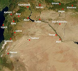
Map of Syria in the second millennium BC, showing the location of Kadesh (Qadesh)
The city first entered historical records when it was mentioned in the archive of Mari in the 18th century BC as the headquarters of king Ishi-Addu of Qatna during the suppression of a rebellion in the south of the city.[14]
In Inner Syria, the Middle Bronze ends with the military campaigns of Muršili I of Hatti (c. 1595 BC, according to the commonly cited Mesopotamian Middle Chronology). Here the MB IIB is followed by LB IA, while MB IIC starts in the southern Levant. About this time, there is a further possible destruction and abandonment of Kadesh, quickly followed by rebuilding.[12]
Late Bronze Age
Period of Mittanian overlordship
Kadesh came under the influence of Mittani influence after the murder of Muršili I of Hatti (c. 1587 BC) and the subsequent decline of the Old Hittite Kingdom. The Mitanni confederation emerged from the Habur region, and the small kingdoms of northern Syria became its allies or vassals.[12]
Around 1490 BC (according to the commonly cited Egyptian Low Chronology), the Egyptian king Thutmose I campaigned north into Syria against Mittani, along with Aram, an ally of Kadesh. In the time of Hatshepsut there were no campaigns against Kadesh as she was focused on developing trade across the Red Sea and southward.[citation needed]
Period of Egyptian overlordship
Battle of Megiddo. Kadesh is noted as one of two Canaanite cities (with Megiddo) that led a coalition of city-states opposing the conquest of the Levant by the Egyptian king Thutmose III. The king of Kadesh was probably encouraged in this resistance by the ruler of Mittani, Egypt's primary foreign rival the Levant. Egyptian victory in the subsequent Battle of Megiddo (1457 BC) led to the establishment of Egyptian hegemony over Kadesh, along with other parts of southern and western Syria.
Amarna Letters. Following further Egyptian military activity under Amenhotep II, Thutmose IV established peace between Egypt and Mittani, and Kadesh continued as Egyptian vassal. The troubled relations among Egyptian vassals in Syria are reflected in the diplomatic correspondence between them and the Egyptian king Akhenaten preserved at his capital Amarna. Kadesh is mentioned several times, under the name Qidšu (and variants) in these Akkadian language letters. At least one of the letters (EA 189) was sent to Akhenaten by Aitakkama, the king of Kadesh himself.[15]
Period of Hittite overlordship
Around 1350 BC, Šuppiluliuma I of Hatti attacked Tušratta of Mittani, conducting military campaigns against Mittanian strongholds, and then taking control over vassal rulers west of the Euphrates River in Syria. This expansion eventually impacted Egyptian interests and eventually both Aziru of Amurru and Aitakkama of Kadesh became Hittite vassals. Kadesh's northern neighbor, Qatna, which had been the regional capital in the Middle Bronze, now came to an end facing the Hittites. When Aitakkama of Kadesh sought Egyptian support to assert his independence from the Hittites, he was murdered by his son Niqmaddu, who took over Kadesh and duly reaffirmed its loyalty to the Hittite king Muršili II.[16]
The names of three kings of Kadesh survive from contemporary sources: Šuttarna (or Šutatarra; fl. c. 1350 BC);[17][18]Aitakkama (c. 1340s–1312 BC) and his son Niqmaddu (fl. c. 1312 BC).
Campaign of Seti I
Seti I stele fragment from Tell Nebi Mend (Kadesh)
The city was captured by the great pharaoh Seti I (1290–1279 BC), during his campaign to Syria. Kadesh had been lost to Egypt since the time of Akhenaten, and Seti's predecessors Tutankhamun and Horemheb had both failed to recapture the city from the Hittites. Seti I was successful here and defeated a Hittite army that tried to defend it. He triumphantly entered the city together with his son Ramesses II and erected a victory stela at the site.[19][20]
Seti's success, however, was only temporary. As soon as Seti returned to Egypt, the Hittite king, probably Muwattalli II, marched south to take Kadesh and made it a stronghold of the Hittite defenses in Syria. The Hittites dominated northern Syria through their viceroy at Carchemish.[16]
Egyptian relief dating to Ramesses II's reign, depicting Kadesh garrisoned by Hittites and surrounded by the Orontes River.
The city is best known for one of the earliest extensively documented battles of the ancient world, the Battle of Kadesh between the superpowers of the 13th century BC, the Egyptian and Hittite Empires. An Egyptian vassal for some 150 years, Kadesh had eventually defected to Hittite suzerainty, thereby placing the city on the contested frontier between the two rival empires.
In response to this Hittite expansion southwards, the Egyptian pharaoh Ramesses II (1279–1213 BC) prepared an aggressive military response and captured the coastal state of Amurru in his Year 4. The next year, the Hittites moved south to recover Amurru, while the Egyptians moved north to continue their expansion into Syria. The inhabitants of Kadesh had cut a channel from the river to a stream south of the town, which had turned the town into a virtual island.
In May 1274 BC, Year 5 of Ramesses' reign, he led a large force of chariots and infantry 1,000 miles (1,600km) to retake the walled city. In the Battle of Kadesh, the two forces clashed on the plain west of the city and the Orontes River, in what is widely regarded as the largest chariot versus chariot battle in history (5,000–6,000 between the two sides). The battle saw the Egyptians turning a near catastrophe into a near victory. After Hittite spies convinced the Egyptians that the Hittites were far away, the Hittites ambushed Ramesses in his camp. Ramesses rallied his bodyguard and broke out of the trap in time for the last-minute arrival of a supporting Egyptian force from coastal Amurru. The pharaoh was able to recover the initiative, to repulse the attack, and to remain in control of the battlefield.[21] Although the Hittite trap and attack had failed, Ramesses was unable to continue the campaign and had to return home to Egypt.[16]
Aftermath
Following the battle, Kadesh remained under Hittite overlordship, Amurru returned to the Hittite fold, while the Hittite army was able to raid southward as far as Upi, in the neighborhood of Damascus. By Year 8 of Ramesses II's reign (1272 BC), the Egyptians were back on the offensive, reaching northwards beyond Kadesh to Dapur and Tunip, but do not appear to have made any lasting gains.[22][23]
The subsequent impasse between Egypt and Hatti was resolved in one of the earliest known international peace treaties, concluded 15 years later between Ramesses II and the Hittite king Ḫattušili III. The treaty essentially accepted the status quo, with Amurru and Kadesh continuing as Hittite vassals.[24]
End of Kadesh
Kadesh was probably destroyed by the invading Sea Peoples around 1178 BC.[16] It was, however, reoccupied, and is attested in Neo-Assyrian administrative texts under the name Qadīsu.[25] Hellenistic remains have been found in the upper levels of the tell mound, the summit of which is still occupied today. In Byzantine times, widespread occupation is evidenced by extensive remains at the foot of the tell. The Hellenistic city of Laodicea ad Libanum is believed to have occupied the same site as ancient Kadesh.[16] Continuous occupation throughout the Islamic period is likely, the mound having been named after a local Muslim holy man, Nebi Mend.
Tell Nebi Mend
Tell Nebi Mend, consisting of an upper (450 x 200 meter) and lower tell, lies 10 kilometers southwest of the modern city of Homs and covers an area of about 10 hectares and rises to a height of about 30 meters over the plain. An enclosure wall around the site, thought to be Middle Bronze Age, encompasses about 40 hectares. Located at the confluence of the Orontes River and Mukadiya river, it was occupied through the Neolithic (followed by a break in occupation), Bronze Age, Iron Age, and Hellenistic/Roman periods.[26][27]
The site was first excavated by a French team led by Maurice Pezard in 1922 and 1923, in the northeast quadrant of the upper mound. The excavator opened two trenches, one 60 meters by 25 meters, and 20 meters deep and the other 30 by 40 meters by 70 meters and shallow.[28] Finds included an incomplete stele of Pharaoh Seti I (c. 1294/1290–1279 BC) in a out-of-context Iron Age level, some stone statuettes and Syro-Hittite cylinder seals, and a terracotta figurine.[29][30]
The site was then excavated between 1975 and 1995 by a team from the University College London Institute of Archaeology led by Peter Parr. Nine trenches were opened, all on the upper mound, with excavated levels ranging from Middle Bronze I to Late Bronze II. A number of charcoal samples were radiocarbon dated though there were apparently technical problems that limited their usefulness.[31][32][33] Six cuneiform tablets were found at the site, one blank with sealing and the others in a Babylonian dialect of Akkadian. The tablets, from the late 14th century BC, mentioned the name of a ruler, Niqmadda, and provided confirmation of the site as Qadesh.[34][35]
The site has received damage in the Syrian Civil War.[36]
↑ Marta D'Andrea (2017) Note on Early Bronze IV Grey Hard-Textured Wares in the Levant, Studia Eblaitica 3, pp. 172-181.
↑ Ziegler, Nele (2007). "Les données des archives royales de Mari. sur le milieu naturel et l'occupation humaine en Syrie centrale". In Morandi Bonacossi, Daniele (ed.). Urban and Natural Landscapes of an Ancient Syrian Capital. Settlement and Environment at Tell Mishrifeh/Qatna and in Central-Western Syria (Proceedings of the International Conference held in Udine9-11 December 2004). Studi archeologici su Qatna. Vol.1. Forum Editrice Universitaria Udinese. ISBN978-88-8420-418-9.
↑ Archived 2024-01-04 at the Wayback Machine Bourke, SJ, "The transition from the Middle to the Late Bronze Age in the northern Levant: The evidence from Tell Nebi Mend, Syria", Doctoral thesis (Ph.D), UCL (University College London), 1992
↑ Bourke, Stephen J., "The transition from the Middle to the Late Bronze Age in Syria: the evidence from Tell Nebi Mend", Levant 25.1, pp. 155-195, 1993
↑ Archived 2024-01-04 at the Wayback Machine Nishiaki, Yoshihiro, "Lithic technology of Neolithic Syria: A series of analyses of flaked stone assemblages from Douara Cave II, Tell Damishilyya, Tell Nebi Mend and Tell Kashkashok II", University of London, University College London, pp. 209-248, 1992
↑ Archived 2024-01-04 at the Wayback Machine Pézard, Maurice, "Mission Archéologique a Tell Nebi Mend (1921): Rapport Sommaire", Syria, vol. 3, no. 2, pp. 89–115, 1922
↑ Maurice Pezard, "Kadesh: Mission Archaeologique a Tell Nebi Mend, 1921-1922", Paris: Libraire Orientaliste, Paul Geuthner, 1931
↑ Peter J. Parr (ed.), "Excavations at Tell Nebi Mend, Syria: volume 1 (Levant Supplementary Series 16)", Oxford: Oxbow, 2015 ISBN978-1-78297-786-5
↑ Bourke, Stephen J., "Sequence, chronology and culture at Tell Nebi Mend in the Middle and Late Bronze Ages", A Land in Between: The Orontes Valley in the Early Urban Age, pp. 229-266, 2020
↑ Eriksson, K. O., S. J. Bourke, and J. B. Hennessy, "A Middle Cypriot sherd from Trench I, Tell Nebi Mend, Syria", Ägypten und Levante/Egypt and the Levant 10, pp. 205-210, 2000
↑ Millard, Alan, "The Cuneiform Tablets from Tell Nebi Mend", Levant 42.2, pp. 226-236, 2010
↑ Singer, Itamar, "The historical context of two Tell Nebi Mend/Qadeš letters", Kaskal, 8, pp. 161-175, 2011
Breasted, James Henry, Ancient Records of Egypt, vols. 2 and 3, Chicago 1906.
Bryce, Trevor, The Routledge Handbook of The Peoples and Places of Ancient Western Asia, London 2009.
Grigson, Caroline, "The fauna of Tell Nebi Mend (Syria) in the Bronze and Iron Age—a diachronic overview. Part 1: Stability and change—animal husbandry", Levant 47.1, pp.5–29, 2015
Grigson, Caroline, Yvonne Edwards, and Ruby Cerón-Carrasco, "The fauna of Tell Nebi Mend (Syria) in the Bronze and Iron Age—a diachronic overview. Part 2: hunting, fowling and fishing", Levant 47.2, pp.164–185, 2015
Ignatov, Sergey, "Dardanians, Moesians and Phrygians in the Qadesh Inscriptions of Ramses II", Thracia 11 (1995) 107-112 (= Studia in honorem Alexandri Fol, Sofia 1995: 223-231)
Kennedy, Melissa, "A New EB IV Cultural Province in Central and Southern Syria: The View from Tell Nebi Mend", in Pearls of the Past: Studies on Near Eastern Art and Archaeology in Honour of Frances Pinnock. Zaphon, pp.429–448, 2019
Kennedy, Melissa A., Kamal Badreshany, and Graham Philip, "Drinking on the periphery: the Tell Nebi Mend goblets in their regional and archaeometric context", Levant 52.1-2, pp.103–135, 2020
Mathias, V.T. and Parr, P.J., "The early phases at Tell Nebi Mend: A preliminary account", Levant XXI, pp.13–33, 1989
Mathias, V.T., "The Early Bronze Age Pottery of Tell Nebi Mend in its Regional Setting", in G. Philip and D. Baird (eds) Ceramics and Change in the Early Bronze Age of the Southern Levant, Sheffield Academic Press, Sheffield, pp.411–427, 2000
Oded, B., "Two Assyrian References to the Town of Qadesh on the Orontes", Israel Exploration Journal, vol. 14, no. 4, pp.272–73, 1964
Parpola, Simo, and Michael Porter, The Helsinki Atlas of the Near East in the Neo-Assyrian Period, Helsinki 2001.
Rainey, Anson F., and W. M. Schniedewind, The El-Amarna Correspondence, Leiden: Brill 2015.
Whincop, M.R., "The Iron Age II at Tell Nebi Mend: towards an explanation of ceramic regions", Levant 39, pp.185–212, 2007
This page is based on this Wikipedia article Text is available under the CC BY-SA 4.0 license; additional terms may apply. Images, videos and audio are available under their respective licenses.