Tel Yarmuth

Last updated
Tel Yarmuth
Tel-Yarmuth-2-33721.jpg
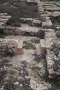
Tel Yarmuth (Khŭrbet el-Yarmûk)
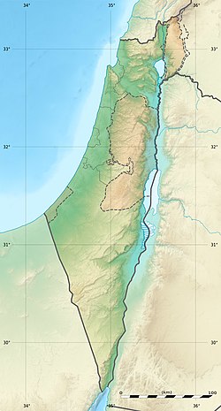
Israel relief location map.jpg
Archaeological site icon (red).svg
Shown within Israel
Alternative nameTel Yarmouth
LocationIsrael
Coordinates 31°42′36″N34°58′48″E / 31.71000°N 34.98000°E / 31.71000; 34.98000
Grid position147/124 PAL
Typesettlement
Area18 ha
History
Foundedcirca 3000 BC
Abandoned3rd millennium BC
Periods Bronze Age
CulturesEarly Dynastic Period
Site notes
Excavation dates1970. 1990-present
ArchaeologistsAmnon Ben-Tor (1970), Pierre de Miroschedji (1980), Paz Yitzhak (2014), Mizrahi Sivan (2014), Adawi Zubair (2014), Haber Michal (2014), Radshkovsky Igal (2014), Zilberbod Irina (2014), Greenvald Roie (2014), Sapir Neria (2014), Yoav Tsur (2014), Eirikh-Rose Anna (2014)
ConditionRuined
OwnershipPublic
Public accessYes

Tel Yarmuth (also Tel Yarmouth and Tel Yarmut; Hebrew name) or Khirbet Yarmuk (Arabic name) is an ancient Near East archaeological site in Israel located 25 kilometers southwest of Jerusalem and near modern Beit Shemesh. It is a large primarily single-period (EB II/III) site and has been suggested as possibly being the city of Jarmuth, being only a tentative identification, as it is based solely on the similarity of the Hebrew name with the Arabic name and its areal location. [1] [2]

Contents

History

Early Bronze Age

Chronologically the city reached its peak at the same time as the Old Kingdom in Egypt and the Early Dynastic III period in Mesopotamia. After that the city was abandoned, with modest occupation in later periods.

Early Bronze period material from Tel Yarmuth has been radiocarbon dated and is being used to support the contention that EB III ended around 2500 BC. Samples tested were "3 from Final EB IB, 15 from EB II, and 19 from EB III". Results were Final EB IB to EB II transition between 3030 and 2960 BC, EB II to EB III transition between 2980 and 2910 BC. [3] [4] [5]

Early Bronze IB

The only notable EB IB find was a basalt spindle whorl. [6]

Early Bronze II-III

The entire site including the lower town was heavily occupied in the Early Bronze (EB) II and III periods. [7] [8] The site was abandoned around 2400 BC, during EB III. [6]

Early Bronze Age vessel found at Tel Yarmuth Eretz-Israel-Museum-ceramics-pavilion-tel-yarmut-early-bronze-42402.jpg
Early Bronze Age vessel found at Tel Yarmuth

The EB II and III monumental construction includes the large "White Building", a plastered masonry broad-room temple with a side altar. In this period two large palaces were built with one, Palace B1, measuring 1750 square meters and the other, Palace B2, measuring 6000 square meters. [9] At its peak the city had massive sophisticated fortifications and a large main city gate (Area E). The first city wall (Wall A) was made of stone, was 6 meters deep and is preserved to 4 meters in height. A larger wall (Wall B) was later added outside of that built of cyclopean construction. The fortifications were subsequently improved even further. [7] [8] A number of EB III flint Canaanite blades, believed to be used as sickle inserts or in threshing, were found. [6]

Middle Bronze

The acropolis was lightly re-occupied, based on potsherd finds, in the Middle Bronze IIA.

Late Bronze

The site saw some occupation in the Late Bronze II. It included 13th century BC Mycenaean and Cypriot sherds. The only other epigraphic find was a hoe with a partial hieroglyphic inscription in a hoard of bronze objects, mostly fragmentary. They were dated to the time of the 19th Dynasty (12th century BC) and may not be in their original context. [6]

Iron Age

Somewhat more substantial building occurred on the acropolis in Iron I times. Finds from that period included a 2nd-century BC cooking pot with a yršlm (Jerusalem) stamp. [10] [11]

In the Hebrew Bible, Joshua 15:33–36, Yarmuth (Jarmuth) is mentioned along with the cities Adullam and Socho as occupying a place in the Land of Canaan, in the region geographically known as the Shefelah, or what is a place of transition between the mountainous region and the coastal plains. Also in the Hebrew Bible, Joshua 12:7–11, the king of Yarmuth (Jarmuth) was slain by Joshua and the Israelites during their conquest of the land of Canaan.

Period of the monarchy

In the late 8th-century BC (ca. 700 BC), Yarmuth was in the territorial domain belonging to King Hezekiah. In the 14th-year of King Hezekiah's reign, Sennacherib embarked on his third military campaign, this time against the cities of the Levant, including against the king of Sidon and against Jerusalem in Judah, where King Hezekiah was besieged, based on 2 Kings 18:137 in the Hebrew Bible. Many of the king's important cities in Judah were at that time taken by Sennacherib and given over to other potentates faithful to Sennacherib. Although Yarmuth is not specifically named in the prism (Sennacherib's Annals) detailing Sennacherib's exploits, it can be assumed by the account that the city did not go unscathed:

"As for Hezekiah, the Jew, who did not submit to my yoke, forty-six of his strong, walled cities, as well as the small cities in their neighborhood, which were without number...I besieged and took. Two-hundred thousand, and one-hundred and fifty people, great and small, male and female, horses, mules, asses, camels, cattle and sheep, without number, I brought away from them and counted as spoil. Himself, like a caged bird, I shut up in Jerusalem his royal city... The cities of his, which I had despoiled, I cut off from his land and to Mitinti, king of Ashdod, [and to] Padi, king of Ekron, [and to] Silli-bel, king of Gaza, I gave. And (thus) I diminished his land." [12]

Persian period

The only possible record for Yarmuth for this time-period (c. 539–331 BC) is taken from the Hebrew Bible, specifically the account of Nehemiah who returned with the Jewish exiles from the Babylonian captivity, during the reign of Artaxerxes I. According to Ezra, the acclaimed author of the book, some of these returnees had settled in Jarmuth, as shown in Nehemiah 11:25–29 of the Hebrew Bible. The political entity that was established in Judea at the time was that of a vassal state, as Judea became a province of the Persian Empire, governed by a satrap. [13]

Hellenistic, Roman, and Byzantine periods

During the Hellenistic and Roman periods, no records of events concerning Yarmuth have survived, although potsherds from the Roman period have been discerned.

Some Early Byzantine era terraces and potsherds were found in the lower town area. [14]

Archaeology

The site is about 18 hectares (44 acres) in extent. The high point, 1.8 hectares (4.4 acres) in area, lies on the eastern side with a lower town extending to the west. The site is roughly 640 by 420 meters. [15]

The mound, then known as Khirbet Yarmuk, was visited by French archaeologist Victor Guérin in 1863. [15] American archaeologist Frederick J. Bliss, who visited the site at the start of the 20th-century, remarked seeing interior walls of a building that were 4 feet and 6 inches thick in diameter, and that early Roman and Arab potsherds could be seen there. [16] A survey of the site was conducted by Adam Druks in 1963. [17] A. Ben-Tor conducted a sounding there in 1970 on behalf of the Hebrew University. [18]

Tel Yarmuth has been scientifically excavated since 1980 by Pierre de Miroschedji under the auspices of the French National Centre for Scientific Research (CNRS). [19] [20] [21] [22] [23] [24] [25]

In 2014, extensive excavations were conducted at the site by the Israel Antiquities Authority (IAA). After 2016 the site was declared a national park and since then excavations have been conducted, under the auspices of the Israel Antiquities Authority, in preparation for public access. [26] [27] An extensive geophysical survey of the lower town was also completed.

See also

Related Research Articles

<span class="mw-page-title-main">Tel Lachish</span> Biblical city and an archeological site in Israel

Lachish was an ancient Canaanite and Israelite city in the Shephelah region of Israel, on the south bank of the Lakhish River, mentioned several times in the Hebrew Bible. The current tell (ruin) by that name, known as Tel Lachish or Tell ed-Duweir, has been identified with the biblical Lachish. Today, it is an Israeli national park operated and maintained by the Israel Nature and Parks Authority. It lies near the present-day moshav of Lakhish.

<span class="mw-page-title-main">Nahf</span> Local council

Nahf is an Arab town in the Northern District of Israel. It is located in between the lower and upper Galilee, about 23 kilometres (14 mi) east of Acre. In 2021 it had a population of 13,558. Archaeologists believe that the area was an important center for viticulture in the Hellenistic period and possibly the Early Bronze Age IB period.

<span class="mw-page-title-main">Beit She'an</span> Ancient settlement and town in Israel

Beit She'an, also Beth-shean, formerly Beisan, is a town in the Northern District of Israel. The town lies at the Beit She'an Valley about 120 m below sea level.

<span class="mw-page-title-main">Ekron</span> Ancient Philistine city and modern archaeological site in Israel

Ekron, in the Hellenistic period known as Accaron was a Philistine city, one of the five cities of the Philistine Pentapolis, located in present-day Israel.

<span class="mw-page-title-main">Tel Megiddo</span> Site of an ancient city in northern Israels Jezreel valley

Tel Megiddo, called in Arabic Tell el-Mutesellim, 'Mound of the Governor', is the site of the ancient city of Megiddo, the remains of which form a tell, situated in northern Israel near Kibbutz Megiddo, about 30 kilometres (19 mi) south-east of Haifa, at the western edge of the Jezreel Valley. Megiddo is known for its historical, geographical, and theological importance, especially under its Greek name Armageddon. During the Bronze Age, Megiddo was an important Canaanite city-state. During the Iron Age, it was a royal city in the Kingdom of Israel.

<span class="mw-page-title-main">Gezer</span> Archaeological site in the foothills of the Judaean Mountains

Gezer, or Tel Gezer, in Arabic: تل الجزر – Tell Jezar or Tell el-Jezari is an archaeological site in the foothills of the Judaean Mountains at the border of the Shfela region roughly midway between Jerusalem and Tel Aviv. It is now an Israeli national park. In the Hebrew Bible, Gezer is associated with Joshua and Solomon.

<span class="mw-page-title-main">Tel Hazor</span> Archeological site of an ancient city in Israel

Tel Hazor, also Chatsôr, translated in LXX as Hasōr, named in Arabic Tell Waqqas / Tell Qedah el-Gul, is an archaeological tell at the site of ancient Hazor, located in Israel, Upper Galilee, north of the Sea of Galilee, in the northern Korazim Plateau. From the Middle Bronze Age to the Iron Age, Hazor was the largest fortified city in the region and one of the most important in the Fertile Crescent. It maintained commercial ties with Babylon and Syria, and imported large quantities of tin for the bronze industry. In the Book of Joshua, Hazor is described as "the head of all those kingdoms". Though scholars largely do not consider the Book of Joshua to be historically accurate, archaeological excavations have emphasized the city's importance.

<span class="mw-page-title-main">Tel Arad</span> Archaeological mound located west of the Dead Sea

Tel Arad, in Arabic Tell 'Arad, is an archaeological tell, or mound, located west of the Dead Sea, about 10 kilometres west of the modern Israeli city of Arad in an area surrounded by mountain ridges which is known as the Arad Plain. The site is divided into a lower city and an upper section on a hill.

<span class="mw-page-title-main">Timnah</span>

Timnath or Timnah was a Philistine city in Canaan that is mentioned in the Hebrew Bible in Judges 14 and in connection with Samson. Modern archaeologists identify the ancient site with a tell lying on a flat, alluvial plain, located in the Sorek Valley ca. 7 kilometres (4.3 mi) north-west of Beit Shemesh, near moshav Tal Shahar in Israel, known in Hebrew as Tel Batash or Teluliot Batashi (plural), and in Arabic as Tell Butashi or Teleilat Batashi (plural). The site is not to be confused with either the as yet unidentified Timna from the hill country of Judah, nor with the southern copper-smelting site of Timna in the Arabah near Eilat.

<span class="mw-page-title-main">Tel Be'er Sheva</span> Archaeological site in Israel

Tel Sheva or Tel Be'er Sheva, also known as Tell es-Seba, is an archaeological site in the Southern District of Israel, believed to be the site of the ancient biblical town of Beer-sheba. The site lies east of modern Beersheba and west of the Bedouin town of Tel Sheva. Tel Sheva has been preserved and made accessible to visitors in the Tel Be'er Sheva National Park.

Khirbet Kerak or Beth Yerah is a tell located on the southern shore of the Sea of Galilee in modern-day Israel. The tell spans an area of over 50 acres—one of the largest in the Levant—and contains remains dating from the Early Bronze Age and from the Persian period through to the Early Islamic period.

Rafi Greenberg (Rafael) is a senior lecturer in archaeology at Tel Aviv University.

Tell es-Sakan, lit. "Hill of Ash", is a now almost entirely destroyed tell standing some 5 km south of Gaza City in what is today the Gaza Strip, on the northern bank of Wadi Ghazzeh. It was the site of two separate Early Bronze Age urban settlements: an earlier one representing the fortified administrative center of the Egyptian colonies in southwestern Palestine from the end of the 4th millennium, and a later, local Canaanite fortified city of the third millennium. The location at the mouth of what was probably a palaeochannel of the river, allowed it to develop as an important maritime settlement with a natural harbour. Its geographical location endowed it with a position of importance at the crossroads of land-based trade routes between the Canaan region, the Old Kingdom of Egypt, and Arabia. As of 2000, the early Egyptian settlement was the oldest fortified site known to researchers in both Egypt and Palestine.

<span class="mw-page-title-main">Shimron</span>

Tel Shimron is an archaeological site and nature reserve in the Jezreel Valley.

<span class="mw-page-title-main">Tell ej-Judeideh</span> Ancient archaeological site in the Shfelah

Tell ej-Judeideh is a tell in modern Israel, lying at an elevation of 398 metres (1,306 ft) above sea-level. The Arabic name is thought to mean, "Mound of the dykes." In Modern Hebrew, the ruin is known by the name Tell Goded.

<span class="mw-page-title-main">Jarmuth</span> Archaeological ruin south of Beit Shemesh

Jarmuth, Hebrew: Yarmut (יַרְמוּת), was the name of two cities in the land of Canaan.

<span class="mw-page-title-main">Tel Yokneam</span>

Tel Yokneam, also spelled Yoqne'am or Jokneam, is an archaeological site located in the northern part of the modern city of Yokneam Illit, Israel. It was known in Arabic by a variant name, Tell Qamun, believed to be a corruption of the Hebrew name. The site is an elevated mound, or tel, spanning around 40 dunams and rising steeply to a height of 60 meters (200 ft). With a few brief interruptions, Yokneam was occupied for 4,000 years, from the Middle Bronze Age to the Ottoman Empire.

<span class="mw-page-title-main">Tel Erani</span> Archaeological site in Southern District, Israel

Tel Erani or Tell esh-Sheikh Ahmed el-ʿAreini is a multi-period archaeological site on the outskirts of Kiryat Gat in the Southern District of Israel. It is also known by the name ʻIrâq el-Menshiyeh, although thought to have borne the original Arabic name of Menshiyet es-Saḥalīn. The tell was first occupied in the Chalcolithic period, but its most notable remains are from the Bronze Age and Iron Age, when it was the site of a substantial Philistine city with links to Egypt. It has been identified with the biblical cities of Libnah, Gath, Mmst, Eglon and Makkedah, but none of these identifications are certain. The city was destroyed in the 6th century BCE, possibly by the Babylonians. In the Persian period, it was the site of a temple. There are also signs of settlement in the Hellenistic, Byzantine, and Mamluk periods. The Palestinian village of Iraq al-Manshiyya was located at the foot of the tell until it was depopulated in the 1948 Arab–Israeli War.

<span class="mw-page-title-main">Tel Beit Shemesh</span> Archaeological tell in Jerusalem District, Israel

Tel Beit Shemesh is a small archaeological tell northeast of the modern city of Beit Shemesh.

References

  1. Aharoni, Y. (1979). The Land of the Bible: A Historical Geography (2 ed.). Philadelphia: Westminster Press. p. 437. ISBN   0664242669. OCLC   6250553. (original Hebrew edition: 'Land of Israel in Biblical Times - Historical Geography', Bialik Institute, Jerusalem (1962))
  2. Robinson, Edward (1856). Biblical Researches in Palestine. Vol. II. Boston: Crocker and Brewster. p.  17 (note 2).
  3. J. Regev-P. de Miroschedji-E. Boaretto, "Early Bronze Age Chronology. Radiocarbon Chronological Models from Tel Yarmuth (Israel)", Radiocarbon 54, pp. 505-524, 2012
  4. Regev, J., de Miroscedji, P., Greenberg, R., Braun, E., Greenhut, Z., and Boaretto, E., "Chronology of the Early Bronze Age in the South Levant: New Analysis for a High Chronology, Radiocarbon", 54(3-4), pp. 525-566, 2012
  5. Regev, Johanna, et al., "Wiggle-matched 14C chronology of Early Bronze Megiddo and the synchronization of Egyptian and Levantine chronologies", Ägypten Und Levante / Egypt and the Levant, vol. 24, 20, pp. 241–64, 2014
  6. 1 2 3 4 P. de Miroschedji "The Late EB III Palace at Tel Yarmuth: A Descriptive Summary", Eretz-Israel, vol.27, pp.153–170, 2003
  7. 1 2 P. de Miroschedji, "The Early Bronze Age Fortification System at Tel Yarmuth, an Interim Statement", EI 20, pp. 48-61, 1990
  8. 1 2 P. de Miroschedji., "The Early Bronze Age Fortifications at Tel Yarmut – An Update", Publication Name: Eretz-Israel, Archaeological, Historical and Geographical Studies, vol. 33 (Stager Volume), 2018
  9. Vieweger, Dieter, "The Early Bronze Age I-III (3600---2300 BC)", Early and Middle Bronze Age. (Strata 25-17), edited by Dieter Vieweger and Jutta Häser, Gütersloh: Gütersloher Verlagshaus, pp. 15-156, 2019
  10. Lipschits, Oded, Gadot, Yuval, Arubas, Benjamin and Oeming, Manfred, "Third Building Phase (Late 6th or 5th Century BCE)", What Are the Stones Whispering?: Ramat Raḥel: 3,000 Years of Forgotten History, edited by Oded Lipschits, Yuval Gadot, Benjamin Arubas and Manfred Oeming, University Park, USA: Penn State University Press, pp. 98-116, 2017
  11. Richardson, H.N., "A Stamped Handle from Khirbet Yarmuk", Bulletin of the American Schools of Oriental Research192, pp. 12–16, 1968
  12. Luckenbill, D.D. (1924). James Henry Breasted (ed.). The Annals of Sennacherib. Vol. 2. Chicago: The University of Chicago Press. pp. 32–33. OCLC   610530695. (Reprint 2005)
  13. Lester L. Grabbe, "A History of the Jews and Judaism in the Second Temple Period – Vol 1: A History of the Persian Province of Judah", 2004 ISBN   978-0-567-08998-4
  14. P. de Miroschedji, "Yarmuth: The Dawn of City-States in Southern Canaan", Near Eastern Archaeology, 62(1):2, March 1999 DOI : https://doi.org/10.2307/3210719
  15. 1 2 Guérin, V., "Description géographique, historique et archéologique de la Palestine. Premiere partie.", Judée. 3 volumes. Paris: Imprimerie impériale, 1869
  16. Bliss, F.J. (1900). "First Report on the Excavations at Tell ej-Judeideh" (PDF). Palestine Exploration Fund Quarterly Statement. London: Palestine Exploration Fund. 32 (2): 98., (s.v. Tell Yarmûk)
  17. Druks, A., "Survey of Tel Yarmut", Hadashot Arkheologiyot 5:20-21, 1963 (Hebrew)
  18. Ben-Tor A., "Two Burial Caves of the Proto-Urban Period at Azor, 1971; The First Season of Excavations at Tell-Yarmuth", 1970 (Qedem 1). Jerusalem: Institute of Archaeology, The Hebrew University of Jerusalem, 1975
  19. P. de Miroschedji, "Yarmouth 1. Rapports sur les trois premières campagnes de fouilles à Tel Yarmouth (Israël) (1980-1982)", Syria, 67-2 pp. 523-524, 1990
  20. P. de Miroschedji, "Tel Yarmut, (1992)", Excavations and Surveys in Israel 14, pp. 105-108, 1994
  21. P. de Miroscheddji, "Tel Yarmut, 1992", IEJ42, pp. 265–72, 1992
  22. P. de Miroschedji., "fouilles de tel yarmouth: résultats des 11E, 12e et 13e campagnes de fouilles (1996-1999): académie des inscriptions & belles-lettres. comptes rendus de séances de l'année", iss. 2, pp. 679-717, 2000
  23. P. de Miroschedji,"Tel Yarmut, 1997", IEJ, vol. 48, pp. 136–144", 1998
  24. P. de Miroschedji, "Fouilles de Tel Yarmouth: Résultats des travaux de 2003 à 2009 (14th-18th campagnes)", in: Comptes rendus des séances de l'Académie des Inscriptions et Belles-Lettres, 157e année, N. 2, pp. 759-796, 2013
  25. Jasmin, Michaël, and Pierre de Miroschedji, "Fouilles de Tel Yarmouth (1980-2009). Rapport final. Volume 1: Les fouilles sur l’acropole.", (Peeters: Ancient Near Eastern Studies Supplement 56, 2020) ISBN   9789042939967
  26. Sivan Mizrahi et al., "Tel Yarmut, Site 203A: Preliminary Report.", Hadashot Arkheologiyot: Excavations and Surveys in Israel, vol. 129, 2017"
  27. Shalev, Omer, and Amir Golani, "Tel Yarmut: Preliminary Report.” Hadashot Arkheologiyot: Excavations and Surveys in Israel, vol. 130, 2018. JSTOR, https://www.jstor.org/stable/26691759

Further reading