The United Arab Emirates is situated in the Middle East and West Asia, bordering the Gulf of Oman and the Persian Gulf, between Oman and Saudi Arabia; it is at a strategic location along the northern approaches to the Strait of Hormuz, a vital transit point for world crude oil. The UAE lies between 22°50′ and 26° north latitude and between 51° and 56°25′ east longitude. It shares a 19 km (12 mi) border with Qatar on the northwest, a 530 km (330 mi) border with Saudi Arabia on the west, south, and southeast, and a 450 km (280 mi) border with Oman on the southeast and northeast.

The Arabian Desert is a vast desert wilderness in West Asia that occupies almost the entire Arabian Peninsula with an area of 2,330,000 square kilometers (900,000 sq mi). It stretches from Yemen to the Persian Gulf and Oman to Jordan and Iraq. It is the fourth largest desert in the world and the largest in Asia. At its center is Ar-Rub' al-Khali, one of the largest continuous bodies of sand in the world. It is an extension of the Sahara Desert.

The Dhofar Governorate is the largest of the 11 governorates in the Sultanate of Oman in terms of area. It lies in southern Oman, on the eastern border with Yemen's Al Mahrah Governorate and the southern border with Saudi Arabia's Eastern Province. It is a rather mountainous area that covers 99,300 km2 (38,300 sq mi) and had a population of 416,458 in the 2020 census. Salalah is the largest city and capital of the governorate. Historically, the region was a source of frankincense. The local dialect of Arabic is Dhofari Arabic, which is distinct from that used in the rest of Oman and in Yemen.

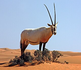
The Arabian oryx or white oryx is a medium-sized antelope with a distinct shoulder bump, long, straight horns, and a tufted tail. It is a bovid, and the smallest member of the genus Oryx, native to desert and steppe areas of the Arabian Peninsula. The Arabian oryx was extinct in the wild by the early 1970s, but was saved in zoos and private reserves, and was reintroduced into the wild starting in 1980.

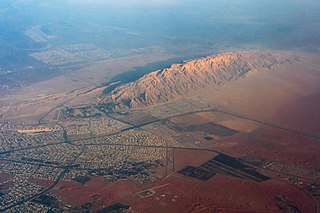
Jabal Hafeet is a mountain in the region of Tawam, on the border of the United Arab Emirates and Oman, which may be considered an outlier of the Hajar Mountains in Eastern Arabia. Due to its proximity to the main Hajar range, the mountain may be considered as being part of the Hajar range. To the north is the UAE city of Al Ain, in the Eastern Region of the Emirate of Abu Dhabi, and the adjacent Omani town of Al-Buraimi.

Duqm is a port town on the coastal strip of the Arabian Sea open to the Indian Ocean. It is about 550 km from Muscat. As of 2017, the population was approximately 12,000.

Ibri is a city and Wilāyat (Province) in the Ad Dhahirah Governorate, in northwest Oman.

Taqah is a wilayat (province) and coastal town of the Dhofar Governorate, in southwestern Oman. It is located at about 17°2′14″N54°24′13″E. The nature of the Taqah wilayat is diverse, as it is a coastal province with beaches, plains, and mountains. It is also known for the presence of caves, such as the caves of Taqah and the caves of Wadi Darbat. Additionally, Taqah has two inlets, Khawr Taqah and Khawr Rawri, both declared as protected areas within the Alkhawr Coastal Nature Reserves by virtue of Royal Decree No. 49/97. The wilayat also features the springs of Ain Khawr Taqah and Ain Darbat, known for their waterfalls."
Adam an administrative region in Ad Dakhiliyah, in northeastern Oman.

Bukhāʾ is a Wilayat and town in the Muhafazah of Musandam in the Sultanate of Oman. It is located in the southwestern side of Musandam, overlooking the Persian Gulf. It is bordered to the east by the Wilayat of Khasab and borders the United Arab Emirates. Its population centers are about 22 localities, including Bukha, Al-Jadi, Ghumda, and Al-Jeri.
Jalan Bani Bu Hassanِ is a wilayah in Ash Sharqiyah South Governorate, Oman. It is bordered by the Al Kamel and Al Wafi Wilayats to the north, Sur Wilayat to the northeast, Badiyah Wilayat and the Al Mudhaibi Wilayat to the west, the Mahoot Wilayat to the southwest, and the Jalan Bani Bu Ali Wilayat and the Arabian Sea to the east. It is approximately 300 kilometers away from the capital, Muscat.

Al Hamra is a 400-year-old town in the region Ad Dakhiliyah, in northeastern Oman. As a province (wilayat), it is home to a number of villages including the mountainside village of Misfat Al Abryeen, with the village of Ghul to the northwest of the town, and Bimah to the north-northeast. The town and province lie on the southern slopes of the Akhdar Mountains.
Manah is a town in the region of Ad Dakhiliyah, in northeastern Oman. As of 2010 it had a population of 7,749.
Al-Mudhaibi is the largest willaya in Ash Sharqiyah region of Oman. It has two niabas: Sinaw and Samad Ash Shan. Suq Sinaw is one of the most popular suqs in Oman. Dresses, khanjars and jewelry are sold there. It includes villages like Al Sudairah, Barzman, and Al Zahib.

The Natural History Museum of Oman is a natural history museum, located at the Ministry of Heritage and Culture complex, Al Khuwair, opposite the Zawawi Mosque in Muscat, Oman.
Dibbā Al-Bayʿah is geographically part of the Dibba region that faces the Arabian Sea, and is bordered by the United Arab Emirates to the south. It is a Wilayat in the Muhafazah of Musandam, Sultanate of Oman, on the east coast of the Arabian Peninsula.It is considered one of the most famous Omani cities known in the pre-Islamic days because it contains Dibba market, which is one of the most famous Arab markets that was known at that time, as merchants from different countries around the world such as India, Sindh and China used to come to it, and some historians, such as Al-Asmai, attribute this name to the locusts Creeping to express the large number of people in it, and the area of that city is approximately 37 km2.

The wildlife of Oman is the flora and fauna of this country in the southeastern corner of the Arabian Peninsula, with coasts on the Gulf of Oman and the Arabian Sea. The climate is hot and dry, apart from the southeastern coast, and the country offers a variety of habitats for wildlife including mountains, valleys, deserts, coastal plains and sea coasts.

Mahout is a wilayat (province) in the Al Wusta Governorate, Oman. It is located in the northeastern part of the Governorate and is bordered to the east by the Arabian Sea and the Wetland Reserve, to the west by the Wilayat of Haima, to the south by the Wilayat of Duqm and to the north by the Wilayat of Adam in the Governorate of A'Dakhiliyah and the Niyabat of Sinaw in the Wilayat of Al Mudhaibi, the center of the Wilayat of Mahout is located in the village of Hijj. 32 villages make up the wilayat, including Hijj, Al Joba, Al Sail, Sirab, Al Najda, Al Khalouf, Mdaira, Sadaira, and others.

The Wilayat of Al-Jazer is located on the central region's coastline strip and is surrounded by states on most sides. It is bounded to the north by the Wilayat of Duqm, to the south by the Wilayat of Shilam, which is one of the states of the Omani Governorate of Dhofar, to the west by the Wilayat of Haima, and to the east by the Arabian Sea.
Muqshin is a wilayat or province of Dhofar Governorate in the Sultanate of Oman. It is located in the northeastern corner of the Dhofar Governorate, on the southeastern outskirts of the Empty Quarter desert, adjacent to the international border with the Kingdom of Saudi Arabia. It is 345 kilometers from the city of Salalah and is connected to the main asphalt road that connects the Dhofar Governorate to the rest of the Sultanate’s regions.


