Hale Duck Decoy

Last updated

One of the pipes of the decoy showing hoops covered with netting and the arrangement of the screens Hale-Duck Decoy 2.jpg
One of the pipes of the decoy showing hoops covered with netting and the arrangement of the screens

Hale Duck Decoy is a duck decoy and nature reserve near the village of Hale, in Halton, Cheshire, England. The site is a Scheduled Ancient Monument and a Site of Special Scientific Interest. It is owned by the Fleetwood-Hesketh Estate and managed by Halton Borough Council together with a group of volunteers.

Contents

History

The precise date of the construction of the duck decoy is not known, but there is evidence that it was built in the 17th century. Records show that in 1754 it was repaired and improved by its owner at that time, Colonel J. Blackburne. [1] The decoy was part of the estate of Hale Hall, which had been owned by the Ireland Blackburne family since the 1600s. In the 1930s the estate was bought by the Fleetwood-Hesketh family, who still own it, but the decoy was allowed to deteriorate. In 1975 restoration of the site began, and it became a local nature reserve. The lease was taken over by Cheshire County Council, who sub-leased it to the Cheshire and Lancashire Conservation Trusts. The site was cleaned up, a swing bridge was built, and trees were planted. The gamekeeper's hut was rebuilt by volunteers in 1981–82. [2]

In February 1990 the decoy was damaged when it was flooded with salt water caused by the combination of a high tide and a north-westerly gale. Trees and other wildlife were killed. [3] Following this, in June and August the central pond was dredged, and in March 1991 the moat was dredged, placing the mud on its banks to increase their height. [4] The lease of the decoy was taken over by Halton Borough Council in 2000, and it was run by their Ranger service. In 2004 a group of volunteers, the Friends of Pickerings Pasture, was awarded a Heritage Lottery grant to restore the gamekeeper's hut to provide further information facilities for visitors. In 2010 the Council disbanded the Ranger service, and the management of the decoy passed to the Parks and Open Spaces department, supported by the Friends of Pickerings Pasture. [1] In December 2013 there was another high tide coinciding with a north-westerly gate, and it was feared that there would be another serious flood. In the event, although the decoy had been breached, there was only minimal flooding and damage. [5]

Description

The reserve covers an area of 3,084 hectares. The decoy consists of a central pond with five narrowing arms (known as pipes) radiating outward, giving it the shape of a pentagon. Between the pipes is woodland, and the whole area is surrounded by a moat 16 feet wide, which is crossed by a swing bridge. [6] Within the site is the restored gamekeeper's hut. This contains display materials and information brochures. Also in the site, near to the area of the boat house is an inscribed stone. The inscription reads "XRC: 63", and it has been suggested that it is a date stone, giving a date of 1633. [1]

Today

The duck decoy is managed by a group of volunteers called The Friends of Pickerings Pasture and Hale Duck Decoy. The site is a designated Scheduled Ancient Monument. [7] The woodland on the site is subject to a Tree Preservation Order, and the site and salt marsh around it is part of the Mersey Estuary Site of Special Scientific Interest. [6] [8] Guided walks for the general public are organised by arrangement with the Friends of Pickerings Pasture. [9] In November 2018 the site was placed on Historic England's Heritage at Risk list and was described as "neglected". [10]

See also

Related Research Articles

<span class="mw-page-title-main">Runcorn</span> Town in England

Runcorn is an industrial town and cargo port in the Borough of Halton, Cheshire, England. Its population in 2021 was 62,100. Runcorn is on the southern bank of the River Mersey, where the estuary narrows to form the Runcorn Gap.

<span class="mw-page-title-main">Romney Marsh</span> Wetland in south-east England

Romney Marsh is a sparsely populated wetland area in the counties of Kent and East Sussex in the south-east of England. It covers about 100 square miles (260 km2). The Marsh has been in use for centuries, though its inhabitants commonly suffered from malaria until the 18th century. Due to its location, geography and isolation, it was a smuggler's paradise between the 1600s and 1800s. The area has long been used for sheep pasture: Romney Marsh sheep are considered one of the most successful and important sheep breeds. Criss-crossed with numerous waterways, and with some areas lying below sea level, the Marsh has over time sustained a gradual level of reclamation, both through natural causes and by human intervention.

<span class="mw-page-title-main">Quarrendon</span> Human settlement in England

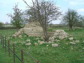
Quarrendon or Quarrendon Leas is a medieval English village near Aylesbury in Buckinghamshire, England, which has been depopulated since the 16th century and is now a scheduled monument.

<span class="mw-page-title-main">Borough of Halton</span> Unitary authority area in Cheshire, England

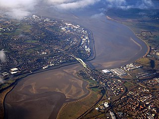
Halton is a unitary authority district with borough status in Cheshire, North West England. It was created in 1974 as a district of the non-metropolitan county of Cheshire, and became a unitary authority area on 1 April 1998 under Halton Borough Council. Since 2014, it has been a member of the Liverpool City Region Combined Authority. The borough consists of the towns of Runcorn and Widnes and the civil parishes of Daresbury, Hale, Halebank, Moore, Preston Brook, and Sandymoor. The district borders Merseyside, the Borough of Warrington and Cheshire West and Chester.

<span class="mw-page-title-main">Decoy</span> Person, device, or event designed as a distraction

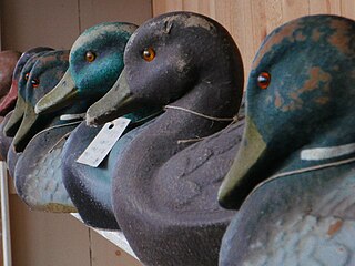
A decoy is usually a person, device, or event which resembles what an individual or a group might be looking for, but it is only meant to lure them. Decoys have been used for centuries most notably in game hunting, but also in wartime and in the committing or resolving of crimes.

<span class="mw-page-title-main">Humboldt Sink</span> Dry lakebed in Nevada, United States

The Humboldt Sink is an intermittent dry lake bed, approximately 11 mi (18 km) long, and 4 mi (6 km) across, in northwestern Nevada in the United States. The body of water in the sink is known as Humboldt Lake. The sink and its surrounding area was a notorious and dreaded portion of overland travel to California during the westward migrations of the mid-1800s, which were largely undertaken along the California Trail.

<span class="mw-page-title-main">River Ribble</span> River in North Yorkshire and Lancashire, England

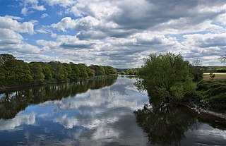
The River Ribble runs through North Yorkshire and Lancashire in Northern England. It starts close to the Ribblehead Viaduct in North Yorkshire, and is one of the few that start in the Yorkshire Dales and flow westwards towards the Irish Sea.

<span class="mw-page-title-main">Vale of Pickering</span> Low-lying plain in North Yorkshire, England

The Vale of Pickering is a low-lying flat area of land in North Yorkshire, England. It is drained by the River Derwent. The landscape is rural with scattered villages and small market towns. It has been inhabited continuously from the Mesolithic period. The present economy is largely agricultural with light industry and tourism playing an increasing role.

<span class="mw-page-title-main">Hale, Halton</span> Human settlement in England

Hale is a village and civil parish in the Borough of Halton, Cheshire, England with a population of 1,800. The village is north of the River Mersey, and just to the east of the boundary with Merseyside. It is 3 miles east of Speke in Liverpool, and 4 miles south-west of Widnes. The nearby village of Halebank is to the north-east.

<span class="mw-page-title-main">Westhay Moor</span> Site of Special Scientific Interest

Westhay Moor is a 513.7-hectare (1,269-acre) biological Site of Special Scientific Interest 2.5 kilometres (1.6 mi) north-east of Westhay village and 4 kilometres (2.5 mi) from Wedmore in Somerset, England, notified in 1971. Westhay Moor is also notified as part of the Somerset Levels and Moors Special Protection Area under the EU Birds Directive and as a Ramsar site, and a National Nature Reserve.

<span class="mw-page-title-main">Widnes</span> Town in Cheshire, England

Widnes is an industrial town in the Borough of Halton, Cheshire, England, which at the 2021 census had a population of 62,400.

<span class="mw-page-title-main">Duck decoy (structure)</span> Device to capture wild ducks or other species of waterfowl

A duck decoy is a device to capture wild ducks or other species of waterfowl. Decoys had an advantage over hunting ducks with shotguns as the duck meat did not contain lead shot. Consequently, a higher price could be charged for it.

<span class="mw-page-title-main">Moat Mount Open Space</span> Park and nature reserve in London

Moat Mount Open Space is a 110-hectare park and nature reserve in Mill Hill in the London Borough of Barnet. It is part of Moat Mount Open Space and Mote End Farm Site of Borough Importance for Nature Conservation, Grade II, which includes Barnet Gate Wood and Scratchwood Countryside Park, but is separate from Scratchwood itself, which is a neighbouring park and nature reserve. Most of the site is open to the public, but Mote End Farm and some other areas are private. Scratchwood and Moat Mount are a Local Nature Reserve.

<span class="mw-page-title-main">Halton Borough Council</span>

Halton Borough Council is the local authority for the Borough of Halton, incorporating the towns of Runcorn and Widnes and the parishes of Daresbury, Hale, Moore and Preston Brook. It is a constituent council of Liverpool City Region Combined Authority.

<span class="mw-page-title-main">Sound Heath</span>

Sound Heath, also known as Sound Common, is an area of common land in Sound, near Nantwich in Cheshire, England, which includes heathland, grassland, scrub, woodland and wetland habitats. The majority of the area is designated a Site of Special Scientific Interest and a Local Nature Reserve.

<span class="mw-page-title-main">Potteric Carr</span>

Potteric Carr is a large area of land to the southeast of Doncaster, in Yorkshire, England, over 3,000 acres (12 km2) in size.

<span class="mw-page-title-main">Charles E. Wheeler Wildlife Management Area</span>

Charles E. Wheeler Wildlife Management Area is a 625-acre (253 ha) brackish tidal marsh, nature preserve and hunting area owned by the state of Connecticut located in Devon (village), Milford, New Haven County, Connecticut.

References

  1. 1 2 3 "History of Hale Duck Decoy". Friends of Pickerings Pasture. Retrieved 25 June 2014.
  2. "The Restoration of Hale Duck Decoy". Friends of Pickerings Pasture. Retrieved 25 June 2014.
  3. "The Flood". Friends of Pickerings Pasture. Retrieved 25 June 2014.
  4. "Dredging the pond and moat". Friends of Pickerings Pasture. Retrieved 25 June 2014.
  5. "Tidal surge and flooding on Hale Marsh and Hale Duck Decoy". Friends of Pickerings Pasture. Retrieved 25 June 2014.
  6. 1 2 "About Hale Duck Decoy". Friends of Pickerings Pasture. Retrieved 25 June 2014.
  7. Historic England. "Duck decoy pond 200m south east of Marsh Bridge, Hale, Halton (1014717)". National Heritage List for England . Retrieved 25 June 2014.
  8. Natural England (1985). "Mersey Estuary (SSSI citation)" (PDF). Retrieved 4 January 2022.
  9. "Hale Duck Decoy NR Guided Walks". Friends of Pickerings Pasture. Retrieved 25 June 2014.
  10. "'Neglected' duck decoy pond placed on Heritage at Risk list". BBC News. 8 November 2018. Retrieved 4 January 2022.

53°20′19″N2°47′07″W / 53.3385°N 2.7854°W / 53.3385; -2.7854