The old Barony and castle of Corsehill lay within the feudal Baillerie of Cunninghame, near Stewarton, now East Ayrshire, Scotland.
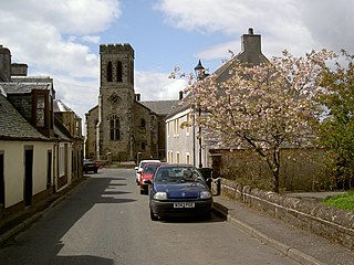
Dunlop is a village and parish in East Ayrshire, Scotland. It lies on the A735, north-east of Stewarton, seven miles from Kilmarnock. The road runs on to Lugton and the B706 enters the village from Beith and Burnhouse.

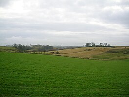
Lugton is a small village or hamlet in East Ayrshire, Scotland with a population of 80 people. The A736 road runs through on its way from Glasgow, 15 miles (24.1 km) to the north, to Irvine in North Ayrshire. Uplawmoor is the first settlement on this 'Lochlibo Road' to the north and Burnhouse is to the south. The settlement lies on the Lugton Water which forms the boundary between East Ayrshire and East Renfrewshire as well as that of the parishes of Dunlop and Beith.
Hessilhead is in Beith, North Ayrshire, Scotland. Hessilhead used to be called Hazlehead or Hasslehead. The lands were part of the Lordship of Giffen, and the Barony of Hessilhead, within the Baillerie of Cunninghame and the Parish of Beith. The castle was situated at grid reference NS380532.
The hamlet of Auchentiber is in North Ayrshire, Parish of Kilwinning, Scotland. Auchentiber is four miles northeast of Kilwinning on the Lochlibo Road, 2+1⁄4 mi (3.5 km) from the hamlet of Burnhouse and 2+1⁄2 mi (4 km) from the village of Barrmill. Grid Ref. NS3647. Some new housing has been built, but the settlement is still very much a hamlet. The settlement is on the Lugton Water, which runs into the River Garnock after running through Montgreenan and Eglinton Country Park in Irvine.

The Barony of Giffen and its associated 15th-century castle were in the parish of Beith in the former District of Cunninghame, now North Ayrshire. The site may be spelled Giffen or Giffin and lay within the Lordship of Giffin, which included the Baronies of Giffen, Trearne, Hessilhead, Broadstone, Roughwood and Ramshead; valued at £3,788 9s 10d. The Barony of Giffen comprised a number of properties, including Greenhills, Thirdpart, Drumbuie, Nettlehirst and Balgray, covering about half of the parish of Beith. Giffen was a hundred merk land, separated from the Barony of Beith, a forty-pound land, by the Powgree Burn which rises on Cuff hill. The Lugton Water or the Bungle Burn running through Burnhouse may have been the Giffen barony boundary with that of the adjacent barony and lands of Aiket castle.

The Lugton Water, the largest tributary of the River Garnock, runs 14 miles (23 km) from Loch Libo in Uplawmoor, through Lugton and the parishes of Neilston, Beith, Dunlop, Stewarton and Kilwinning. The Lugton joins the Garnock below the tidal limit, shortly after passing through Eglinton Country Park, developed around the ancient estate of the Earl of Eglinton.
Fergushill is a small community in North Ayrshire, Parish of Kilwinning, Scotland. The Barony of Fergushill was held by the Fergushill family of that Ilk and the area has a complex history.

Baron of Aiket (extinct) was a title of nobility in the Baronage of Scotland for the holder of the Barony of Aiket with its castle, lay within the old feudal bailiary of Cunninghame. The barony lands equate to the extant Parish of Dunlop, East Ayrshire, Scotland.
Caldwell is a mansion and old estate with the remains of a castle nearby. These lands lie close to the Lugton Water and the villages of Uplawmoor in East Renfrewshire and Lugton in East Ayrshire.

Busbie Castle was situated in what is now known as Knockentiber, a village in East Ayrshire, Parish of Kilmaurs, Scotland. Knockentiber is 2 miles (3.2 km) WNW of Kilmarnock and 1/2 mile NE of Crosshouse. The castle overlooked the Carmel Glen and its Burn, which runs into the River Irvine, a mile or so to the south, after passing through the old Busbie Mill.

Kennox House is situated on Kilwinning Road between Stewarton to Torranyard in North Ayrshire, Parish of Dunlop, Scotland. The house overlooks the Glazert Burn, which runs into the Annick Water at Watermeetings.

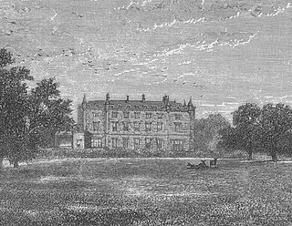
The Lands of Lainshaw lie in Strathannick and were part of the Lordship of Stewarton, in East Ayrshire, Scotland. Lainshaw House is a category B listed mansion, lying in a prominent position above the Annick Water and its holm in the Parish of Stewarton, Scotland. Part of the much older Lainshaw Castle is contained within the several later building phases of the present day Lainshaw House. The names 'Langshaw' or 'Langschaw' were used in historic times. Law Mount near the High and Laigh Castleton farms has been suggested as the site of the original castle, granted in the 12th century to Godfrey de Ross by Hugo de Morville.
The old Barony and castle, fortalice, or tower house of Hill of Beith lay in the feudal Regality of Kilwinning, within the Baillerie of Cunninghame, and the Sherrifdom of Ayr, now the Parish of Beith, North Ayrshire, Scotland.

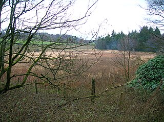
Loch Brand or Loch of Boghall was a loch situated in a depression between the Grange Estate, Crummock, Hill of Beith Castle site and Boghall in the Parish of Beith, North Ayrshire, Scotland. The loch was fed by the Grange Burn and surface runoff, such as from the old rig and furrows indicated by Roy's Maps of the mid 17th century. The loch was drained by the Boghall Burn that runs passed the 'Court Hill' and into Powgree Burn at Gateside.

Lambroughton Loch or Wheatrig Loch was situated in a low-lying area between the farms and dwellings of Hillhead, Lambroughton, Wheatrig, Titwood and Lochridge mainly in the Parish of Dreghorn, North Ayrshire. The loch was mainly fed by the Lochridge Burn, the Garrier Burn and surface runoff, such as from the old rig and furrows indicated by Roy's maps of the mid-18th century. The loch outflow was via the Lochridge Burn that runs into the Garrier Burn, passes the site of the old Lochend habitation and into the Bracken Burn near Little Alton. The rivulet or watercourse is known as the Garrier Burn beyond this point.
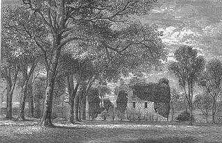
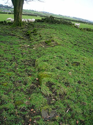
Hessilhead Loch or Hazelhead Loch was situated in a low-lying area near the old Castle of Hessilhead in the Parish of Beith, North Ayrshire, Scotland. The old loch, used in the defence of the castle, was probably infilled when the castle ruins were landscaped in the 19th century.
The Lands of Doura, Dawra, Dawray, DowreyDowray, Dourey or Douray formed a small estate, at one time part of the Barony of Corsehill and Doura, situated near the Eglinton Estate in the Parish of Kilwinning, North Ayrshire, Scotland.

The Lands of Borland formed an estate lying between Aiket Castle and the town of Dunlop, East Ayrshire, Parish of Dunlop, Scotland. The laird's house at Borland stood near the Sandy Ford over the Glazert Water. The names Bordland, Boreland, Borland, Laigh Borland, Low Borland and Nether Borland have all been applied to the site of the laird's house.

The Lands of Templehouse formed a small estate lying between Aiket Castle and the town of Dunlop, East Ayrshire, Parish of Dunlop, Scotland. The laird's house at Templeland of Dunlop Hill, to give it its formal name, stood near to the ancient road leading from Dunlop to Kirkwood and on to Kennox. The lands were held by the Knights Templar until a date prior to 1570 when the Gemmells of Templehouse were granted the property and remained there until 1962, a period of around 500 years. The spelling 'Gemmell' is used for consistency except where otherwise denoted.