Hall Natural Area

Last updated

The Hall Natural Area or Harvey Monroe Hall Natural Area is a region on the eastern border of Yosemite National Park in California. The area is located about 1.25 miles (2.0 km) northwest of Tioga Pass, and is approximately four miles (6.4 km) long from north to south and 2.75 miles (4.4 km) wide at its widest point. It lies completely within the Inyo National Forest. [1]

Yosemite National Park National park in California, United States

Yosemite National Park is an American national park located in the western Sierra Nevada of Central California, bounded on the southeast by Sierra National Forest and on the northwest by Stanislaus National Forest. The park is managed by the National Park Service and covers an area of 747,956 acres and sits in four counties: centered in Tuolumne and Mariposa, extending north and east to Mono and south to Madera County. Designated a World Heritage site in 1984, Yosemite is internationally recognized for its granite cliffs, waterfalls, clear streams, giant sequoia groves, lakes, mountains, meadows, glaciers, and biological diversity. Almost 95% of the park is designated wilderness.

California State of the United States of America

California is a state in the Pacific Region of the United States. With 39.6 million residents, California is the most populous U.S. state and the third-largest by area. The state capital is Sacramento. The Greater Los Angeles Area and the San Francisco Bay Area are the nation's second and fifth most populous urban regions, with 18.7 million and 9.7 million residents respectively. Los Angeles is California's most populous city, and the country's second most populous, after New York City. California also has the nation's most populous county, Los Angeles County, and its largest county by area, San Bernardino County. The City and County of San Francisco is both the country's second-most densely populated major city after New York City and the fifth-most densely populated county, behind only four of the five New York City boroughs.

Tioga Pass mountain pass in the Sierra Nevada mountains of California, United States

Tioga Pass is a mountain pass in the Sierra Nevada mountains of California. State Route 120 runs through it, and serves as the eastern entry point for Yosemite National Park, at the Tioga Pass Entrance Station. It is the highest highway pass in California and in the Sierra Nevada. Mount Dana is to the east of the pass. There are several trailheads into the Yosemite backcountry which begin at Tioga Pass, including the trail to the Gaylor Lakes to the west/northwest, and the rough trail to the summit of Mount Dana. Dana Meadows is immediately south of the pass alongside the highway, as the pass itself is roughly angled north/south as opposed to east/west. Dana Meadows contains several small lakes.

Contents

Geography

A view of the Hall Natural Area, with Mount Conness under the arrow. Mt Casson Pano 4wiki.jpg
A view of the Hall Natural Area, with Mount Conness under the arrow.

The Natural Area covers 3,883 acres (1,571 ha). Elevations range from 9,600 feet (2,900 m) along Lee Vining Creek to 12,590 feet (3,840 m) atop Mount Conness. The entire area is drained by Lee Vining Creek, which flows from northwest to southeast. Glaciation strongly affected the topography. Several deeply glaciated northeast-facing cirques are present, with steep headwalls and flats or lakes at their floors. Much of the lower elevation area is stepped topography resulting from differential erosion along jointing planes in the granitic bedrock. [1]

Lee Vining Creek

Lee Vining Creek is a 16.2-mile-long (26.1 km) stream in Mono County, California, flowing into the endorheic basin of Mono Lake. It is the second largest stream flowing into the lake, after Rush Creek.

Mount Conness mountain in United States of America

Mount Conness is a 12,590 foot (3,840 m) mountain in the Sierra Nevada range, to the west of the Hall Natural Area. Conness is on the boundary between the Inyo National Forest and Yosemite National Park. The Conness Glacier lies north of the summit.

Granite A common type of intrusive, felsic, igneous rock with granular structure

Granite is a common type of felsic intrusive igneous rock that is granular and phaneritic in texture. Granites can be predominantly white, pink, or gray in color, depending on their mineralogy. The word "granite" comes from the Latin granum, a grain, in reference to the coarse-grained structure of such a holocrystalline rock. Strictly speaking, granite is an igneous rock with between 20% and 60% quartz by volume, and at least 35% of the total feldspar consisting of alkali feldspar, although commonly the term "granite" is used to refer to a wider range of coarse-grained igneous rocks containing quartz and feldspar.

The climate is high Sierran montane with copious winter snowfall. Average annual precipitation is estimated to be more than 25 inches (640 mm). There is great variation in temperature and growing season. [1]

History and purpose

The Research Natural Area (RNA) program is a nationwide system created to protect a network of federally administered public lands for the primary purposes of maintaining biological diversity, providing baseline ecological information, and encouraging research and university natural history education. In California, the RNA program is administered jointly by the USDA Forest Service Pacific Southwest Research Station and Pacific Southwest Region [2]

Research Natural Area federal ecological reserve of the United States

Research Natural Area is a designation for certain protected areas in the United States.

Ecology Scientific study of the relationships between living organisms and their environment

Ecology is the branch of biology which studies the interactions among organisms and their environment. Objects of study include interactions of organisms that include biotic and abiotic components of their environment. Topics of interest include the biodiversity, distribution, biomass, and populations of organisms, as well as cooperation and competition within and between species. Ecosystems are dynamically interacting systems of organisms, the communities they make up, and the non-living components of their environment. Ecosystem processes, such as primary production, pedogenesis, nutrient cycling, and niche construction, regulate the flux of energy and matter through an environment. These processes are sustained by organisms with specific life history traits. Biodiversity means the varieties of species, genes, and ecosystems, enhances certain ecosystem services.

Natural history study of organisms including plants or animals in their environment

Natural history is a domain of inquiry involving organisms including animals, fungi and plants in their environment; leaning more towards observational than experimental methods of study. A person who studies natural history is called a naturalist or natural historian.

The Hall Natural Area was one of the first established in California (in 1933). The Carnegie Institution of Washington’s studies on genotype-environment interactions made much use of the transplant gardens at the south end of the Natural Area. Since then, other researchers have used the area, studying social organization of Belding ground squirrels, dynamics of wind-blown detritus in snow banks, and community structuring of subalpine forest birds. [1]

Genotype classification system used to categorize organisms based on their genetic characteristics; organisms full hereditary information, part (DNA sequence) of the genetic makeup of a cell, one of three factors that determine phenotype

The genotype is the part of the genetic makeup of a cell, and therefore of any individual, which determines one of its characteristics (phenotype). The term was coined by the Danish botanist, plant physiologist and geneticist Wilhelm Johannsen in 1903.

Detritus Dead particulate organic material

In biology, detritus is dead particulate organic material. It typically includes the bodies or fragments of dead organisms as well as fecal material. Detritus is typically colonized by communities of microorganisms which act to decompose the material. In terrestrial ecosystems, it is encountered as leaf litter and other organic matter intermixed with soil, which is denominated "soil organic matter". Detritus of aquatic ecosystems is organic material suspended in water and piling up on seabed floors, which is referred to as marine snow.

Snow precipitation in the form of flakes of crystalline water ice

Snow refers to forms of ice crystals that precipitate from the atmosphere and undergo changes on the Earth's surface. It pertains to frozen crystalline water throughout its life cycle, starting when, under suitable conditions, the ice crystals form in the atmosphere, increase to millimeter size, precipitate and accumulate on surfaces, then metamorphose in place, and ultimately melt, slide or sublimate away. Snowstorms organize and develop by feeding on sources of atmospheric moisture and cold air. Snowflakes nucleate around particles in the atmosphere by attracting supercooled water droplets, which freeze in hexagonal-shaped crystals. Snowflakes take on a variety of shapes, basic among these are platelets, needles, columns and rime. As snow accumulates into a snowpack, it may blow into drifts. Over time, accumulated snow metamorphoses, by sintering, sublimation and freeze-thaw. Where the climate is cold enough for year-to-year accumulation, a glacier may form. Otherwise, snow typically melts seasonally, causing runoff into streams and rivers and recharging groundwater.

Related Research Articles

Monroe County, Tennessee County in the United States

Monroe County is a county located in the U.S. state of Tennessee. As of the 2010 census, the population was 44,519. Its county seat is Madisonville.

Mendocino National Forest

The Mendocino National Forest is located in the Coastal Mountain Range in northwestern California and comprises 913,306 acres (3,696 km2). It is the only national forest in the state of California without a major paved road entering it. There are a variety of recreational opportunities — camping, hiking, mountain biking, paragliding, backpacking, boating, fishing, hunting, nature study, photography, and off-highway vehicle travel.

William O. Douglas Wilderness

The William O. Douglas Wilderness is a designated wilderness in the central portion of the state of Washington. It includes 169,081 acres (68,425 ha) located between the U.S. Route 12 and State Route 410 and is jointly administered by the Okanogan-Wenatchee National Forest and the Gifford Pinchot National Forest. It shares a boundary with the Mt. Rainier National Park on the west; Norse Peak Wilderness lies to the north, Goat Rocks Wilderness to the south. Approximately 25 miles (40 km) of the Pacific Crest Trail travel along the Cascade Range crest within its boundaries. It contains scattered peaks, sharp ridges, steep slopes and hundreds of small lakes and potholes. Much of the wilderness is drained by tributaries of the Naches River.

Bowman Creek river in United States of America

Bowman Creek is a tributary of the Susquehanna River in Luzerne County and Wyoming County, in Pennsylvania, in the United States. It is approximately 26 miles (42 km) long and flows through Ross Township and Lake Township in Luzerne County and Noxen Township, Monroe Township, and Eaton Township in Wyoming County. The watershed of the creek has an area of 120 square miles (310 km2). The creek is not designated as an impaired waterbody and its pH is close to neutral, although it has experienced some problems with acid rain. It has low concentrations of dissolved solids like calcium. The creek is relatively small in its upper reaches, but by Noxen, its width is 40 to 60 feet. It is also relatively shallow in many reaches. Rock formations in the watershed include the Catskill Formation, the Huntley Mountain Formation, Burgoon Sandstone, the Mauch Chunk Formation, the Pottsville Group, and the Pocono Formation. Soil associations in the creek's watershed include the Wellsboro-Morris-Oquaga association, the Oquaga-Lackawanna-Arnot association, the Mardin-Bath-Volusia association, and the Wyoming-Pope association.

Harveys Creek tributary of the Susquehanna River in Pennsylvania

Harveys Creek is a tributary of the Susquehanna River in Luzerne County, Pennsylvania, in the United States. It is approximately 14.5 miles (23.3 km) long and flows through Harveys Lake, Lake Township, Lehman Township, Jackson Township, and Plymouth Township. The creek's watershed has an area of 46.3 square miles (120 km2). The creek has four named tributaries, which are known as Bear Hollow Creek, Paint Spring Run, Pikes Creek, and East Fork Harveys Creek. The watershed is designated as a High-Quality Coldwater Fishery and a Migratory Fishery above Pikes Creek and as a Coldwater Fishery and a Migratory Fishery below it. The creek's source is Harveys Lake, the largest natural lake in Pennsylvania.

Meshoppen Creek is a tributary of the Susquehanna River in Susquehanna and Wyoming counties, Pennsylvania, in the United States. It is approximately 30.6 miles (49.2 km) long and flows through Bridgewater Township, Dimock Township, and Springville Township in Susquehanna County and Lemon Township, Washington Township, Meshoppen Township, and Meshoppen in Wyoming County. The watershed of the creek has an area of 114 square miles (300 km2). It is possible to canoe on 17.0 miles (27.4 km) of Meshoppen Creek.

Cherry Creek (Tuolumne River tributary)

Cherry Creek is a large, swift-flowing stream in the Sierra Nevada mountain range, and is the largest tributary of the Tuolumne River. The creek is 40 miles (64 km) long measured to its farthest headwaters; the main stem itself is 26 miles (42 km) long, draining a watershed of 234 square miles (610 km2) in the Stanislaus National Forest. Part of the drainage also extends into the northwest corner of Yosemite National Park.

Mercey Hot Springs, California Unincorporated community in California, United States

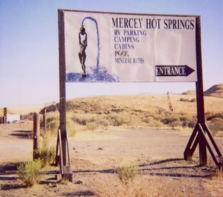
Mercey Hot Springs is an unincorporated community in the Little Panoche Valley of Fresno County, central California, about 60 miles (97 km) west-southwest of Fresno. It is a resort along South Fork Little Panoche Creek and the Little Panoche Road located at the western edge of Fresno County.

South Branch Towanda Creek is a tributary of Towanda Creek in Bradford County, Pennsylvania, in the United States. It is approximately 16.5 miles (26.6 km) long and flows through Terry Township, Albany Township, New Albany, and Monroe Township.

Indian Creek Township, Pulaski County, Indiana Township in Indiana, United States

Indian Creek Township is one of twelve townships in Pulaski County, Indiana, United States. As of the 2010 census, its population was 691 and it contained 422 housing units.

Mount Eddy mountain in United States of America

Mount Eddy is the highest peak of the Trinity Mountains, a mountain range of the Klamath Mountains System, located in Siskiyou County, and Trinity County in northern California.

Rasor Off-Highway Vehicle Area is a remote public use area for the off-highway vehicle user located in the Mojave Desert about 50 miles (80 km) east of Barstow, California, administered by the Bureau of Land Management.

Cascades (ecoregion)

The Cascades ecoregion is a Level III ecoregion designated by the United States Environmental Protection Agency (EPA) in the U.S. states of Washington, Oregon, and California. Somewhat smaller than the Cascade mountain range for which it is named, the ecoregion extends north to Snoqualmie Pass, near Seattle, and south to Hayden Pass, near the Oregon-California border, including the peaks and western slopes of most of the High Cascades. A discontiguous section is located on Mount Shasta in California.

Trout Creek Hill mountain in United States of America

Trout Creek Hill is a small Pleistocene basaltic shield volcano in Washington, United States. Located in Skamania County, Trout Creek Hill rises to an elevation of 2,946 feet (898 m). It is part of the Cascade Volcanic Arc, located in the Marble Mountain-Trout Creek Hill volcanic field.

Bucks Lake Wilderness

The Bucks Lake Wilderness is a 23,958-acre (97.0 km2) wilderness area located in the Plumas National Forest section of the Sierra Nevada, in northeastern California, United States.

Mono Basin National Scenic Area

The Mono Basin National Forest Scenic Area is a protected area in Eastern California that surrounds Mono Lake and the northern half of the Mono Craters volcanic field. It is administered by the Inyo National Forest as a unit of the National Forest Scenic Area program, under the U.S. Forest Service.

South Fork Eel River Wilderness

The South Fork Eel River Wilderness is a 12,868-acre (5,207 ha) wilderness area located in Mendocino County, California. The wilderness was added to the National Wilderness Preservation System when the United States Congress passed the Northern California Coastal Wild Heritage Wilderness Act in 2006. The Department of the Interior's Bureau of Land Management (BLM) is the agency in charge.

Crabtree Hot Springs, California Place in California, United States

Crabtree Hot Springs is a geological phenomenon in Lake County, California about 25 miles (40 km) north of Upper Lake. It is located on private property and closed to the public. It lies at an elevation of 2,257 feet. There is a cluster of four natural hot springs at this location, in an isolated narrow winding steep walled canyon on the north bank of the Rice Fork of the Eel River, about one fourth mile downriver from its junction with Salt Creek. Three of the hot springs are aligned in one area at a large swimming hole, while the fourth hot spring is about 60 feet back upriver. The temperature of the hottest spring is 106 °F (41 °C), with a flow rate of about 10 US gallons (38 L) per minute.

Rice Fork in California, United States

The Rice Fork is a 22.7-mile-long (36.5 km) tributary of the Eel River in Lake County, California. The Rice Fork begins on the upper northwest side of Goat Mountain, on the Colusa-Lake County line, at an elevation of over 6,000 feet (1,800 m). It quickly descends the steep western slope of the mountain, then bends northward, and flows northwesterly down a narrow winding steep walled canyon for about 18 miles (29 km), crossing two forest roads and adding many tributaries, ending its journey at the southern tip of Lake Pillsbury, at a varied elevation around 1,800 feet (550 m), depending on the lake level. Before the construction of Scott Dam in the 1920s, which formed Lake Pillsbury, the Rice Fork ran directly into the Eel River. It is one of Lake County's longest streams.

Redwood Experimental Forest experimental forest in Del Norte County, California, USA

The Redwood Experimental Forest is an experimental forest in Del Norte County, California. The forest is near the mouth of the Klamath River in the California Coast Ranges of Northern California. The 379 hectares forest is drained by High Prairie Creek. As its name implies, the principal species in the forest is coast redwood , but the site also contains Douglas fir, Sitka spruce, western hemlock, and Port Orford cedar. The forest is managed by the United States Forest Service. Tree ages range up to 1,200 years. Topography varies considerably over the forest. Slopes range from 0 to over 75 percent, and elevation ranges from 40 to 340 m (130–1,120 ft).

References

Coordinates: 37°57′29″N119°17′46″W / 37.958°N 119.296°W / 37.958; -119.296

Geographic coordinate system Coordinate system

A geographic coordinate system is a coordinate system that enables every location on Earth to be specified by a set of numbers, letters or symbols. The coordinates are often chosen such that one of the numbers represents a vertical position and two or three of the numbers represent a horizontal position; alternatively, a geographic position may be expressed in a combined three-dimensional Cartesian vector. A common choice of coordinates is latitude, longitude and elevation. To specify a location on a plane requires a map projection.