Christchurch is the largest city in the South Island and the second-largest city by urban area population in New Zealand. Christchurch has an urban population of 415,100, and a metropolitan population of over half a million. It is located in the Canterbury Region, near the centre of the east coast of the South Island, east of the Canterbury Plains. It is located near the southern end of Pegasus Bay, and is bounded to the east by the Pacific Ocean and to the south by the ancient volcanic complex of the Banks Peninsula. The Avon River (Ōtākaro) winds through the centre of the city, with a large urban park along its banks. With the exception of the Port Hills, it is a relatively flat city, on an average around 20 m (66 ft) above sea level. Christchurch has a reputation for being an English city, with its architectural identity and nickname the 'Garden City' due to similarities with garden cities in England, but also has a historic Māori heritage. Christchurch has a temperate oceanic climate with regular moderate rainfall.
Riccarton is a suburb of Christchurch. It is due west of the city centre, separated from it by Hagley Park. Upper Riccarton is to the west of Riccarton.

Cashmere is a suburb which rises above the southern end of the city of Christchurch in New Zealand's South Island, on the north side of the Port Hills. It covers an area of 4.71 km2 (1.82 sq mi) and has a population of 6,453 as at 2018.
Originally a separate village, Halswell is now a residential suburb of Christchurch, New Zealand, located 9 kilometres (5.6 mi) southwest of Cathedral Square on State Highway 75.

Wigram is a suburb in the southwest of Christchurch, New Zealand. The suburb lies close to the industrial estates of Sockburn and the satellite retail and residential zone of Hornby, and has undergone significant growth in recent years due to housing developments. It is seven kilometres to the west of the city centre.

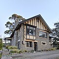
The Sign of the Takahe is a neo-Gothic style historic building in Christchurch, New Zealand. It is currently leased from Christchurch City Council and run as a cafe, bar, and wedding and function venue.

William Rolleston was a New Zealand politician, public administrator, educationalist and Canterbury provincial superintendent.

Henry George Ell, commonly known as Harry Ell, was a Christchurch City councillor and a New Zealand Member of Parliament. He is famous for his conservation work around Christchurch's Port Hills, his advocacy for the Summit Road, and his construction of the Sign of the Takahe and other road houses along the Summit Road.

The Christchurch City Council (CCC) is the local government authority for Christchurch in New Zealand. It is a territorial authority elected to represent the 415,100 people of Christchurch. Since October 2022, the Mayor of Christchurch is Phil Mauger, who succeeded after the retirement of Lianne Dalziel. The council currently consists of 16 councillors elected from sixteen wards, and is presided over by the mayor, who is elected at large. The number of elected members and ward boundaries changed prior to the 2016 election.

John Ollivier was a Member of Parliament in New Zealand, but was better known for his membership of the Canterbury Provincial Council. He was the second chairman of the Christchurch Town Council.
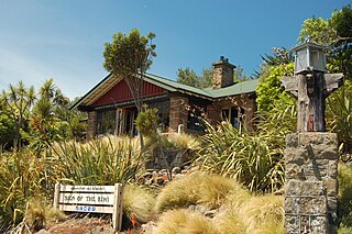
The Sign of the Kiwi, originally called Toll House, is a small café and shop at Dyers Pass on the road between Christchurch and Governors Bay. It was built in 1916–17 by Harry Ell as a staging post and opened as a tearoom and rest house. It has a Category I heritage classification by Heritage New Zealand and is a popular destination for tourists and locals alike. The building was closed some time after the 22 February 2011 Christchurch earthquake and did not open again until 23 January 2017, six years later. Although located within the burned area, the building was not damaged by the 2017 Port Hills fires a month later.
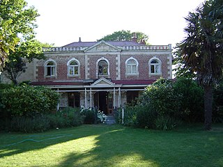
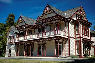
Linwood House was built as the homestead for Joseph Brittan, who, as surgeon, newspaper editor and provincial councillor, was one of the dominant figures in early Christchurch, New Zealand. The suburb of Linwood was named after Brittan's farm and homestead. Brittan's daughter Mary married William Rolleston, and they lived at Linwood House following Joseph Brittan's death. During that time, Rolleston was the 4th Superintendent of the Canterbury Province, and Linwood House served for many important political and public functions.

Aidanfield is a suburb in the south-west of Christchurch, New Zealand, about 8 kilometres (5.0 mi) from the city centre. The land, which had been owned by the Good Shepherd Sisters since 1886, now incorporates the Mount Magdala Institute and the St John of God Chapel, which has a Category I heritage listing by the New Zealand Historic Places Trust. The first residents moved into the suburb in 2002. The developer caused controversy in 2007–2008 by applying to have a group of farm buildings demolished to allow for further subdivision. Christchurch City Council was widely criticised for approving the demolition despite the buildings having had a heritage listing in the Christchurch City Plan.

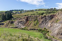
Ōrongomai / Cass Peak is a hill in the western Port Hills in Christchurch, New Zealand. Its most notable feature is a radar dome that was built on the peak in the late 1980s, which is used for aircraft positioning services.
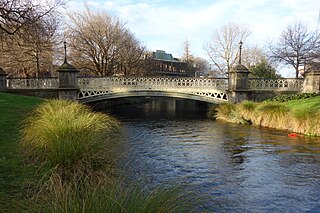
Hamish Hay Bridge is a bridge located in Victoria Square, Christchurch, New Zealand. Built in 1864, it was renamed in 1989 for Sir Hamish Hay, Mayor of Christchurch; a commemorative bronze plaque is affixed to the bridge's guard rail in the middle of the structure to honor Hay's services. The bridge, the oldest heritage feature in the square, is also the country's oldest cast iron and stone bridge. It survived the 2011 earthquake undamaged. Architectural features include the bridge arch and the balustrade's neo-gothic ornamentation. The bridge is registered as a Category II heritage structure with the New Zealand Historic Places Trust.

Kennedys Bush is a south-western suburb of Christchurch, New Zealand.

Cracroft Reserve is a 3.2-hectare (7.9-acre) public reserve on Cracroft Hill in the Cashmere suburb of Christchurch, New Zealand. It is situated next to the Sign of the Takahe. Cracroft Reserve is a popular stop for tourists, and residents, with its viewing platform at 200 metres (660 ft) elevation providing panoramic views of Christchurch city, the Canterbury Plains, and the Southern Alps. The main entrance to the reserve is from the southern end of Hackthorne Road.
Lansdowne, also spelled Lansdown, is a locality south of Christchurch, New Zealand.
Kennedy's Bush Scenic Reserve is a public conservation reserve in the Port Hills south of Christchurch, New Zealand. It sits above the suburb of Kennedys Bush on the northern side of the hills, just north of Ōrongomai / Cass Peak. The reserve is covered in dense native bush, and at 130 hectares it is the largest remaining patch of native bush on the Port Hills.