Leeuwin-Naturaliste National Park is a national park in the South West region of Western Australia, 267 km (166 mi) south of Perth. It is named after the two locations at either end of the park which have lighthouses, Cape Leeuwin and Cape Naturaliste. It is located in the Augusta-Margaret River and Busselton council areas, and is claimed to have the highest visiting numbers of any national park in Western Australia. The park received 2.33 million visitors through 2008–2009.

Cape Leeuwin is the most south-westerly mainland point of the Australian continent, in the state of Western Australia.

Augusta is a town on the south-west coast of Western Australia, where the Blackwood River flows into Flinders Bay. It is the nearest town to Cape Leeuwin, on the furthest southwest corner of the Australian continent. In the 2001 census it had a population of 1,091; by 2016 the population of the town was 1,109.

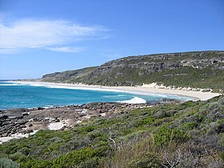
Hamelin Bay is a bay and a locality on the southwest coast of Western Australia between Cape Leeuwin and Cape Naturaliste. It is named after French explorer Jacques Félix Emmanuel Hamelin, who sailed through the area in about 1801. It is south of Cape Freycinet.
Maurice Coleman Davies was an Australian timber merchant and pastoralist. Born in London, he emigrated to Tasmania with his family as a child, and later moved to Blackwood in the Victorian goldfields, then to Melbourne and Adelaide. He then relocated to Western Australia, where he created the M. C. Davies Company, later the M. C. Davies Karri and Jarrah Timber Company, a timber empire that employed hundreds of men, laid over a hundred kilometres of private railway, including the Flinders Bay Branch Railway, and even built its own private ports for exporting of timber. He also formed the Kimberley Pastoral Company and was its managing director.
St Alouarn Islands are a group of islands and rocks south-east of Cape Leeuwin in Western Australia, approximately 11 km south of Augusta in Flinders Bay.

Yallingup is a town in the South West region of Western Australia, 256 kilometres (159 mi) south of Perth. Yallingup is a popular tourist destination because of its beaches and limestone caves, and proximity to Leeuwin-Naturaliste National Park.
Western Australia has the longest coastline of any state or territory in Australia, at 10,194 km or 12,889 km. It is a significant portion of the coastline of Australia, which is 35,877 km.

Peron Peninsula is a long narrow peninsula located in the Shark Bay World Heritage site in Western Australia, at about 25°51' S longitude and 113°30' E latitude. It is some 130 kilometres (81 mi) long, running north-northwesterly, located east of Henri Freycinet Harbour and west of Havre Hamelin and Faure Island. It is the largest of the Shark Bay peninsulas. Significant settlements include Denham and Monkey Mia. An airport is located there. It is the location of former Pastoral leases Peron and Nanga stations. It is the main location of land access to points within the World Heritage site. The northern area contains the Francois Peron National Park. It is surrounded by the Shark Bay Marine Park and its lower southeast part is adjacent to the Hamelin Pool Marine Nature Reserve.
The south coast of Western Australia comprises the Western Australian coastline from Cape Leeuwin to Eucla. This is a distance of approximately 1,600 kilometres (1,000 mi), fronting the Great Australian Bight and the Southern Ocean.
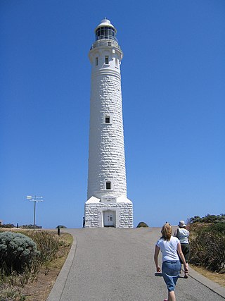
The Cape Leeuwin Lighthouse is a lighthouse located on the headland of Cape Leeuwin, the most south-westerly point on the mainland of the Australian Continent, in the state of Western Australia.

Rottnest Island lies 18 kilometres (11 mi) west of the coastline of Perth, Western Australia; it is 4.5 kilometres (2.8 mi) at its widest and 11 kilometres (6.8 mi) at its longest.

Bunbury Bridge was a single-track, timber railway bridge in East Perth in Western Australia. The bridge crossed the Swan River near Claise Brook and was built for passenger and freight traffic to Bunbury on the South Western Railway.

Most surf breaks in the Capes region – from Cape Naturaliste to Cape Leeuwin – within the larger area known as the South West region of Western Australia tend to have the name Margaret River attached, despite the wide geographic range of locations where the breaks are located.
The Ngari Capes Marine Park is a marine protected area on the lower south west coast of Western Australia, located approximately 250 kilometres (160 mi) south of Perth. The 123,790-hectare (305,900-acre) marine park was gazetted on 12 June 2012 and the park's western and southern boundaries are the limit of coastal waters of Western Australia, abutting the South-west Corner Marine Park located within the Australian Commonwealth exclusive economic zone.
Cape Clairault is located south of Yallingup in the coastal region between Cape Naturaliste and Cape Leeuwin.
Cape Hamelin is a headland seven kilometres south of Hamelin Bay in the capes region of south western Western Australia.

Turquoise Coast is a name attributed to a section of the coastline of Western Australia in the vicinity of Jurien Bay.
Government House Lake is a saline lake on Rottnest Island in Western Australia. It is partly reclaimed on its southern shore, for the Rottnest Island Airport. Adjacent lakes are Pearse Lakes to the west, Serpentine Lake to the south west, and Herschell and Garden Lakes to the north.

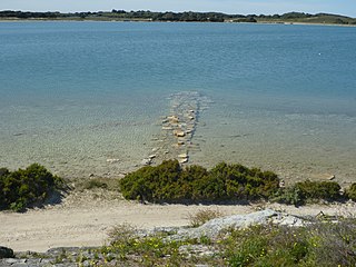
Cape Leeuwin water wheel, sometimes called the petrified water wheel, is a non-operating water wheel, near Cape Leeuwin, in the south-west of Western Australia. It was used to pump fresh water to the Cape Leeuwin Lighthouse. It is notable both for its coastal location and because it has become heavily calcified. The water wheel is located above a small cove, approximately 400m to the north of the Cape Leeuwin Lighthouse cottages. The base of the water wheel structure is just above the high-tide sea level.

